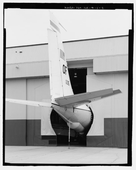
File:Detail of airplane tail protruding out of hangar doors, dock no. 491. Detail of canvas gasket allowing doors to close tightly around fuselage. View to north. - Offutt Air Force Base, HAER NE-9-F-3.tif
Size of this JPG preview of this TIF file: 479 × 599 pixels. Other resolutions: 192 × 240 pixels | 384 × 480 pixels | 614 × 768 pixels | 818 × 1,024 pixels | 1,637 × 2,048 pixels | 4,093 × 5,121 pixels.
Original file (4,093 × 5,121 pixels, file size: 19.99 MB, MIME type: image/tiff)
Captions
Captions
Add a one-line explanation of what this file represents
Summary edit
| Photographer |
Related names:
|
|||
| Title |
Detail of airplane tail protruding out of hangar doors, dock no. 491. Detail of canvas gasket allowing doors to close tightly around fuselage. View to north. - Offutt Air Force Base, Looking Glass Airborne Command Post, Nose Docks, On either side of Hangar Access Apron at Northwest end of Project Looking Glass Historic District, Bellevue, Sarpy County, NE |
|||
| Depicted place | Nebraska; Sarpy County; Bellevue | |||
| Date | Documentation compiled after 1968 | |||
| Dimensions | 4 x 5 in. | |||
| Current location |
Library of Congress Prints and Photographs Division Washington, D.C. 20540 USA http://hdl.loc.gov/loc.pnp/pp.print |
|||
| Accession number |
HAER NE-9-F-3 |
|||
| Credit line |
|
|||
| Notes |
|
|||
| Source | https://www.loc.gov/pictures/item/ne0078.photos.198189p | |||
| Permission (Reusing this file) |
|

| Object location | | View this and other nearby images on: OpenStreetMap |
|---|
File history
Click on a date/time to view the file as it appeared at that time.
| Date/Time | Thumbnail | Dimensions | User | Comment | |
|---|---|---|---|---|---|
| current | 02:23, 29 July 2014 |  | 4,093 × 5,121 (19.99 MB) | Fæ (talk | contribs) | GWToolset: Creating mediafile for Fæ. HABS 24 July 2014 (2001:2300) |
You cannot overwrite this file.
File usage on Commons
The following page uses this file:
File usage on other wikis
The following other wikis use this file:
- Usage on es.wikipedia.org