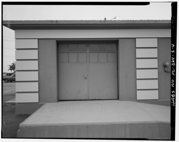
File:Detail of garage door on east side - MacDill Air Force Base, Quartermaster Gas and Oil House, 8103 Hanger Loop Drive, Tampa, Hillsborough County, FL HABS FLA,29-TAMP,52S-4.tif
Size of this JPG preview of this TIF file: 755 × 600 pixels. Other resolutions: 302 × 240 pixels | 605 × 480 pixels | 967 × 768 pixels | 1,280 × 1,017 pixels | 2,560 × 2,033 pixels | 5,000 × 3,971 pixels.
Original file (5,000 × 3,971 pixels, file size: 18.94 MB, MIME type: image/tiff)
Captions
Captions
Add a one-line explanation of what this file represents
Summary edit
| Detail of garage door on east side - MacDill Air Force Base, Quartermaster Gas and Oil House, 8103 Hanger Loop Drive, Tampa, Hillsborough County, FL | ||||
|---|---|---|---|---|
| Photographer |
Diesing, David H. Related names:
|
|||
| Title |
Detail of garage door on east side - MacDill Air Force Base, Quartermaster Gas and Oil House, 8103 Hanger Loop Drive, Tampa, Hillsborough County, FL |
|||
| Depicted place | Florida; Hillsborough County; Tampa | |||
| Date | 1994 | |||
| Dimensions | 4 x 5 in. | |||
| Current location |
Library of Congress Prints and Photographs Division Washington, D.C. 20540 USA http://hdl.loc.gov/loc.pnp/pp.print |
|||
| Accession number |
HABS FLA,29-TAMP,52S-4 |
|||
| Credit line |
|
|||
| Notes |
|
|||
| Source | https://www.loc.gov/pictures/item/fl0382.photos.331700p | |||
| Permission (Reusing this file) |
|
|||

| Object location | | View this and other nearby images on: OpenStreetMap |
|---|
File history
Click on a date/time to view the file as it appeared at that time.
| Date/Time | Thumbnail | Dimensions | User | Comment | |
|---|---|---|---|---|---|
| current | 08:06, 12 July 2014 |  | 5,000 × 3,971 (18.94 MB) | Fæ (talk | contribs) | GWToolset: Creating mediafile for Fæ. HABS 09 July 2014 (801:1000) |
You cannot overwrite this file.
File usage on Commons
The following page uses this file: