File:Detail view of south hangar doors looking northeast. - Manchester Airport, Large Hangar, East edge of airport between East Apron and Kelly Avenue, Manchester, Hillsborough County HAER NH,6-MANCH,13C-5.tif

Size of this JPG preview of this TIF file: 475 × 599 pixels. Other resolutions: 190 × 240 pixels | 380 × 480 pixels | 609 × 768 pixels | 812 × 1,024 pixels | 1,623 × 2,048 pixels | 3,963 × 5,000 pixels.
Original file (3,963 × 5,000 pixels, file size: 18.9 MB, MIME type: image/tiff)
Captions
Captions
Add a one-line explanation of what this file represents
Summary edit
| Detail view of south hangar doors looking northeast. - Manchester Airport, Large Hangar, East edge of airport between East Apron and Kelly Avenue, Manchester, Hillsborough County, NH | ||||
|---|---|---|---|---|
| Photographer |
Brewster, Robert |
|||
| Title |
Detail view of south hangar doors looking northeast. - Manchester Airport, Large Hangar, East edge of airport between East Apron and Kelly Avenue, Manchester, Hillsborough County, NH |
|||
| Depicted place | New Hampshire; Hillsborough County; Manchester | |||
| Date | 1998 | |||
| Dimensions | 4 x 5 in. | |||
| Current location |
Library of Congress Prints and Photographs Division Washington, D.C. 20540 USA http://hdl.loc.gov/loc.pnp/pp.print |
|||
| Accession number |
HAER NH,6-MANCH,13C-5 |
|||
| Credit line |
|
|||
| Notes |
|
|||
| Source | https://www.loc.gov/pictures/item/nh0269.photos.346592p | |||
| Permission (Reusing this file) |
|
|||

| Object location | | View this and other nearby images on: OpenStreetMap |
|---|
File history
Click on a date/time to view the file as it appeared at that time.
| Date/Time | Thumbnail | Dimensions | User | Comment | |
|---|---|---|---|---|---|
| current | 06:19, 29 July 2014 | 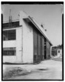 | 3,963 × 5,000 (18.9 MB) | Fæ (talk | contribs) | GWToolset: Creating mediafile for Fæ. HABS 24 July 2014 (2001:2300) |
You cannot overwrite this file.
File usage on Commons
The following page uses this file: