File:ELEVATION, SOUTHEAST TRUSS. - Pottersburg Bridge, Spanning Big Darby Creek, North Lewisburg Road (CR 164), North Lewisburg, Union County, OH HAER OH-125-10.tif

Size of this JPG preview of this TIF file: 800 × 577 pixels. Other resolutions: 320 × 231 pixels | 640 × 461 pixels | 1,024 × 738 pixels | 1,280 × 923 pixels | 2,560 × 1,845 pixels | 5,094 × 3,672 pixels.
Original file (5,094 × 3,672 pixels, file size: 17.84 MB, MIME type: image/tiff)
Captions
Captions
Add a one-line explanation of what this file represents
Summary edit
| ELEVATION, SOUTHEAST TRUSS. - Pottersburg Bridge, Spanning Big Darby Creek, North Lewisburg Road (CR 164), North Lewisburg, Union County, OH | ||||
|---|---|---|---|---|
| Photographer |
Lowe, Jet Related names:
|
|||
| Title |
ELEVATION, SOUTHEAST TRUSS. - Pottersburg Bridge, Spanning Big Darby Creek, North Lewisburg Road (CR 164), North Lewisburg, Union County, OH |
|||
| Depicted place | Ohio; Union County; North Lewisburg | |||
| Date | 2003 | |||
| Dimensions | 5 x 7 in. | |||
| Current location |
Library of Congress Prints and Photographs Division Washington, D.C. 20540 USA http://hdl.loc.gov/loc.pnp/pp.print |
|||
| Accession number |
HAER OH-125-10 |
|||
| Credit line |
|
|||
| Notes |
|
|||
| Source | https://www.loc.gov/pictures/item/oh1926.photos.199998p | |||
| Permission (Reusing this file) |
|
|||

| Object location | | View this and other nearby images on: OpenStreetMap |
|---|
File history
Click on a date/time to view the file as it appeared at that time.
| Date/Time | Thumbnail | Dimensions | User | Comment | |
|---|---|---|---|---|---|
| current | 01:50, 2 August 2014 | 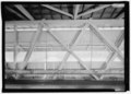 | 5,094 × 3,672 (17.84 MB) | Fæ (talk | contribs) | GWToolset: Creating mediafile for Fæ. HABS 2014-08-01 2601-2900 missing |
You cannot overwrite this file.
File usage on Commons
The following page uses this file: