File:ELEVATION VIEW OF MURAL "AFRICA HOUSE-MELROSE" BY CLEMENTINE HUNTER IN NORTHEAST CORNER, EAST WALL, WITH SCALE - Melrose Plantation, African House, State Highway 119, Melrose, HABS LA,35-MELRO,1B-18.tif

Size of this JPG preview of this TIF file: 800 × 572 pixels. Other resolutions: 320 × 229 pixels | 640 × 457 pixels | 1,024 × 732 pixels | 1,280 × 915 pixels | 2,560 × 1,830 pixels | 4,954 × 3,541 pixels.
Original file (4,954 × 3,541 pixels, file size: 16.73 MB, MIME type: image/tiff)
Captions
Captions
Add a one-line explanation of what this file represents
Summary edit
| ELEVATION VIEW OF MURAL "AFRICA HOUSE-MELROSE" BY CLEMENTINE HUNTER IN NORTHEAST CORNER, EAST WALL, WITH SCALE - Melrose Plantation, African House, State Highway 119, Melrose, Natchitoches Parish, LA | ||||
|---|---|---|---|---|
| Title |
ELEVATION VIEW OF MURAL "AFRICA HOUSE-MELROSE" BY CLEMENTINE HUNTER IN NORTHEAST CORNER, EAST WALL, WITH SCALE - Melrose Plantation, African House, State Highway 119, Melrose, Natchitoches Parish, LA |
|||
| Description |
The Melrose Plantation murals — painted by Clementine Hunter in 1955, inside the African House at Melrose Plantation.
|
|||
| Depicted place | Louisiana; Natchitoches Parish; Melrose | |||
| Date | Documentation compiled after 1933 | |||
| Dimensions | 5 x 7 in. | |||
| Current location |
Library of Congress Prints and Photographs Division Washington, D.C. 20540 USA http://hdl.loc.gov/loc.pnp/pp.print |
|||
| Accession number |
HABS LA,35-MELRO,1B-18 |
|||
| Credit line |
|
|||
| Notes |
|
|||
| References |
|
|||
| Source | https://www.loc.gov/pictures/item/la0212.photos.204865p | |||
| Permission (Reusing this file) |
|
|||

| Object location | | View this and other nearby images on: OpenStreetMap |
|---|
File history
Click on a date/time to view the file as it appeared at that time.
| Date/Time | Thumbnail | Dimensions | User | Comment | |
|---|---|---|---|---|---|
| current | 00:16, 21 July 2014 | 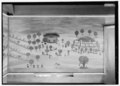 | 4,954 × 3,541 (16.73 MB) | Fæ (talk | contribs) | GWToolset: Creating mediafile for Fæ. HABS 16 July 2014 (1201:1400) |
You cannot overwrite this file.
File usage on Commons
The following page uses this file: