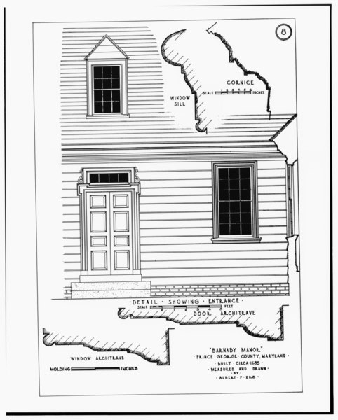
File:ENTRANCE DOOR AND DETAIL OF ENTRANCE DOOR ARCHITRAVE - Barnaby Manor, Wheeler and Wheeler Hill Roads, Oxon Hill, Prince George's County, MD HABS MD,17-OXHI.V,2-2.tif
Size of this JPG preview of this TIF file: 482 × 599 pixels. Other resolutions: 193 × 240 pixels | 386 × 480 pixels | 618 × 768 pixels | 823 × 1,024 pixels | 1,647 × 2,048 pixels | 4,021 × 5,000 pixels.
Original file (4,021 × 5,000 pixels, file size: 19.18 MB, MIME type: image/tiff)
Captions
Captions
Add a one-line explanation of what this file represents
Summary edit
| ENTRANCE DOOR AND DETAIL OF ENTRANCE DOOR ARCHITRAVE - Barnaby Manor, Wheeler and Wheeler Hill Roads, Oxon Hill, Prince George's County, MD | ||||
|---|---|---|---|---|
| Title |
ENTRANCE DOOR AND DETAIL OF ENTRANCE DOOR ARCHITRAVE - Barnaby Manor, Wheeler and Wheeler Hill Roads, Oxon Hill, Prince George's County, MD |
|||
| Description |
Erb, Albert P, delineator |
|||
| Depicted place | Maryland; Prince George's County; Oxon Hill | |||
| Date | Documentation compiled after 1933 | |||
| Dimensions | 8 x 10 in. | |||
| Current location |
Library of Congress Prints and Photographs Division Washington, D.C. 20540 USA http://hdl.loc.gov/loc.pnp/pp.print |
|||
| Accession number |
HABS MD,17-OXHI.V,2-2 |
|||
| Credit line |
|
|||
| Notes |
|
|||
| Source | https://www.loc.gov/pictures/item/md0547.photos.083545p | |||
| Permission (Reusing this file) |
|
|||

| Object location | | View this and other nearby images on: OpenStreetMap |
|---|
File history
Click on a date/time to view the file as it appeared at that time.
| Date/Time | Thumbnail | Dimensions | User | Comment | |
|---|---|---|---|---|---|
| current | 23:58, 21 July 2014 |  | 4,021 × 5,000 (19.18 MB) | Fæ (talk | contribs) | GWToolset: Creating mediafile for Fæ. HABS 21 July 2014 (1601:1800) |
You cannot overwrite this file.
File usage on Commons
The following page uses this file: