File:EXTERIOR VIEW, LOOKING WEST FROM UNIVERSITY PARK ALONG THE WARRIOR RIVER TOWARDS THE BRIDGES LINKING TUSCALOOSA AND NORTHPORT, SHOWING THE GATE OF INDENTATION OF THE SOUTH LOCK HAER ALA,63-TUSLO,28-1.tif

Size of this JPG preview of this TIF file: 431 × 599 pixels. Other resolutions: 173 × 240 pixels | 345 × 480 pixels | 553 × 768 pixels | 737 × 1,024 pixels | 1,474 × 2,048 pixels | 3,598 × 5,000 pixels.
Original file (3,598 × 5,000 pixels, file size: 17.16 MB, MIME type: image/tiff)
Captions
Captions
Add a one-line explanation of what this file represents
Summary edit
| Photographer |
Lowe, Jet Related names:
|
|||
| Title |
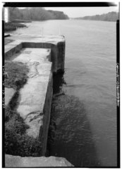
EXTERIOR VIEW, LOOKING WEST FROM UNIVERSITY PARK ALONG THE WARRIOR RIVER TOWARDS THE BRIDGES LINKING TUSCALOOSA AND NORTHPORT, SHOWING THE GATE OF INDENTATION OF THE SOUTH LOCK WALL OF LOCK NO. 3, ONE OF THE ORIGINAL 19 WARRIOR RIVER LOCKS. - Warrior River, Lock No. 3 Wall, River Road at University Park, Tuscaloosa, Tuscaloosa County, AL |
|||
| Depicted place | Alabama; Tuscaloosa County; Tuscaloosa | |||
| Date | 1993 | |||
| Dimensions | 5 x 7 in. | |||
| Current location |
Library of Congress Prints and Photographs Division Washington, D.C. 20540 USA http://hdl.loc.gov/loc.pnp/pp.print |
|||
| Accession number |
HAER ALA,63-TUSLO,28-1 |
|||
| Credit line |
|
|||
| Notes |
|
|||
| Source | https://www.loc.gov/pictures/item/al1026.photos.046291p | |||
| Permission (Reusing this file) |
|

| Object location | | View this and other nearby images on: OpenStreetMap |
|---|
File history
Click on a date/time to view the file as it appeared at that time.
| Date/Time | Thumbnail | Dimensions | User | Comment | |
|---|---|---|---|---|---|
| current | 20:31, 30 June 2014 |  | 3,598 × 5,000 (17.16 MB) | Fæ (talk | contribs) | GWToolset: Creating mediafile for Fæ. HABS batch upload 29 June 2014 (101:150) |
You cannot overwrite this file.
File usage on Commons
The following page uses this file: