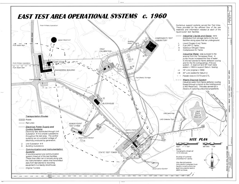
File:East Test Area Operational Systems c. 1960 - Marshall Space Flight Center, East Test Area, Dodd Road, Huntsville, Madison County, AL HAER ALA,45-HUVI.V,7F- (sheet 5 of 6).tif
Size of this JPG preview of this TIF file: 777 × 599 pixels. Other resolutions: 311 × 240 pixels | 622 × 480 pixels | 996 × 768 pixels | 1,280 × 987 pixels | 2,560 × 1,975 pixels | 17,670 × 13,632 pixels.
Original file (17,670 × 13,632 pixels, file size: 2.73 MB, MIME type: image/tiff)
Captions
Captions
Add a one-line explanation of what this file represents
Summary edit
| Warning | The original file is very high-resolution. It might not load properly or could cause your browser to freeze when opened at full size. |
|---|
| East Test Area Operational Systems c. 1960 - Marshall Space Flight Center, East Test Area, Dodd Road, Huntsville, Madison County, AL | ||||
|---|---|---|---|---|
| Photographer |
Hillis, Wendy |
|||
| Title |
East Test Area Operational Systems c. 1960 - Marshall Space Flight Center, East Test Area, Dodd Road, Huntsville, Madison County, AL |
|||
| Depicted place | Alabama; Madison County; Huntsville | |||
| Date | 1996 | |||
| Dimensions | 34 x 44 in. (E size) | |||
| Current location |
Library of Congress Prints and Photographs Division Washington, D.C. 20540 USA http://hdl.loc.gov/loc.pnp/pp.print |
|||
| Accession number |
HAER ALA,45-HUVI.V,7F- (sheet 5 of 6) |
|||
| Credit line |
|
|||
| Notes |
|
|||
| Source | https://www.loc.gov/pictures/item/al1207.sheet.00005a | |||
| Permission (Reusing this file) |
|
|||
| Other versions |
.png) .png) .png) .png) .png) .png) |
|||

| Object location | | View this and other nearby images on: OpenStreetMap |
|---|
File history
Click on a date/time to view the file as it appeared at that time.
| Date/Time | Thumbnail | Dimensions | User | Comment | |
|---|---|---|---|---|---|
| current | 08:25, 1 July 2014 |  | 17,670 × 13,632 (2.73 MB) | Fæ (talk | contribs) | GWToolset: Creating mediafile for Fæ. HABS batch upload 29 June 2014 (101:150) |
You cannot overwrite this file.
File usage on Commons
The following page uses this file: