File:East wall of 144 Poplar along North Hunter Street. View to the west. - Mary Pache House, 144 Poplar Street, Stockton, San Joaquin County, CA HABS CA-2733-2.tif

Size of this JPG preview of this TIF file: 752 × 599 pixels. Other resolutions: 301 × 240 pixels | 602 × 480 pixels | 964 × 768 pixels | 1,280 × 1,020 pixels | 2,560 × 2,040 pixels | 5,435 × 4,332 pixels.
Original file (5,435 × 4,332 pixels, file size: 22.46 MB, MIME type: image/tiff)
Captions
Captions
Add a one-line explanation of what this file represents
Summary edit
| East wall of 144 Poplar along North Hunter Street. View to the west. - Mary Pache House, 144 Poplar Street, Stockton, San Joaquin County, CA | ||||
|---|---|---|---|---|
| Photographer |
Anderson, Ed Related names:
|
|||
| Title |
East wall of 144 Poplar along North Hunter Street. View to the west. - Mary Pache House, 144 Poplar Street, Stockton, San Joaquin County, CA |
|||
| Depicted place | California; San Joaquin County; Stockton | |||
| Date | 2002 | |||
| Dimensions | 4 x 5 in. | |||
| Current location |
Library of Congress Prints and Photographs Division Washington, D.C. 20540 USA http://hdl.loc.gov/loc.pnp/pp.print |
|||
| Accession number |
HABS CA-2733-2 |
|||
| Credit line |
|
|||
| Notes |
|
|||
| Source | https://www.loc.gov/pictures/item/ca3138.photos.206844p | |||
| Permission (Reusing this file) |
|
|||

| Object location | | View this and other nearby images on: OpenStreetMap |
|---|
File history
Click on a date/time to view the file as it appeared at that time.
| Date/Time | Thumbnail | Dimensions | User | Comment | |
|---|---|---|---|---|---|
| current | 17:49, 6 July 2014 | 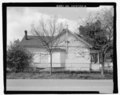 | 5,435 × 4,332 (22.46 MB) | Fæ (talk | contribs) | GWToolset: Creating mediafile for Fæ. HABS 05 July 2014 (501:600) |
You cannot overwrite this file.
File usage on Commons
The following page uses this file: