File:English unitary authorities 2009.svg

Size of this PNG preview of this SVG file: 494 × 600 pixels. Other resolutions: 198 × 240 pixels | 395 × 480 pixels | 633 × 768 pixels | 844 × 1,024 pixels | 1,687 × 2,048 pixels | 1,039 × 1,261 pixels.
Original file (SVG file, nominally 1,039 × 1,261 pixels, file size: 1 MB)
Captions
Captions
Add a one-line explanation of what this file represents
Summary edit
| Description |
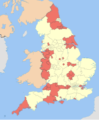
English: Map showing the unitary authorities of England highlighted, together with the all the other top-tier administrative subdivisions (shire counties, metropolitan counties, and London boroughs) from 2009 (still valid in 2012).
Equirectangular map projection on WGS 84 datum, with N/S stretched 170% Geographic limits:
|
| Date | (UTC) |
| Source |
This file was derived from: English administrative divisions 2010.svg:  |
| Author |
|
| Other versions |
| This is a retouched picture, which means that it has been digitally altered from its original version. Modifications: recoloured with some thicker boundary lines. The original can be viewed here: English administrative divisions 2010.svg:
|
Licensing edit
I, the copyright holder of this work, hereby publish it under the following licenses:
This file is licensed under the Creative Commons Attribution-Share Alike 3.0 Unported license.
Attribution: Nilfanion and Dr Greg
- You are free:
- to share – to copy, distribute and transmit the work
- to remix – to adapt the work
- Under the following conditions:
- attribution – You must give appropriate credit, provide a link to the license, and indicate if changes were made. You may do so in any reasonable manner, but not in any way that suggests the licensor endorses you or your use.
- share alike – If you remix, transform, or build upon the material, you must distribute your contributions under the same or compatible license as the original.

|
Permission is granted to copy, distribute and/or modify this document under the terms of the GNU Free Documentation License, Version 1.2 or any later version published by the Free Software Foundation; with no Invariant Sections, no Front-Cover Texts, and no Back-Cover Texts. A copy of the license is included in the section entitled GNU Free Documentation License. |
You may select the license of your choice.
Original upload log edit
This image is a derivative work of the following images:
- File:English_administrative_divisions_2010.svg licensed with Cc-by-sa-3.0, GFDL
- 2010-11-23T22:02:28Z Nilfanion 1108x1345 (374390 Bytes) England only
- 2010-11-23T22:00:33Z Nilfanion 1108x1345 (410564 Bytes) {{Information |Description=Map showing the all top-tier administrative subdivisions of England (shire counties, metropolitan counties, London boroughs and Unitary Authorities) in 2010 Equirectangular map projection on WGS 84
Uploaded with derivativeFX
File history
Click on a date/time to view the file as it appeared at that time.
| Date/Time | Thumbnail | Dimensions | User | Comment | |
|---|---|---|---|---|---|
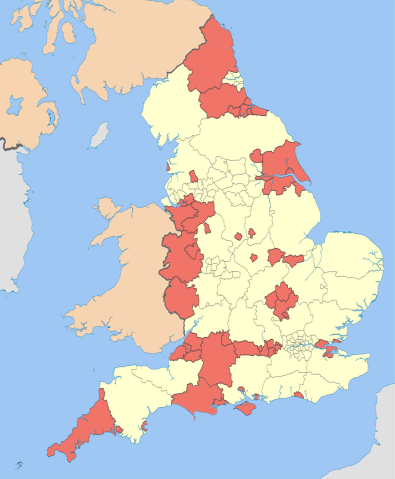
| current | 23:50, 8 April 2019 | | 1,039 × 1,261 (1 MB) | The Equalizer (talk | contribs) | Prior image had cropped sides |
| 23:47, 8 April 2019 |  | 744 × 1,052 (1 MB) | The Equalizer (talk | contribs) | Prior upload not displaying | |
| 23:04, 8 April 2019 |  | 1,108 × 1,345 (204 KB) | The Equalizer (talk | contribs) | Updated UAs in Dorset | |
| 12:23, 6 May 2012 |  | 1,108 × 1,345 (380 KB) | Dr Greg (talk | contribs) | paler boundary lines | |
| 22:17, 20 March 2012 |  | 1,108 × 1,345 (376 KB) | Dr Greg (talk | contribs) | == {{int:filedesc}} == {{Information |Description={{en|1=Map showing the en:unitary authorities of England highlighted, together with the all the other top-tier administrative subdivisions (shire counties, metropolitan counties, and London boroug... |
You cannot overwrite this file.
File usage on Commons
The following 5 pages use this file:
File usage on other wikis
The following other wikis use this file:
- Usage on af.wikipedia.org
- Usage on fr.wikipedia.org
- Usage on hr.wikipedia.org
- Usage on it.wikipedia.org
- Usage on ja.wikipedia.org
- Usage on ko.wikipedia.org
- Usage on no.wikipedia.org
- Usage on oc.wikipedia.org
- Usage on sh.wikipedia.org