File:European monarchies.svg

Size of this PNG preview of this SVG file: 592 × 599 pixels. Other resolutions: 237 × 240 pixels | 474 × 480 pixels | 759 × 768 pixels | 1,012 × 1,024 pixels | 2,023 × 2,048 pixels | 1,238 × 1,253 pixels.
Original file (SVG file, nominally 1,238 × 1,253 pixels, file size: 825 KB)
Captions
Captions
Add a one-line explanation of what this file represents
Summary edit
| Description | |
| Date | |
| Source | Own work |
| Author | User:Peeperman |
| Other versions |
 |
| SVG development |
Licensing edit
| This file is licensed under the Creative Commons Attribution-Share Alike 3.0 Unported license. Subject to disclaimers. | ||
| ||
| This licensing tag was added to this file as part of the GFDL licensing update. |

|
Permission is granted to copy, distribute and/or modify this document under the terms of the GNU Free Documentation License, Version 1.2 or any later version published by the Free Software Foundation; with no Invariant Sections, no Front-Cover Texts, and no Back-Cover Texts. A copy of the license is included in the section entitled GNU Free Documentation License. Subject to disclaimers. |
File history
Click on a date/time to view the file as it appeared at that time.
| Date/Time | Thumbnail | Dimensions | User | Comment | |
|---|---|---|---|---|---|
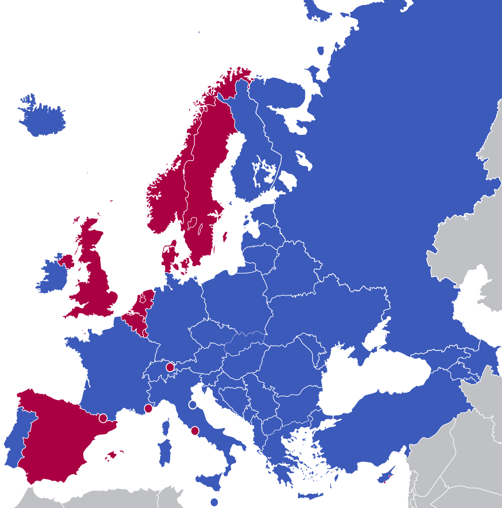
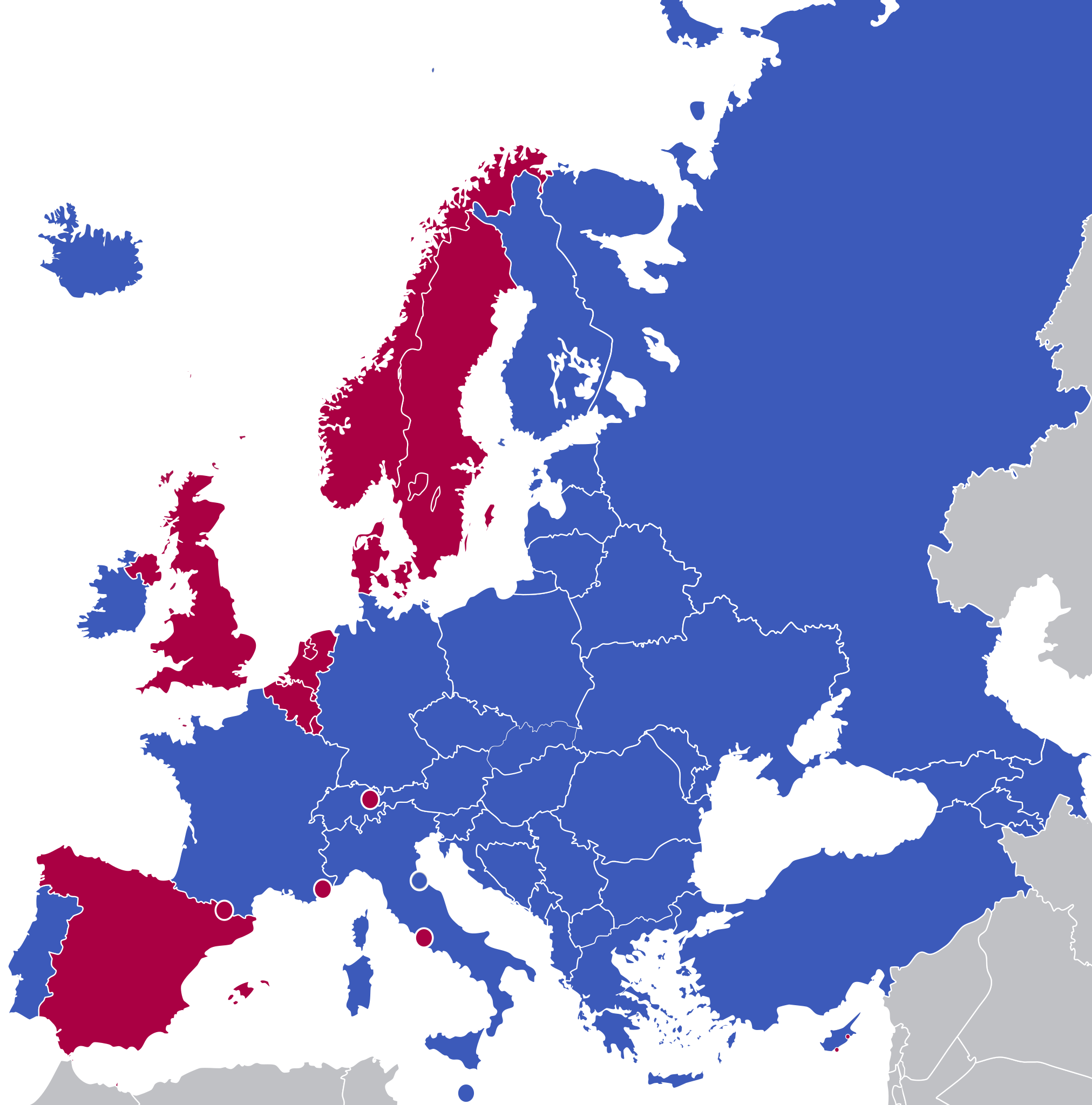
| current | 12:21, 5 March 2023 | | 1,238 × 1,253 (825 KB) | Iktsokh (talk | contribs) | If transcontinental Russia and Turkey are included, as well as Cyprus geographically located in Asia, then the countries of Transcaucasia should also figure. |
| 00:47, 2 March 2023 |  | 1,238 × 1,253 (665 KB) | Foghe (talk | contribs) | Stretching. | |
| 14:31, 8 December 2022 |  | 1,238 × 1,253 (839 KB) | Iktsokh (talk | contribs) | Correction | |
| 11:21, 2 September 2022 |  | 4,600 × 4,181 (2.79 MB) | Рагин1987 (talk | contribs) | Extended map | |
| 16:21, 16 July 2020 |  | 1,238 × 1,253 (665 KB) | Hanzlan (talk | contribs) | minor edit | |
| 16:54, 9 June 2012 |  | 1,238 × 1,253 (655 KB) | Peeperman (talk | contribs) | color edit | |
| 17:08, 8 June 2012 |  | 1,222 × 1,249 (655 KB) | Peeperman (talk | contribs) | minor edit | |
| 17:06, 8 June 2012 |  | 1,222 × 1,249 (655 KB) | Peeperman (talk | contribs) | minor edit | |
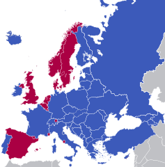
| 16:51, 8 June 2012 |  | 1,222 × 1,249 (651 KB) | Peeperman (talk | contribs) | == {{int:filedesc}} == {{legend|#C83232|monarchy}} {{legend|#967BFF|republic with pretenders}} {{legend|#0055D2|republic}} == {{int:license}} == {{GFDL-en|migration=relicense}} Category:Political maps of Europe |
You cannot overwrite this file.
File usage on Commons
The following page uses this file:
File usage on other wikis
The following other wikis use this file:
- Usage on ar.wikipedia.org
- Usage on el.wikipedia.org
- Usage on en.wikipedia.org
- Usage on eo.wikipedia.org
- Usage on hr.wikipedia.org
- Usage on id.wikipedia.org
- Usage on it.wikipedia.org
- Usage on nl.wikipedia.org
- Usage on pt.wikipedia.org
- Usage on ru.wikipedia.org
- Usage on sr.wikipedia.org
- Usage on sv.wikipedia.org
- Usage on uk.wikipedia.org
- Usage on ur.wikipedia.org
- Usage on zh.wikipedia.org