File:FRONT, SOUTHEAST ELEVATION, LOOKING NORTHWEST - Bonfield's Service Station, 6124 MacArthur Boulevard, Glen Echo, Montgomery County, MD HABS MD,16-GLENEC.V,1-2.tif

Size of this JPG preview of this TIF file: 800 × 578 pixels. Other resolutions: 320 × 231 pixels | 640 × 462 pixels | 1,024 × 740 pixels | 1,280 × 925 pixels | 2,560 × 1,849 pixels | 5,000 × 3,612 pixels.
Original file (5,000 × 3,612 pixels, file size: 17.23 MB, MIME type: image/tiff)
Captions
Captions
Add a one-line explanation of what this file represents
Summary edit
| FRONT, SOUTHEAST ELEVATION, LOOKING NORTHWEST - Bonfield's Service Station, 6124 MacArthur Boulevard, Glen Echo, Montgomery County, MD
( |
||||||||||||||||||||||||||
|---|---|---|---|---|---|---|---|---|---|---|---|---|---|---|---|---|---|---|---|---|---|---|---|---|---|---|
| Photographer |
|
|||||||||||||||||||||||||
| Title |
FRONT, SOUTHEAST ELEVATION, LOOKING NORTHWEST - Bonfield's Service Station, 6124 MacArthur Boulevard, Glen Echo, Montgomery County, MD |
|||||||||||||||||||||||||
| Depicted place | Maryland; Montgomery County; Brookmont | |||||||||||||||||||||||||
| Date | May 1987 | |||||||||||||||||||||||||
| Dimensions | 5 x 7 in. | |||||||||||||||||||||||||
| Current location |
Library of Congress Prints and Photographs Division Washington, D.C. 20540 USA |
|||||||||||||||||||||||||
| Accession number |
HABS MD,16-GLENEC.V,1-2 |
|||||||||||||||||||||||||
| Credit line |
|
|||||||||||||||||||||||||
| Notes |
|
|||||||||||||||||||||||||
| Source |
|
|||||||||||||||||||||||||
| Permission (Reusing this file) |
|
|||||||||||||||||||||||||


| Object location | | View this and other nearby images on: OpenStreetMap |
|---|
File history
Click on a date/time to view the file as it appeared at that time.
| Date/Time | Thumbnail | Dimensions | User | Comment | |
|---|---|---|---|---|---|
| current | 01:08, 23 July 2014 | 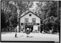 | 5,000 × 3,612 (17.23 MB) | Fæ (talk | contribs) | GWToolset: Creating mediafile for Fæ. HABS 21 July 2014 (1601:1800) |
You cannot overwrite this file.
File usage on Commons
The following page uses this file: