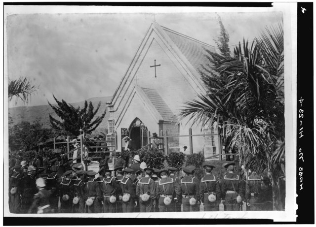
File:FUNERAL OF KING KALAKAUA, 1891 (Photocopy, made 1966, of photograph in the Hawaii State Archives). - Royal Mausoleum, 2261 Nuuanu Avenue, Honolulu, Honolulu County, HI HABS HI,2-HONLU,25-4.tif

Size of this JPG preview of this TIF file: 800 × 576 pixels. Other resolutions: 320 × 230 pixels | 640 × 461 pixels | 1,024 × 737 pixels | 1,280 × 922 pixels | 2,560 × 1,844 pixels | 5,000 × 3,601 pixels.
Original file (5,000 × 3,601 pixels, file size: 17.17 MB, MIME type: image/tiff)
Captions
Captions
Add a one-line explanation of what this file represents
Summary edit
| FUNERAL OF KING KALAKAUA, 1891 (Photocopy, made 1966, of photograph in the Hawaii State Archives). - Royal Mausoleum, 2261 Nuuanu Avenue, Honolulu, Honolulu County, HI | ||||
|---|---|---|---|---|
| Title |
FUNERAL OF KING KALAKAUA, 1891 (Photocopy, made 1966, of photograph in the Hawaii State Archives). - Royal Mausoleum, 2261 Nuuanu Avenue, Honolulu, Honolulu County, HI |
|||
| Depicted place | Hawaii; Honolulu County; Honolulu | |||
| Date | Documentation compiled after 1933 | |||
| Dimensions | 5 x 7 in. | |||
| Current location |
Library of Congress Prints and Photographs Division Washington, D.C. 20540 USA http://hdl.loc.gov/loc.pnp/pp.print |
|||
| Accession number |
HABS HI,2-HONLU,25-4 |
|||
| Credit line |
|
|||
| Notes |
|
|||
| Source | https://www.loc.gov/pictures/item/hi0026.photos.057979p | |||
| Permission (Reusing this file) |
|
|||

| Object location | | View this and other nearby images on: OpenStreetMap |
|---|
File history
Click on a date/time to view the file as it appeared at that time.
| Date/Time | Thumbnail | Dimensions | User | Comment | |
|---|---|---|---|---|---|
| current | 21:29, 28 July 2014 |  | 5,000 × 3,601 (17.17 MB) | Fæ (talk | contribs) | GWToolset: Creating mediafile for Fæ. Missing 801 |
You cannot overwrite this file.
File usage on Commons
The following page uses this file: