File:Ffrith station site geograph-3881162-by-Ben-Brooksbank.jpg

Size of this preview: 800 × 530 pixels. Other resolutions: 320 × 212 pixels | 640 × 424 pixels | 1,024 × 679 pixels | 1,280 × 849 pixels | 2,342 × 1,553 pixels.
Original file (2,342 × 1,553 pixels, file size: 3.96 MB, MIME type: image/jpeg)
Captions
Captions
Add a one-line explanation of what this file represents
Summary edit
| Description |
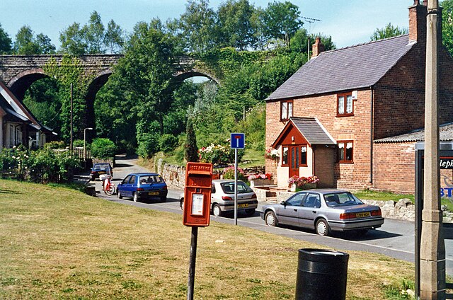
English: Site of former Frith station, 1995. View northward on Valley Road to the viaduct that formerly carried the GWR & LNWR (Wrexham & Minera) Joint) line, Wrexham (to left) - (to right) Coed Talon - Mold line. The station (just to the left) and line had been closed since 27/3/50, but the substantial viaduct over the Nant-y-Ffrith river survives. (This site had been difficult to pin-point and photograph in 1995 and also to establish on recent Streetview as so much had changed since 1995; once again I am indebted to Stephen Wilks for confirmation). |
| Date | |
| Source | From geograph.org.uk |
| Author | Ben Brooksbank |
| Permission (Reusing this file) |
Creative Commons Attribution Share-alike license 2.0 |
| Camera location | | View this and other nearby images on: OpenStreetMap |
|---|
Licensing edit

|
This image was taken from the Geograph project collection. See this photograph's page on the Geograph website for the photographer's contact details. The copyright on this image is owned by Ben Brooksbank and is licensed for reuse under the Creative Commons Attribution-ShareAlike 2.0 license.
|
This file is licensed under the Creative Commons Attribution-Share Alike 2.0 Generic license.
Attribution: Ben Brooksbank
- You are free:
- to share – to copy, distribute and transmit the work
- to remix – to adapt the work
- Under the following conditions:
- attribution – You must give appropriate credit, provide a link to the license, and indicate if changes were made. You may do so in any reasonable manner, but not in any way that suggests the licensor endorses you or your use.
- share alike – If you remix, transform, or build upon the material, you must distribute your contributions under the same or compatible license as the original.
File history
Click on a date/time to view the file as it appeared at that time.
| Date/Time | Thumbnail | Dimensions | User | Comment | |
|---|---|---|---|---|---|
| current | 09:06, 29 March 2014 | | 2,342 × 1,553 (3.96 MB) | Chevin (talk | contribs) | == {{int:filedesc}} == {{Information |Description={{en|1='''Site of former Frith station, 1995.'''<br/> View northward on Valley Road to the viaduct that formerly carried the GWR & LNWR (Wrexham & Minera) Joint) line, Wrexham (to left) - (to right) Coe... |
You cannot overwrite this file.
File usage on Commons
The following page uses this file:
File usage on other wikis
The following other wikis use this file:
- Usage on en.wikipedia.org
- Usage on eu.wikipedia.org
- Usage on www.wikidata.org