File:Flood damaged foot bridge at Tamarack Creek on alignment of Old Big Oak Flat Road. Looking northeast - Big Oak Flat Road, Between Big Oak Flat Entrance and Merced River, HAER CAL,22-YOSEM,29-26.tif

Size of this JPG preview of this TIF file: 748 × 599 pixels. Other resolutions: 300 × 240 pixels | 599 × 480 pixels | 959 × 768 pixels | 1,278 × 1,024 pixels | 2,556 × 2,048 pixels | 5,568 × 4,461 pixels.
Original file (5,568 × 4,461 pixels, file size: 23.69 MB, MIME type: image/tiff)
Captions
Captions
Add a one-line explanation of what this file represents
Summary edit
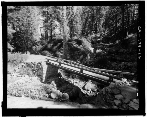
| Flood damaged foot bridge at Tamarack Creek on alignment of Old Big Oak Flat Road. Looking northeast - Big Oak Flat Road, Between Big Oak Flat Entrance and Merced River, Yosemite Village, Mariposa County, CA | ||||
|---|---|---|---|---|
| Photographer |
Grogan, Brian Related names:
|
|||
| Title |
Flood damaged foot bridge at Tamarack Creek on alignment of Old Big Oak Flat Road. Looking northeast - Big Oak Flat Road, Between Big Oak Flat Entrance and Merced River, Yosemite Village, Mariposa County, CA |
|||
| Depicted place | California; Mariposa County; Yosemite Village | |||
| Date | 2001 | |||
| Dimensions | 4 x 5 in. | |||
| Current location |
Library of Congress Prints and Photographs Division Washington, D.C. 20540 USA http://hdl.loc.gov/loc.pnp/pp.print |
|||
| Accession number |
HAER CAL,22-YOSEM,29-26 |
|||
| Credit line |
|
|||
| Notes |
|
|||
| Source | https://www.loc.gov/pictures/item/ca1918.photos.190778p | |||
| Permission (Reusing this file) |
|
|||

| Object location | | View this and other nearby images on: OpenStreetMap |
|---|
File history
Click on a date/time to view the file as it appeared at that time.
| Date/Time | Thumbnail | Dimensions | User | Comment | |
|---|---|---|---|---|---|
| current | 06:19, 5 July 2014 |  | 5,568 × 4,461 (23.69 MB) | Fæ (talk | contribs) | GWToolset: Creating mediafile for Fæ. HABS batch upload 2 July 2014 (301:400) |
You cannot overwrite this file.
File usage on Commons
The following page uses this file:
File usage on other wikis
The following other wikis use this file:
- Usage on fr.wikipedia.org
- Usage on www.wikidata.org