File:Fragmentation of the Abbasid Caliphate.jpg

Size of this preview: 800 × 538 pixels. Other resolutions: 320 × 215 pixels | 640 × 430 pixels | 1,024 × 688 pixels | 1,344 × 903 pixels.
Original file (1,344 × 903 pixels, file size: 311 KB, MIME type: image/jpeg)
Captions
Captions
Add a one-line explanation of what this file represents
| Description |
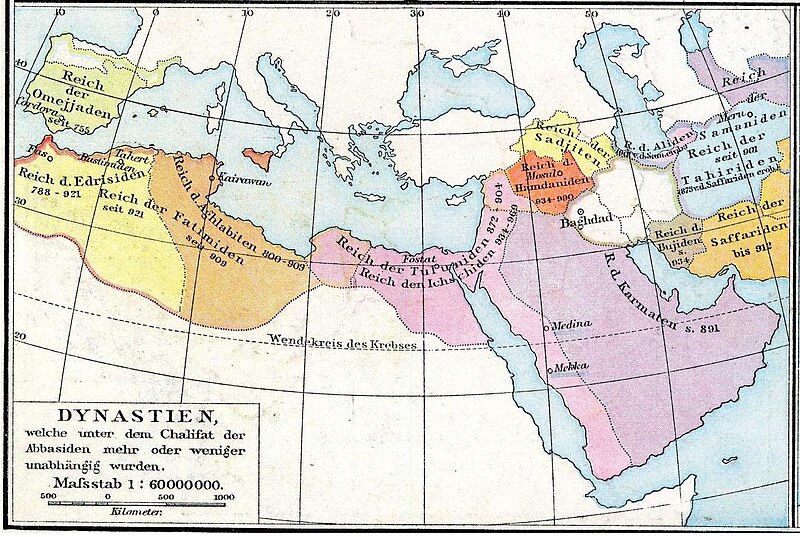
Deutsch: Das Reich der Kalifen bis 945. Karte aus dem Historischen Handatlas von Gustav Droysen, 1886 |
| Date | (UTC) |
| Source | |
| Author |
|
| Other versions | العربيَّة |
| This is a retouched picture, which means that it has been digitally altered from its original version. The original can be viewed here: Arabische Eroberung 2.jpg:
|
|
This work is in the public domain in its country of origin and other countries and areas where the copyright term is the author's life plus 100 years or fewer. This work is in the public domain in the United States because it was published (or registered with the U.S. Copyright Office) before January 1, 1929. | |
| This file has been identified as being free of known restrictions under copyright law, including all related and neighboring rights. | |
Original upload log edit
This image is a derivative work of the following images:
- File:Arabische_Eroberung_2.jpg licensed with PD-old
- 2007-02-24T00:51:40Z Nikephoros 2187x1389 (772419 Bytes) {{Information |Description=Karte des Kalifates vom Tode Mohammeds bis 945 |Source=Professor G. Droysens Allgemeiner Historischer Handatlas |Date=1886 |Author=G. Droysen |Permission=not necessary |other_versions= }}
Uploaded with derivativeFX
File history
Click on a date/time to view the file as it appeared at that time.
| Date/Time | Thumbnail | Dimensions | User | Comment | |
|---|---|---|---|---|---|
| current | 13:25, 10 August 2012 | | 1,344 × 903 (311 KB) | Cplakidas (talk | contribs) | better image |
| 09:54, 2 February 2010 |  | 1,024 × 703 (173 KB) | Busterof666 (talk | contribs) | {{Information |Description={{de|Das Reich der Kalifen bis 945. Karte aus dem Historischen Handatlas von Gustav Droysen, 1886}} |Source=*File:Arabische_Eroberung_2.jpg |Date=2010-02-02 09:52 (UTC) |Author=*File:Arabische_Eroberung_2.jpg: Johann |
You cannot overwrite this file.
File usage on Commons
The following 3 pages use this file:
File usage on other wikis
The following other wikis use this file:
- Usage on azb.wikipedia.org
- Usage on de.wikipedia.org
- Usage on de.wikiversity.org
- Usage on en.wikipedia.org
- Usage on es.wikipedia.org
- Usage on fa.wikipedia.org
- Usage on fi.wikipedia.org
- Usage on gl.wikipedia.org
- Usage on hi.wikipedia.org
- Usage on hy.wikipedia.org
- Usage on id.wikipedia.org
- Usage on it.wikipedia.org
- Usage on ja.wikipedia.org
- Usage on ka.wikipedia.org
- Usage on ko.wikipedia.org
- Usage on la.wikipedia.org
- Usage on lt.wikipedia.org
- Usage on mzn.wikipedia.org
- Usage on pl.wikipedia.org
- Usage on pt.wikipedia.org
- Usage on ru.wikipedia.org
- Usage on sr.wiktionary.org
- Usage on sv.wikipedia.org
- Usage on tr.wikipedia.org
- Usage on xmf.wikipedia.org
- Usage on zh.wikipedia.org