File:Frontière du Nord, 23 août.png

Size of this preview: 496 × 600 pixels. Other resolutions: 198 × 240 pixels | 397 × 480 pixels | 635 × 768 pixels | 847 × 1,024 pixels | 1,736 × 2,099 pixels.
Original file (1,736 × 2,099 pixels, file size: 8.16 MB, MIME type: image/png)
Captions
Captions
Add a one-line explanation of what this file represents
Summary edit
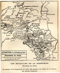
| Description |
Français : Cartes des positions des armées belge, françaises, britannique et allemandes après le recul du mois d’août, la partie ouest du front se situant sur la frontière belgo-française, le 23 août 1914, pendant la Première Guerre mondiale, d’après les informations du GQG français (pas forcément exactement la réalité donc, surtout en ce qui concerne les armées allemandes). Tirées des mémoires du maréchal Joffre, publiées à titre posthume. Référence complète : Joseph Joffre, Mémoires du Maréchal Joffre (1910-1917), tome premier, Paris : Librairie Plon, 1932 |
||||||||||||||||||||
| Date | |||||||||||||||||||||
| Source | scan personnel | ||||||||||||||||||||
| Author |
|
||||||||||||||||||||

Licensing edit
The author died in 1931, so this work is in the public domain in its country of origin and other countries and areas where the copyright term is the author's life plus 80 years or fewer. | |
| This file has been identified as being free of known restrictions under copyright law, including all related and neighboring rights. | |
File history
Click on a date/time to view the file as it appeared at that time.
| Date/Time | Thumbnail | Dimensions | User | Comment | |
|---|---|---|---|---|---|
| current | 10:28, 21 May 2010 | | 1,736 × 2,099 (8.16 MB) | K800i (talk | contribs) | {{Information |Description={{fr|1={{fr|1=Cartes des positions des armées belge, françaises, britannique et allemandes après le recul du mois d’août, la partie ouest du front se situant sur la frontière belgo-française, le 23 août 1914, pendant la |
You cannot overwrite this file.
File usage on Commons
There are no pages that use this file.