File:Gran Guerra del Norte Fase1.png

Size of this preview: 430 × 600 pixels. Other resolutions: 172 × 240 pixels | 344 × 480 pixels | 551 × 768 pixels | 734 × 1,024 pixels | 1,300 × 1,813 pixels.
Original file (1,300 × 1,813 pixels, file size: 3.48 MB, MIME type: image/png)
Captions
Captions
Add a one-line explanation of what this file represents
Summary edit
| Description |
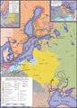
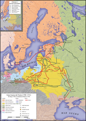
English: Map of the Great Northern War (1700–1721), Part 1 1700–1709, Map in Spanish
Deutsch: Karte des Großen Nordischen Kriegs (1700–1721), Teil 1 1700–1709, Karte in spanisch
Español: Mapa de la Gran Guerra del Norte (1700–1721), fase 1 (1700–1709), mapa en español. |
| Date | |
| Source |
|
| Author | S. Bollmann |
| Other versions |
|


Part of edit
- Gran Guerra del Norte
-
 Gran Guerra del Norte (1700–1721),
Fase 1 1700–1709 -
 Gran Guerra del Norte (1700–1721),
Fase 2 1709–1721


Licensing edit
I, the copyright holder of this work, hereby publish it under the following licenses:

|
Permission is granted to copy, distribute and/or modify this document under the terms of the GNU Free Documentation License, Version 1.2 or any later version published by the Free Software Foundation; with no Invariant Sections, no Front-Cover Texts, and no Back-Cover Texts. A copy of the license is included in the section entitled GNU Free Documentation License. |
This file is licensed under the Creative Commons Attribution-Share Alike 3.0 Unported, 2.5 Generic, 2.0 Generic and 1.0 Generic license.
- You are free:
- to share – to copy, distribute and transmit the work
- to remix – to adapt the work
- Under the following conditions:
- attribution – You must give appropriate credit, provide a link to the license, and indicate if changes were made. You may do so in any reasonable manner, but not in any way that suggests the licensor endorses you or your use.
- share alike – If you remix, transform, or build upon the material, you must distribute your contributions under the same or compatible license as the original.
You may select the license of your choice.

|
This map has been made or improved in the German Kartenwerkstatt (Map Lab). You can propose maps to improve as well.
|
File history
Click on a date/time to view the file as it appeared at that time.
| Date/Time | Thumbnail | Dimensions | User | Comment | |
|---|---|---|---|---|---|
| current | 16:51, 31 July 2022 | | 1,300 × 1,813 (3.48 MB) | S. Bollmann (talk | contribs) | name correction Karlstad -> Karlskrona |
| 21:54, 9 February 2010 |  | 1,300 × 1,813 (3.48 MB) | S. Bollmann (talk | contribs) | inverted Gulfs (Bothnia, Finlandia) corrected colour of Danish campaign 1700 corrected | |
| 11:51, 9 February 2010 |  | 1,300 × 1,813 (3.48 MB) | S. Bollmann (talk | contribs) | Height profile added | |
| 13:04, 31 December 2009 |  | 1,300 × 1,813 (1.34 MB) | S. Bollmann (talk | contribs) | {{Information |Description={{en|1=Map of the Great Northern War (1700–1721), Part 1 1700–1709, Map in Spanish}} {{de|1=Karte des Großen Nordischen Kriegs (1700–1721), Teil 1 1700–1709, Karte in spanisch}} |Source={{own}} |Author=[[User:S. Bollman |
You cannot overwrite this file.
File usage on Commons
The following 6 pages use this file:
File usage on other wikis
The following other wikis use this file:
- Usage on ast.wikipedia.org
- Usage on ca.wikipedia.org
- Usage on es.wikipedia.org
- Usage on pt.wikibooks.org