File:Gran colombia.svg

Size of this PNG preview of this SVG file: 595 × 459 pixels. Other resolutions: 311 × 240 pixels | 622 × 480 pixels | 996 × 768 pixels | 1,280 × 987 pixels | 2,560 × 1,975 pixels.
Original file (SVG file, nominally 595 × 459 pixels, file size: 216 KB)
Captions
Captions
Add a one-line explanation of what this file represents
Summary
edit
| Description |
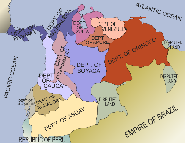
English: SVG map of Gran Colombia as it existed in 1824. |
| Date | |
| Source |
Own work based on |
| Author | Camilo Sanchez |
Licensing
edit
I, the copyright holder of this work, hereby publish it under the following licenses:
This file is licensed under the Creative Commons Attribution-Share Alike 3.0 Unported license.
- You are free:
- to share – to copy, distribute and transmit the work
- to remix – to adapt the work
- Under the following conditions:
- attribution – You must give appropriate credit, provide a link to the license, and indicate if changes were made. You may do so in any reasonable manner, but not in any way that suggests the licensor endorses you or your use.
- share alike – If you remix, transform, or build upon the material, you must distribute your contributions under the same or compatible license as the original.

|
Permission is granted to copy, distribute and/or modify this document under the terms of the GNU Free Documentation License, Version 1.2 or any later version published by the Free Software Foundation; with no Invariant Sections, no Front-Cover Texts, and no Back-Cover Texts. A copy of the license is included in the section entitled GNU Free Documentation License. |
You may select the license of your choice.
File history
Click on a date/time to view the file as it appeared at that time.
| Date/Time | Thumbnail | Dimensions | User | Comment | |
|---|---|---|---|---|---|
| current | 01:24, 28 August 2021 | | 595 × 459 (216 KB) | Milenioscuro (talk | contribs) | Reverted to version as of 12:29, 28 September 2009 (UTC) |
| 18:15, 28 May 2011 |  | 600 × 500 (146 KB) | Milenioscuro (talk | contribs) | Reverted to version as of 01:15, 4 September 2009 | |
| 19:01, 15 June 2010 |  | 2,297 × 1,870 (342 KB) | Milenioscuro (talk | contribs) | colores y borde | |
| 05:12, 20 March 2010 |  | 2,297 × 1,870 (323 KB) | Milenioscuro (talk | contribs) | font | |
| 05:09, 20 March 2010 |  | 2,297 × 1,870 (298 KB) | Milenioscuro (talk | contribs) | new map | |
| 12:29, 28 September 2009 |  | 595 × 459 (216 KB) | Milenioscuro (talk | contribs) | ajuste de los bordes | |
| 01:15, 4 September 2009 |  | 600 × 500 (146 KB) | Camilo Sanchez (talk | contribs) | {{Information |Description={{en|1=SVG map of Gran Colombia as it existed in 1824. }} |Source=Own work by uploader |Author=Camilo Sanchez |Date= |Permission= |other_versions= }} |
You cannot overwrite this file.
File usage on Commons
The following page uses this file: