File:GreenLine1967-1969.png

Size of this preview: 366 × 600 pixels. Other resolutions: 146 × 240 pixels | 293 × 480 pixels | 469 × 768 pixels | 625 × 1,024 pixels | 1,818 × 2,978 pixels.
Original file (1,818 × 2,978 pixels, file size: 2.14 MB, MIME type: image/png)
Captions
Captions
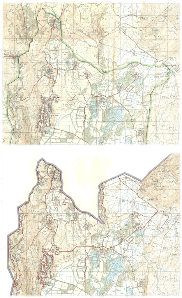
Erasure of the Green Line on official Israel maps after 1967 (Galilee pan-handle example)
Summary edit
| Description |
English: Portions of maps published by the Survey of Israel.
Top map: "Metula", 1:50,000, surveyed 1965, printed April 1967. Bottom map: "Metula", 1:50,000, surveyed 1969, printed July 1970. |
| Date | |
| Source | Hebrew University |
| Author | Survey of Israel |
Licensing edit
This work was created or ordered by the State of Israel, and is in the public domain because it satisfies one of the conditions stipulated in Israel's copyright statute from 2007 (translation) regarding the State's copyrights:
|

|
File history
Click on a date/time to view the file as it appeared at that time.
| Date/Time | Thumbnail | Dimensions | User | Comment | |
|---|---|---|---|---|---|
| current | 13:16, 15 September 2021 | | 1,818 × 2,978 (2.14 MB) | Zero0000 (talk | contribs) | Uploaded a work by Survey of Israel from Hebrew University with UploadWizard |
You cannot overwrite this file.
File usage on Commons
There are no pages that use this file.
File usage on other wikis
The following other wikis use this file:
- Usage on en.wikipedia.org
- Usage on ko.wikipedia.org