File:Henares drainage basin map-es.svg

Size of this PNG preview of this SVG file: 625 × 599 pixels. Other resolutions: 250 × 240 pixels | 501 × 480 pixels | 801 × 768 pixels | 1,068 × 1,024 pixels | 2,136 × 2,048 pixels | 725 × 695 pixels.
Original file (SVG file, nominally 725 × 695 pixels, file size: 1.11 MB)
Captions
Captions
Add a one-line explanation of what this file represents
Summary edit
| Description |
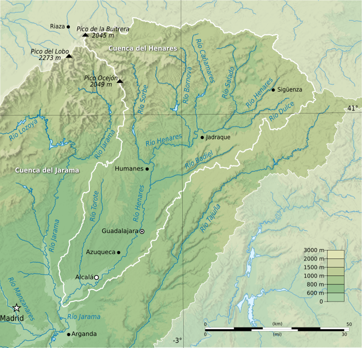
Français : Carte topographique du bassin versant de l'Henares, en Espagne.
Projection Conique Conforme de Lambert (Madrid 1870, EPSG:2062). Limites géographiques de la carte :
|
| Date | |
| Source |
This vector image includes elements that have been taken or adapted from this file: |
| Author | Flappiefh (translated by Asqueladd using svgtranslate.php) |

|
This SVG file contains embedded text that can be translated into your language, using any capable SVG editor, text editor or the SVG Translate tool. For more information see: About translating SVG files. |
Licensing edit
I, the copyright holder of this work, hereby publish it under the following license:
This file is licensed under the Creative Commons Attribution-Share Alike 3.0 Unported license.
- You are free:
- to share – to copy, distribute and transmit the work
- to remix – to adapt the work
- Under the following conditions:
- attribution – You must give appropriate credit, provide a link to the license, and indicate if changes were made. You may do so in any reasonable manner, but not in any way that suggests the licensor endorses you or your use.
- share alike – If you remix, transform, or build upon the material, you must distribute your contributions under the same or compatible license as the original.
File history
Click on a date/time to view the file as it appeared at that time.
| Date/Time | Thumbnail | Dimensions | User | Comment | |
|---|---|---|---|---|---|
| current | 23:47, 28 December 2013 | | 725 × 695 (1.11 MB) | Asqueladd (talk | contribs) | =={{int:filedesc}}== {{Information |description={{fr|1=Carte topographique du bassin versant de l'Henares, en Espagne. Projection Conique Conforme de Lambert (Madrid 1870, EPSG:2062). Limites géographiques de la carte : *N : 41.363411,-3.013 *S : 40.2... |
You cannot overwrite this file.
File usage on Commons
There are no pages that use this file.
File usage on other wikis
The following other wikis use this file:
- Usage on br.wikipedia.org
- Usage on de.wikipedia.org
- Usage on es.wikipedia.org
- Usage on hu.wikipedia.org
- Usage on ja.wikipedia.org
- Usage on sh.wikipedia.org