File:Historic American Buildings Survey, Elmer R. Pearson, Photographer, 1968 ELEVATION, LOOKING NORTHEAST. - Shaker Centre Family, Trustees' Office, Oxford Road, White Water Park, HABS OHIO,31-WHIT,2-3.tif

Size of this JPG preview of this TIF file: 750 × 599 pixels. Other resolutions: 300 × 240 pixels | 601 × 480 pixels | 961 × 768 pixels | 1,280 × 1,023 pixels | 2,560 × 2,046 pixels | 5,000 × 3,996 pixels.
Original file (5,000 × 3,996 pixels, file size: 19.06 MB, MIME type: image/tiff)
Captions
Captions
Add a one-line explanation of what this file represents
Summary edit
| Historic American Buildings Survey, Elmer R. Pearson, Photographer, 1968 ELEVATION, LOOKING NORTHEAST. - Shaker Centre Family, Trustees' Office, Oxford Road, White Water Park, Hamilton County, OH | ||||
|---|---|---|---|---|
| Title |
Historic American Buildings Survey, Elmer R. Pearson, Photographer, 1968 ELEVATION, LOOKING NORTHEAST. - Shaker Centre Family, Trustees' Office, Oxford Road, White Water Park, Hamilton County, OH |
|||
| Description |
|
|||
| Depicted place | Ohio; Hamilton County; White Water Park | |||
| Date | 1968 | |||
| Dimensions | 5 x 7 in. | |||
| Current location |
Library of Congress Prints and Photographs Division Washington, D.C. 20540 USA http://hdl.loc.gov/loc.pnp/pp.print |
|||
| Accession number |
HABS OHIO,31-WHIT,2-3 |
|||
| Credit line |
|
|||
| Notes |
|
|||
| Source | https://www.loc.gov/pictures/item/oh0029.photos.127652p | |||
| Permission (Reusing this file) |
|
|||

| Object location | | View this and other nearby images on: OpenStreetMap |
|---|
File history
Click on a date/time to view the file as it appeared at that time.
| Date/Time | Thumbnail | Dimensions | User | Comment | |
|---|---|---|---|---|---|
| current | 10:08, 30 July 2014 | 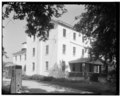 | 5,000 × 3,996 (19.06 MB) | Fæ (talk | contribs) | GWToolset: Creating mediafile for Fæ. HABS 30 July 2014 (2601:2900) |
You cannot overwrite this file.
File usage on Commons
The following page uses this file: