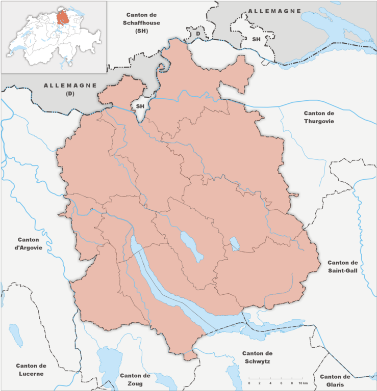
File:Karte Kanton Zürich Bezirke 2010 clair.png

Size of this preview: 577 × 599 pixels. Other resolutions: 231 × 240 pixels | 462 × 480 pixels | 739 × 768 pixels | 986 × 1,024 pixels | 2,066 × 2,146 pixels.
Original file (2,066 × 2,146 pixels, file size: 849 KB, MIME type: image/png)
Captions
Captions
Add a one-line explanation of what this file represents
Summary edit
| Description |
English: Fork from media:Karte Kanton Zürich Bezirke 2010.png for geolocalisation Français : Refonte de media:Karte Kanton Zürich Bezirke 2010.png pour géolocalisation |
| Date | |
| Source | Own work using file:Karte Kanton Zürich Bezirke 2010.png by Tschubby |
| Author | Abaddon1337 |
Licensing edit
I, the copyright holder of this work, hereby publish it under the following license:
This file is licensed under the Creative Commons Attribution-Share Alike 3.0 Unported license.
- You are free:
- to share – to copy, distribute and transmit the work
- to remix – to adapt the work
- Under the following conditions:
- attribution – You must give appropriate credit, provide a link to the license, and indicate if changes were made. You may do so in any reasonable manner, but not in any way that suggests the licensor endorses you or your use.
- share alike – If you remix, transform, or build upon the material, you must distribute your contributions under the same or compatible license as the original.
File history
Click on a date/time to view the file as it appeared at that time.
| Date/Time | Thumbnail | Dimensions | User | Comment | |
|---|---|---|---|---|---|
| current | 20:53, 5 February 2012 | | 2,066 × 2,146 (849 KB) | Abaddon1337 (talk | contribs) |
You cannot overwrite this file.
File usage on Commons
There are no pages that use this file.
File usage on other wikis
The following other wikis use this file:
- Usage on eo.wikipedia.org
- Usage on pl.wikipedia.org
- Politechnika Federalna w Zurychu
- Fraumünster
- Kościół św. Piotra w Zurychu
- Grossmünster
- Wasserkirche
- Zürich Hauptbahnhof
- Synagoga Löwenstrasse w Zurychu
- II bitwa pod Zurychem
- Port lotniczy Zurych-Kloten
- Zürich Hardbrücke
- Letzigrund Stadion
- Winterthur (stacja kolejowa)
- Bülach (stacja kolejowa)
- Hardturm
- Uniwersytet Zuryski
- Parafia Opieki Matki Bożej w Zurychu
- Hallenstadion
- Zürich Stadelhofen
- Zürich Altstetten
- Zürich Enge
- Zürich Oerlikon
- Zürich Selnau
- Zürich Tiefenbrunnen
- Zürich Wiedikon
- Zürich Wipkingen
- Stadion Schützenwiese
- Szablon:Państwo dane Zurych
- Villa Flora
- Museum Oskar Reinhart am Stadtgarten
- Museum Oskar Reinhart am Römerholz
- Schweizer Radio und Fernsehen
- Kunsthaus Zürich
- Esslingen (Szwajcaria)
- Wikipedysta:Costamagica/Dietikon
- Volkshaus
- Thalwil (stacja kolejowa)
- Dietikon (stacja kolejowa)
- FIFA Museum
- Moduł:Mapa/dane/Zurych
- Moduł:Mapa/dane/CH-ZH
- Wikipedystka:Bertra Bergamotka/Sulzer
- Ratusz w Zurychu
- Greifensee (jezioro)
- Afera korupcyjna w FIFA (2015)
- Centrum Le Corbusiera
- Prime Tower
- Kościół Reformowany w Hombrechtikon
- Usage on pl.wikibooks.org
View more global usage of this file.