File:Karte polnischeteilungen4.jpg

Size of this preview: 701 × 599 pixels. Other resolutions: 281 × 240 pixels | 562 × 480 pixels | 898 × 768 pixels | 1,198 × 1,024 pixels | 1,344 × 1,149 pixels.
Original file (1,344 × 1,149 pixels, file size: 932 KB, MIME type: image/jpeg)
Captions
Captions
Add a one-line explanation of what this file represents

|
This historical map image could be re-created using vector graphics as an SVG file. This has several advantages; see Commons:Media for cleanup for more information. If an SVG form of this image is available, please upload it and afterwards replace this template with
{{vector version available|new image name}}.
It is recommended to name the SVG file “Karte polnischeteilungen4.svg”—then the template Vector version available (or Vva) does not need the new image name parameter. |

This image was copied from wikipedia:de. The original description was:
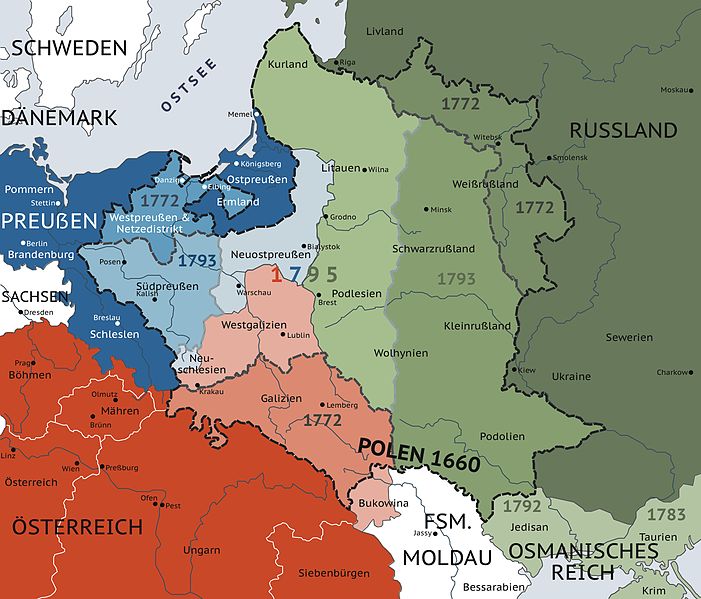
eigene Darstellung, GNU FDL, Die Teilungen Polens 1772, 1793, 1795

|
Permission is granted to copy, distribute and/or modify this document under the terms of the GNU Free Documentation License, Version 1.2 or any later version published by the Free Software Foundation; with no Invariant Sections, no Front-Cover Texts, and no Back-Cover Texts. A copy of the license is included in the section entitled GNU Free Documentation License. |
| This file is licensed under the Creative Commons Attribution-Share Alike 3.0 Unported license. | ||
| ||
| This licensing tag was added to this file as part of the GFDL licensing update. |
| date/time | username | edit summary |
|---|---|---|
| 02:14, 5. Jan 2006 | Denniss | |
| 16:18, 5. Jun 2005 | Historyk | |
| 16:22, 31. Mär 2004 | Sansculotte | (eigene Darstellung, GNU FDL, Die polnischen Teilungen 1772, 1793, 1795) |
File history
Click on a date/time to view the file as it appeared at that time.
| Date/Time | Thumbnail | Dimensions | User | Comment | |
|---|---|---|---|---|---|
| current | 07:43, 18 October 2016 | | 1,344 × 1,149 (932 KB) | Jiangkm3 (talk | contribs) | Changed ß into ẞ |
| 05:58, 15 October 2016 |  | 1,344 × 1,149 (932 KB) | Jiangkm3 (talk | contribs) | Higher Resolution | |
| 13:38, 31 December 2011 |  | 701 × 600 (232 KB) | Spiridon Ion Cepleanu (talk | contribs) | Verbesserungen nach "Westermann Grosser Atl. zur Weltgesch.", p. 119, 1985, ISBN 3-14-100919-8 und nach alle alten Karten bis 1800 : 1)- Öster.-Ungarn fängt 1867 an, bis dahin war es das Kaiserr. zu Böhmen, Mähren und Siebenbg. ; 2)- Fsm. Moldau war e | |
| 01:44, 24 February 2006 |  | 900 × 770 (125 KB) | Crux (talk | contribs) | This image was copied from wikipedia:de. The original description was: eigene Darstellung, GNU FDL, Die Teilungen Polens 1772, 1793, 1795 {{GFDL}} {| border="1" ! date/time || username || edit summary |---- | 02:14, 5. Jan 2006 || Denniss || <nowiki></ |
You cannot overwrite this file.
File usage on Commons
The following 4 pages use this file:
File usage on other wikis
The following other wikis use this file:
- Usage on et.wikipedia.org