File:Landlocked countries.png
Size of this preview: 800 × 351 pixels. Other resolutions: 320 × 140 pixels | 640 × 281 pixels | 1,425 × 625 pixels.
Original file (1,425 × 625 pixels, file size: 54 KB, MIME type: image/png)
Captions
Captions
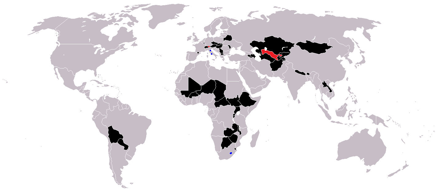
Landlocked countries

|
File:Landlocked countries.svg is a vector version of this file. It should be used in place of this PNG file when not inferior.
File:Landlocked countries.png → File:Landlocked countries.svg
For more information, see Help:SVG. |
 |
Summary edit
| Description | |
| Date | |
| Source | Own work |
| Author | Ævar Arnfjörð Bjarmason |
Countries coloured black on the map edit
Countries coloured red on the map (double landlocked) edit
Countries coloured blue on the map (landlocked by a single country) edit
Licensing edit
| I, the copyright holder of this work, release this work into the public domain. This applies worldwide. In some countries this may not be legally possible; if so: I grant anyone the right to use this work for any purpose, without any conditions, unless such conditions are required by law. |
File history
Click on a date/time to view the file as it appeared at that time.
| Date/Time | Thumbnail | Dimensions | User | Comment | |
|---|---|---|---|---|---|
| current | 12:36, 1 June 2018 | | 1,425 × 625 (54 KB) | LamBoet (talk | contribs) | Reverted to version as of 16:39, 15 July 2011 (UTC) - Restore blue color for countries that are landlocked by a single country |
| 21:34, 2 April 2018 |  | 1,425 × 625 (37 KB) | Maphobbyist (talk | contribs) | Check | |
| 21:03, 2 April 2018 |  | 1,425 × 625 (37 KB) | Maphobbyist (talk | contribs) | Black coloring for San Marino, Vatican and Lesotho. | |
| 16:39, 15 July 2011 |  | 1,425 × 625 (54 KB) | Hoshie (talk | contribs) | added South Sudan and added circles foe European microsates | |
| 13:47, 27 September 2010 |  | 1,425 × 625 (48 KB) | (지금은) 소년시대 (talk | contribs) | + Landlocked by a single country | |
| 05:33, 23 October 2008 |  | 1,425 × 625 (48 KB) | IngSoc BigBrother (talk | contribs) | ||
| 16:14, 25 February 2007 |  | 1,425 × 625 (30 KB) | Aivazovsky~commonswiki (talk | contribs) | ||
| 09:29, 23 May 2006 |  | 1,357 × 628 (46 KB) | Stefan040780 (talk | contribs) | source: same as old map, updated on 23.5.06 by stefan040780 | |
| 03:08, 21 June 2005 |  | 1,357 × 628 (25 KB) | Ævar Arnfjörð Bjarmason (talk | contribs) | Landlocked countries, based on Image:BlankMap-World.png. Category:World maps |
You cannot overwrite this file.
File usage on Commons
There are no pages that use this file.
File usage on other wikis
The following other wikis use this file:
- Usage on ckb.wikipedia.org
- Usage on da.wikipedia.org
- Usage on eu.wikipedia.org
- Usage on fa.wikipedia.org
- Usage on fo.wikipedia.org
- Usage on fr.wikipedia.org
- Usage on hr.wikipedia.org
- Usage on hu.wikipedia.org
- Usage on is.wiktionary.org
- Usage on ja.wikipedia.org
- Usage on ja.wiktionary.org
- Usage on kk.wikipedia.org
- Usage on ko.wikipedia.org
- Usage on mk.wikipedia.org
- Usage on ms.wikipedia.org
- Usage on nso.wikipedia.org
- Usage on te.wikipedia.org
- Usage on uk.wikipedia.org
- Usage on vi.wikipedia.org
- Usage on zh-yue.wikipedia.org