File:Leiden centrum.png

Size of this preview: 735 × 600 pixels. Other resolutions: 294 × 240 pixels | 588 × 480 pixels | 942 × 768 pixels | 1,102 × 899 pixels.
Original file (1,102 × 899 pixels, file size: 1.82 MB, MIME type: image/png)
Captions
Captions
Add a one-line explanation of what this file represents
Summary edit
| Description |
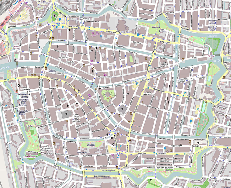
Nederlands: Kaart leiden centrum voor gebruik als positiekaart.
Geographic limits of the map: N: 52.166° S: 52.152° W: 4.480° E: 4.506° |
| Date | |
| Source | OpenStreetMap |
| Author | Biccie |
| Camera location | | View this and other nearby images on: OpenStreetMap |
|---|
Licensing edit
This file is licensed under the Creative Commons Attribution-Share Alike 2.0 Generic license.
- You are free:
- to share – to copy, distribute and transmit the work
- to remix – to adapt the work
- Under the following conditions:
- attribution – You must give appropriate credit, provide a link to the license, and indicate if changes were made. You may do so in any reasonable manner, but not in any way that suggests the licensor endorses you or your use.
- share alike – If you remix, transform, or build upon the material, you must distribute your contributions under the same or compatible license as the original.
File history
Click on a date/time to view the file as it appeared at that time.
| Date/Time | Thumbnail | Dimensions | User | Comment | |
|---|---|---|---|---|---|
| current | 10:44, 4 October 2012 | | 1,102 × 899 (1.82 MB) | Biccie (talk | contribs) | Betere uitsnede |
| 20:59, 3 October 2012 |  | 835 × 835 (1.3 MB) | Biccie (talk | contribs) | User created page with UploadWizard |
You cannot overwrite this file.
File usage on Commons
There are no pages that use this file.
File usage on other wikis
The following other wikis use this file:
- Usage on fy.wikipedia.org
- Usage on nl.wikipedia.org
- Rijksmuseum Boerhaave
- Rijksmuseum van Oudheden
- Wereldmuseum Leiden
- Hortus botanicus Leiden
- Leidse buskruitramp
- Museum De Lakenhal
- Burcht van Leiden
- Koornbrug
- De Valk (Leiden)
- Visbrug (Leiden)
- Japanmuseum SieboldHuis
- Binnenstad (Leiden)
- Oude Sterrewacht
- Trianon Theater
- Van der Werfpark
- Morspoortbrug
- Rembrandtbrug
- Dullebrug
- Kerkbrug (Leiden)
- Kerkpleinbrug
- Lourisbrug
- Herenbrug (Leiden)
- Karnemelksbrug
- Scheluwbrug
- Kleine Havenbrug
- Weverbrug
- Bostelbrug
- Leiden American Pilgrim Museum
- Plantsoen (Leiden)
- Blauwpoortsbrug (Leiden)
- Sint Jansbrug (Leiden)
- Vreewijkbrug
- Huize Vreewijk
- Paterbrug
- Neksluisbrug
- Reuvensbrug
- Rijnsburgerbrug
- Wittepoortsbrug
- Jan van Houtbrug
- Kippenbrug (Leiden)
- Sjabloon:Positiekaart Leiden-centrum
- Christelijke Jongelingsvereniging Prediker 12:1a
- Nonnenbrug
- Ankerpark
- Blekerspark
- Huigpark
- Katoenpark
- Museum Het Leids Wevershuis
- Koepoortsbrug
View more global usage of this file.