File:Lived Here. Benjamin Franklin printer, philosopher and statesman Born 1706. Died 1790.jpg

Size of this preview: 450 × 600 pixels. Other resolutions: 180 × 240 pixels | 360 × 480 pixels | 576 × 768 pixels | 768 × 1,024 pixels | 1,536 × 2,048 pixels | 3,000 × 4,000 pixels.
Original file (3,000 × 4,000 pixels, file size: 2.67 MB, MIME type: image/jpeg)
Captions
Captions
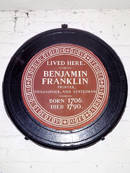
Lived Here. Benjamin Franklin printer, philosopher and statesman Born 1706. Died 1790
Summary edit
| Description |
English: Brown plaque originally erected at 7 Craven Street by the Society of Arts in 1869.
Benjamin Franklin was known to have lived at 7 Craven Street during his sixteen years in London and this address was an early recipient of a commemorative plaque from the 'official' London-wide plaque scheme. In 1903, research by Sir Laurence Gomme of London County Council revealed that the house was not in fact the former Franklin residence - comparison of rate books and street directories revealing that Franklin's lodgings had been renumbered twice in the intervening years and what had been No.7 in his time survived as No.36. The truth came to light in 1913 when attempts were being made to save No.7 from redevelopment due to its supposed historical significance and the Society of Arts was forced to admit its mistake. The LCC erected a bronze 'medallion style' plaque at No.36 in 1914 and for a time, before No.7 was demolished, the two plaques stood on opposite sides of the street, no doubt leading to some confusion. In the 20th century No.36 was used as a hotel, then as a base for several non-profit groups (and was for a time occupied by squatters), but was in dire condition at the end of the century when the freehold was granted to the Friends of Benjamin Franklin House by the UK government. Following structural reinforcement and restoration the house opened as a museum on 17th January 2006, the 300th anniversary of Franklin's birth. The SOA plaque from the long-lost, No.7 which had been for many years in the possession of the Museum of London, was presented to the Friends of Benjamin Franklin House and is on display in the basement corridor. |
| Date | |
| Source | Own work |
| Author | Spudgun67 |
| Camera location | | View this and other nearby images on: OpenStreetMap |
|---|
Licensing edit
I, the copyright holder of this work, hereby publish it under the following license:
This file is licensed under the Creative Commons Attribution-Share Alike 4.0 International license.
- You are free:
- to share – to copy, distribute and transmit the work
- to remix – to adapt the work
- Under the following conditions:
- attribution – You must give appropriate credit, provide a link to the license, and indicate if changes were made. You may do so in any reasonable manner, but not in any way that suggests the licensor endorses you or your use.
- share alike – If you remix, transform, or build upon the material, you must distribute your contributions under the same or compatible license as the original.
File history
Click on a date/time to view the file as it appeared at that time.
| Date/Time | Thumbnail | Dimensions | User | Comment | |
|---|---|---|---|---|---|
| current | 17:26, 17 October 2020 | | 3,000 × 4,000 (2.67 MB) | Spudgun67 (talk | contribs) | Uploaded own work with UploadWizard |
You cannot overwrite this file.
File usage on Commons
The following page uses this file:
.jpg&redirect=no)
File usage on other wikis
The following other wikis use this file:
- Usage on en.wikipedia.org