File:Location ConfederaciónPerú-Boliviana.png
No higher resolution available.
Location_ConfederaciónPerú-Boliviana.png (250 × 122 pixels, file size: 6 KB, MIME type: image/png)
Captions
Captions
Add a one-line explanation of what this file represents
Summary edit
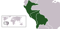
 Ubicación de la Confederación Perú-Boliviana.
 Location map of Peru-Bolivian Confederacy.
Licensing edit
I, the copyright holder of this work, hereby publish it under the following license:

|
Permission is granted to copy, distribute and/or modify this document under the terms of the GNU Free Documentation License, Version 1.2 or any later version published by the Free Software Foundation; with no Invariant Sections, no Front-Cover Texts, and no Back-Cover Texts. A copy of the license is included in the section entitled GNU Free Documentation License. |
| This file is licensed under the Creative Commons Attribution-Share Alike 3.0 Unported license. | ||
| ||
| This licensing tag was added to this file as part of the GFDL licensing update. |
File history
Click on a date/time to view the file as it appeared at that time.
| Date/Time | Thumbnail | Dimensions | User | Comment | |
|---|---|---|---|---|---|
| current | 21:41, 10 May 2014 | | 250 × 122 (6 KB) | Edubucher (talk | contribs) | Restituyendo mapa de edición vandalica |
| 23:02, 24 January 2012 |  | 250 × 122 (4 KB) | David C. S. (talk | contribs) | El oriente ecuatoriano no formó parte de la confederación | |
| 02:10, 16 December 2011 |  | 250 × 122 (6 KB) | Edubucher (talk | contribs) | Restituyendo mapa de edición vandalica | |
| 15:33, 25 February 2011 |  | 250 × 122 (4 KB) | David C. S. (talk | contribs) | Territorio | |
| 11:52, 9 September 2006 |  | 250 × 122 (6 KB) | Conscious (talk | contribs) | Reverted to earlier revision | |
| 11:51, 9 September 2006 |  | 250 × 122 (5 KB) | Conscious (talk | contribs) | version from en:, by en:User:RapaNui, GFDL | |
| 00:32, 12 March 2006 |  | 250 × 122 (6 KB) | ThrashedParanoid~commonswiki (talk | contribs) | Fixed the lines | |
| 21:20, 1 February 2006 |  | 250 × 122 (5 KB) | Huhsunqu (talk | contribs) | ||
| 17:18, 12 June 2005 |  | 250 × 122 (5 KB) | Huhsunqu (talk | contribs) | 250px version | |
| 17:06, 12 June 2005 |  | 281 × 122 (5 KB) | Huhsunqu (talk | contribs) | {{es icon}} Ubicación de la Confederación Perú-Boliviana. {{en icon}} Location map of Peru-Bolivian Confederacy. {{GFDL-self}} Category:Maps of South America |
You cannot overwrite this file.
File usage on Commons
There are no pages that use this file.