File:Map - Special Collections University of Amsterdam - OTM- HB-KZL 31-06-09.tif

Size of this JPG preview of this TIF file: 710 × 600 pixels. Other resolutions: 284 × 240 pixels | 569 × 480 pixels | 910 × 768 pixels | 1,213 × 1,024 pixels | 2,425 × 2,048 pixels | 7,520 × 6,350 pixels.
Original file (7,520 × 6,350 pixels, file size: 136.62 MB, MIME type: image/tiff)
Captions
Captions
Add a one-line explanation of what this file represents
Summary edit
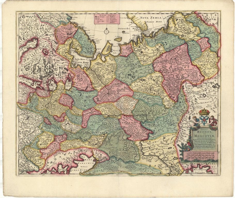
| Imperii Russici, sive Moscoviæ status generalis in ejus regna, ducatus, provincias populosque subjacentes divisus / et ex tabula spectat.mi domini N. Witsen ... pro maiori parte excerptus per F. de Witt Amst
( |
|||||||||||||||||||||||||||
|---|---|---|---|---|---|---|---|---|---|---|---|---|---|---|---|---|---|---|---|---|---|---|---|---|---|---|---|
| Author |
Frederick de Wit (1630-1706)
|
||||||||||||||||||||||||||
| Title |
Imperii Russici, sive Moscoviæ status generalis in ejus regna, ducatus, provincias populosque subjacentes divisus / et ex tabula spectat.mi domini N. Witsen ... pro maiori parte excerptus per F. de Witt Amst |
||||||||||||||||||||||||||
| Date | [after 1688] | ||||||||||||||||||||||||||
| Medium | Copperplate print | ||||||||||||||||||||||||||
| Dimensions | height: 44.5 cm (17.5 in); width: 55.5 cm (21.8 in) | ||||||||||||||||||||||||||
| Collection |
|
||||||||||||||||||||||||||
| Accession number |
OTM: HB-KZL 31-06-09 |
||||||||||||||||||||||||||
| Place of creation | Amsterdam, [published and] printed by Frederik de Wit (1654-1668) | ||||||||||||||||||||||||||
| Notes | This object is part of the collection of the Koninklijk Nederlands Aardrijkskundig Genootschap (KNAG) | ||||||||||||||||||||||||||
| Source/Photographer |
|
||||||||||||||||||||||||||
| Permission (Reusing this file) |
|
||||||||||||||||||||||||||
_-_SK-A-5016_-_Rijksmuseum.jpg)

[[Category:]Map collection Frederik Muller & Co]]
File history
Click on a date/time to view the file as it appeared at that time.
| Date/Time | Thumbnail | Dimensions | User | Comment | |
|---|---|---|---|---|---|
| current | 13:19, 20 March 2018 |  | 7,520 × 6,350 (136.62 MB) | DeJong2332 (talk | contribs) | pattypan 18.02 |
You cannot overwrite this file.
File usage on Commons
The following page uses this file:
File usage on other wikis
The following other wikis use this file:
- Usage on ru.wikipedia.org