File:Map - Special Collections University of Amsterdam - OTM- HB-KZL 33.31.29.tiff

Size of this JPG preview of this TIF file: 713 × 600 pixels. Other resolutions: 286 × 240 pixels | 571 × 480 pixels | 913 × 768 pixels | 1,218 × 1,024 pixels | 2,436 × 2,048 pixels | 7,371 × 6,198 pixels.
Original file (7,371 × 6,198 pixels, file size: 130.71 MB, MIME type: image/tiff)
Captions
Captions
Add a one-line explanation of what this file represents
Summary edit
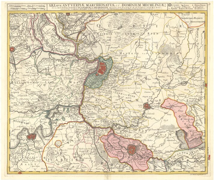
| S[acri] R[omani] I[mperii] sive Antverpiæ marchionatus et dominium Mechliniæ : cum orientalioribus Flandriæ; et Brabantiæ hisce consequentibus terminis / auctore Carolo Allard ; A: Allard integrum fecit acu
( |
|||||||||||||||||||||||||||
|---|---|---|---|---|---|---|---|---|---|---|---|---|---|---|---|---|---|---|---|---|---|---|---|---|---|---|---|
| Author |
|
||||||||||||||||||||||||||
| Title |
S[acri] R[omani] I[mperii] sive Antverpiæ marchionatus et dominium Mechliniæ : cum orientalioribus Flandriæ; et Brabantiæ hisce consequentibus terminis / auctore Carolo Allard ; A: Allard integrum fecit acu |
||||||||||||||||||||||||||
| Description |
Scale: [ca. 1:100.000] |
||||||||||||||||||||||||||
| Medium | Copperplate print | ||||||||||||||||||||||||||
| Dimensions | height: 50 cm (19.6 in); width: 59 cm (23.2 in) | ||||||||||||||||||||||||||
| Collection |
|
||||||||||||||||||||||||||
| Accession number |
OTM: HB-KZL 33.31.29 |
||||||||||||||||||||||||||
| Place of creation | Amsterdam, printed by Carel Allard (1673-1708) | ||||||||||||||||||||||||||
| Notes | This object is part of the collection of the Koninklijk Nederlands Aardrijkskundig Genootschap (KNAG) | ||||||||||||||||||||||||||
| Source/Photographer | Catalogue Library of the University of Amsterdam | ||||||||||||||||||||||||||
| Permission (Reusing this file) |
|
||||||||||||||||||||||||||
| Other versions |
|
||||||||||||||||||||||||||


File history
Click on a date/time to view the file as it appeared at that time.
| Date/Time | Thumbnail | Dimensions | User | Comment | |
|---|---|---|---|---|---|
| current | 09:45, 23 February 2018 |  | 7,371 × 6,198 (130.71 MB) | DeJong2332 (talk | contribs) | User created page with UploadWizard |
You cannot overwrite this file.
File usage on Commons
The following 3 pages use this file:
- File:Map - Special Collections University of Amsterdam - OTM- HB-KZL 33.31.29.tiff
- File:Map of Antwerp and Mechelen – Print - Special Collections University of Amsterdam - HB-KZL 33.31.29.tif (file redirect)
- File:The Holy Roman Empires Duchy of Antwerp and the Dominium of Malines- With the Eastern Flemish Areas and the Boundaries of Brabant Following from These WDL1102.png
File usage on other wikis
The following other wikis use this file:
- Usage on en.wikipedia.org