File:Meadowbrook Farm, Slifer Log Kitchen, 2655 Slifer Valley Road, Springtown, Bucks County, PA HABS PA,9-SPRITO.V,3- (sheet 2 of 6).tif

Size of this JPG preview of this TIF file: 800 × 533 pixels. Other resolutions: 320 × 213 pixels | 640 × 427 pixels | 1,024 × 682 pixels | 1,280 × 853 pixels | 2,560 × 1,706 pixels | 14,452 × 9,632 pixels.
Original file (14,452 × 9,632 pixels, file size: 898 KB, MIME type: image/tiff)
Captions
Captions
Add a one-line explanation of what this file represents
Summary edit
| Warning | The original file is very high-resolution. It might not load properly or could cause your browser to freeze when opened at full size. |
|---|
| HABS PA,9-SPRITO.V,3- (sheet 2 of 6) - Meadowbrook Farm, Slifer Log Kitchen, 2655 Slifer Valley Road, Springtown, Bucks County, PA | ||||
|---|---|---|---|---|
| Title |
HABS PA,9-SPRITO.V,3- (sheet 2 of 6) - Meadowbrook Farm, Slifer Log Kitchen, 2655 Slifer Valley Road, Springtown, Bucks County, PA |
|||
| Description |
Slifer, Jacob; Mease, Donald; Mease, Kenneth; Green, Richard L, faculty sponsor; Auerbach, Kathryn Ann, faculty sponsor; Rosenberger, Lyle, faculty sponsor; Bucks County Community College, sponsor; Upper Bucks Vocational Technical School, sponsor; Doyle, M Scott, delineator; Jordan, David G, delineator; Steigerwalt, Nancy J, delineator; Howard, Sunny R, delineator; Marek, Catherine L, delineator; Graeter-Reardon, Beatrice V, delineator; Green, Margaret, photographer |
|||
| Depicted place | Pennsylvania; Bucks County; Springtown | |||
| Date | Documentation compiled after 1933 | |||
| Dimensions | 24 x 36 in. (D size) | |||
| Current location |
Library of Congress Prints and Photographs Division Washington, D.C. 20540 USA http://hdl.loc.gov/loc.pnp/pp.print |
|||
| Accession number |
HABS PA,9-SPRITO.V,3- (sheet 2 of 6) |
|||
| Credit line |
|
|||
| Notes |
|
|||
| Source | https://www.loc.gov/pictures/item/pa3562.sheet.00002a | |||
| Permission (Reusing this file) |
|
|||

| Object location | | View this and other nearby images on: OpenStreetMap |
|---|
File history
Click on a date/time to view the file as it appeared at that time.
| Date/Time | Thumbnail | Dimensions | User | Comment | |
|---|---|---|---|---|---|
| current | 03:42, 1 August 2014 | 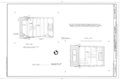 | 14,452 × 9,632 (898 KB) | Fæ (talk | contribs) | GWToolset: Creating mediafile for Fæ. HABS 31 July 2014 (3000:3200) |
You cannot overwrite this file.
File usage on Commons
The following page uses this file: