File:ND Hangquellmoor und Kalkflachmoor südöstlich Bermoos Amtsblatt.jpg

Size of this preview: 424 × 600 pixels. Other resolutions: 170 × 240 pixels | 339 × 480 pixels | 937 × 1,325 pixels.
Original file (937 × 1,325 pixels, file size: 392 KB, MIME type: image/jpeg)
Captions
Captions
Add a one-line explanation of what this file represents
Summary edit
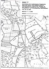
| Description | ND Hangquellmoor und Kalkflachmoor südöstlich Bermoos, Lageplan der Verordnung, ND-00111 |
| Date | |
| Source | Amtsblatt Lkr. Traunstein, 09. Januar 1981 |
| Author | Landratsamt Traunstein |
| Permission (Reusing this file) |
gemeinfrei |
| Camera location | | View this and other nearby images on: OpenStreetMap |
|---|
| This image is in the public domain according to German copyright law because it is part of a statute, ordinance, official decree or judgment (official work) issued by a German authority or court (§ 5 Abs.1 UrhG).
|
 |
File history
Click on a date/time to view the file as it appeared at that time.
| Date/Time | Thumbnail | Dimensions | User | Comment | |
|---|---|---|---|---|---|
| current | 19:21, 10 March 2024 | | 937 × 1,325 (392 KB) | Perchtinger (talk | contribs) | == {{int:filedesc}} == {{Information |Description=ND Hangquellmoor und Kalkflachmoor südöstlich Bermoos, Lageplan der Verordnung, ND-00111 |Source=Amtsblatt Lkr. Traunstein, 09. Januar 1981 |Date=1980-12-30 |Author= Landratsamt Traunstein |Permission=gemeinfrei |other_versions= }} {{Location|47.99119|12.70207|region:DE-BY}} {{PD-GermanGov}} Category:Natural monuments in Landkreis Traunstein Category:Taching am See |
You cannot overwrite this file.
File usage on Commons
The following 2 pages use this file:
File usage on other wikis
The following other wikis use this file:
- Usage on de.wikipedia.org
- Usage on www.wikidata.org