File:New bridge over the railway, Muir of Ord (geograph 5327545).jpg

Size of this preview: 800 × 580 pixels. Other resolutions: 320 × 232 pixels | 640 × 464 pixels | 1,024 × 742 pixels | 1,280 × 928 pixels | 2,560 × 1,855 pixels | 3,000 × 2,174 pixels.
Original file (3,000 × 2,174 pixels, file size: 2.25 MB, MIME type: image/jpeg)
Captions
Captions
Add a one-line explanation of what this file represents
Summary edit
.jpg&action=edit§ion=1)
| Description |
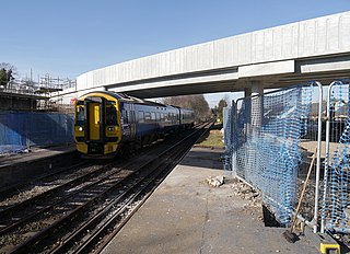
English: New bridge over the railway, Muir of Ord
The new bridge is in place and the old bridge was removed a couple of days ago. Still a fence up at the end of the platform, some work going on to tidy up. The train from Kyle of Lochalsh to Inverness is arriving at the station. It is a ScotRail Class 158, number 158719. |
| Date | |
| Source | From geograph.org.uk |
| Author | Craig Wallace |
| Permission (Reusing this file) |
Creative Commons Attribution Share-alike license 2.0 |
| Attribution (required by the license) | Craig Wallace / New bridge over the railway, Muir of Ord / |
| Camera location | | View this and other nearby images on: OpenStreetMap |
|---|
.jpg¶ms=057.517909_N_-004.460220_E_globe:Earth_type:camera_source:geograph-osgb36(NH5274350196)_heading:0.00&language=en)
| Object location | | View this and other nearby images on: OpenStreetMap |
|---|
.jpg¶ms=057.518030_N_-004.460450_E_globe:Earth_class:object_type:object_source:geograph-osgb36(NH52735021)_heading:0.00&language=en)
Licensing edit
.jpg&action=edit§ion=2)

|
This image was taken from the Geograph project collection. See this photograph's page on the Geograph website for the photographer's contact details. The copyright on this image is owned by Craig Wallace and is licensed for reuse under the Creative Commons Attribution-ShareAlike 2.0 license.
|
This file is licensed under the Creative Commons Attribution-Share Alike 2.0 Generic license.
Attribution: Craig Wallace
- You are free:
- to share – to copy, distribute and transmit the work
- to remix – to adapt the work
- Under the following conditions:
- attribution – You must give appropriate credit, provide a link to the license, and indicate if changes were made. You may do so in any reasonable manner, but not in any way that suggests the licensor endorses you or your use.
- share alike – If you remix, transform, or build upon the material, you must distribute your contributions under the same or compatible license as the original.
File history
Click on a date/time to view the file as it appeared at that time.
| Date/Time | Thumbnail | Dimensions | User | Comment | |
|---|---|---|---|---|---|
| current | 18:39, 6 December 2019 | | 3,000 × 2,174 (2.25 MB) | Salen9 (talk | contribs) | Transferred from geograph.co.uk using [https://tools.wmflabs.org/geograph2commons/ geograph2commons] |
You cannot overwrite this file.
File usage on Commons
The following page uses this file:
.jpg&oldid=852805840)