File:POLSKA woj pow gminy.png
Size of this preview: 646 × 600 pixels. Other resolutions: 259 × 240 pixels | 517 × 480 pixels | 827 × 768 pixels | 1,103 × 1,024 pixels | 2,041 × 1,895 pixels.
Original file (2,041 × 1,895 pixels, file size: 1.6 MB, MIME type: image/png)
Captions
Captions
Add a one-line explanation of what this file represents

|
This locator map image could be re-created using vector graphics as an SVG file. This has several advantages; see Commons:Media for cleanup for more information. If an SVG form of this image is available, please upload it and afterwards replace this template with
{{vector version available|new image name}}.
It is recommended to name the SVG file “POLSKA woj pow gminy.svg”—then the template Vector version available (or Vva) does not need the new image name parameter. |
Summary edit
| Description |
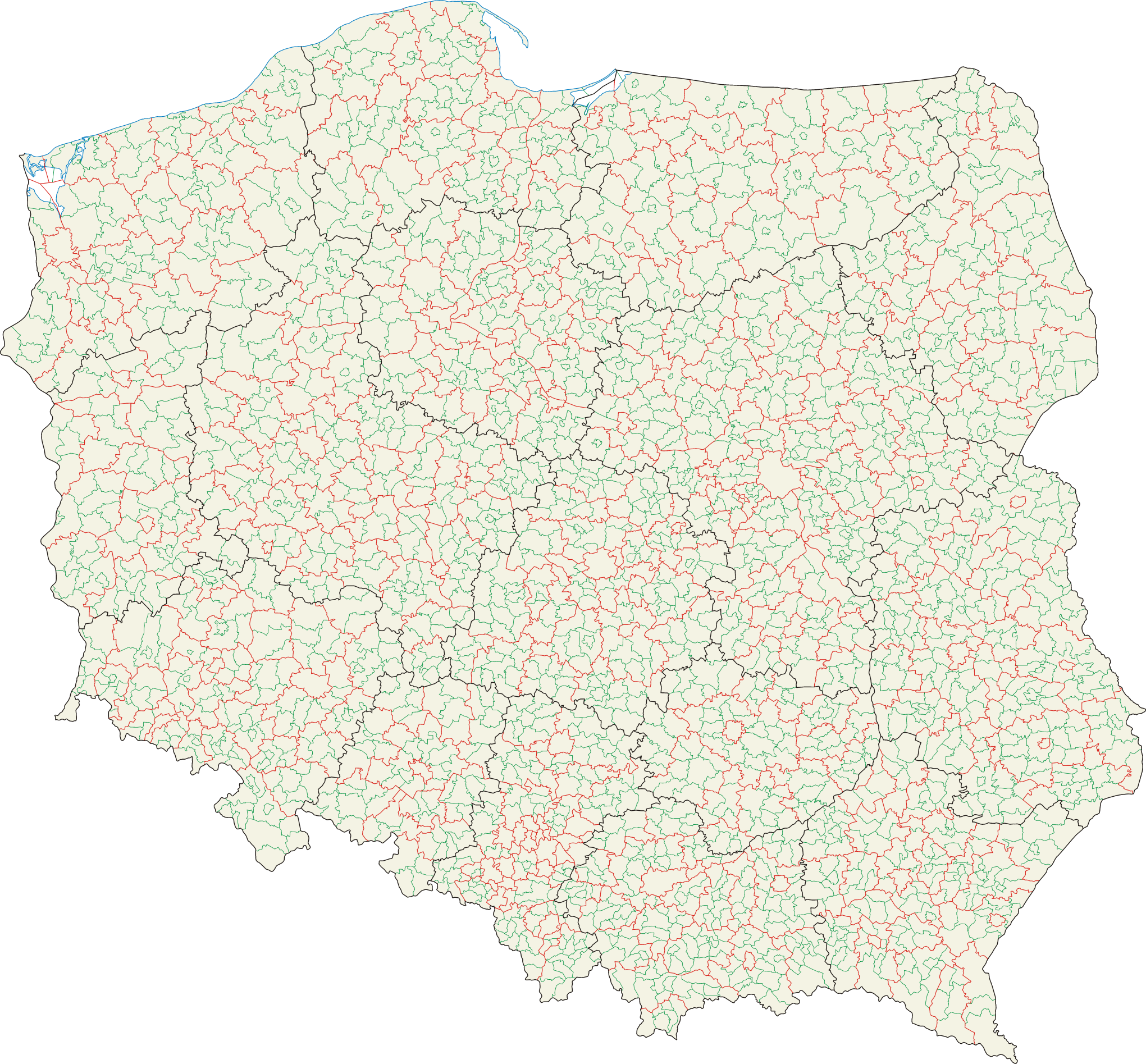
Polski: Mapa administracyjna Polski z zaznaczonymi granicami województw (na czarno), powiatów (na czerwono) i gmin (na zielono), stan na 1 stycznia 2008 English: Administrative map of Poland with borders of voievodships (black), counties (red) and communes (green), as of January 1, 2008 |
||||||||
| Date | 2007-02-01, updated=2008-04-10 | ||||||||
| Source | Self-made, based on Administrative Map of Poland 1:500,000 published by Head Office of Geodesy and Cartography with actualization | ||||||||
| Author | Aotearoa | ||||||||
| Permission (Reusing this file) |
I, the copyright holder of this work, hereby publish it under the following licenses:
This file is licensed under the Creative Commons Attribution 2.5 Generic license.
You may select the license of your choice. |

File history
Click on a date/time to view the file as it appeared at that time.
| Date/Time | Thumbnail | Dimensions | User | Comment | |
|---|---|---|---|---|---|
| current | 17:36, 25 January 2016 | | 2,041 × 1,895 (1.6 MB) | Aotearoa (talk | contribs) | drobna korekta (uzupełnienie przerwanych granic) |
| 14:41, 21 March 2015 |  | 2,041 × 1,895 (1.71 MB) | Aotearoa (talk | contribs) | Mapa przedstawia stan na 2008 rok, a wtedy Wałbrzych nie był wydzielony | |
| 14:18, 20 March 2015 |  | 2,041 × 1,895 (1.69 MB) | Blackfish (talk | contribs) | Wałbrzych | |
| 10:12, 19 May 2009 |  | 2,041 × 1,895 (1.71 MB) | Aotearoa (talk | contribs) | drobna korekta | |
| 07:20, 10 April 2008 |  | 2,041 × 1,895 (1.6 MB) | Aotearoa (talk | contribs) | ||
| 20:35, 5 February 2007 |  | 2,041 × 1,895 (1.71 MB) | Aotearoa (talk | contribs) | ||
| 18:34, 5 February 2007 |  | 2,041 × 1,895 (1.73 MB) | Aotearoa (talk | contribs) | Mapa administracyjna Polski z zaznaczonymi granicami województw, gmin i powiatów. Autor: Aotearoa<br> Administrative map of Poland with borders of województwa (voivodships), powiaty (counties) and gminy (communes). By [[User:Aotearoa| |
You cannot overwrite this file.
File usage on Commons
The following 2 pages use this file:
File usage on other wikis
The following other wikis use this file:
- Usage on ar.wikipedia.org
- Usage on be-tarask.wikipedia.org
- Usage on be.wikipedia.org
- Usage on bxr.wikipedia.org
- Usage on de.wikipedia.org
- Usage on en.wikipedia.org
- Usage on eo.wikipedia.org
- Usage on et.wikipedia.org
- Usage on fr.wikipedia.org
- Usage on hu.wikipedia.org
- Usage on hy.wikipedia.org
- Usage on ky.wikipedia.org
- Usage on ltg.wikipedia.org
- Usage on lt.wikipedia.org
- Usage on lv.wikipedia.org
- Usage on pl.wikipedia.org
- Usage on pt.wikipedia.org
- Usage on ru.wikipedia.org
- Usage on xmf.wikipedia.org