File:Plan of building lots belonging to Benjamin Brewster situated between the Lachine Canal and Lachine T.P. Road, Montreal (IA McGillLibrary-rbsc lachine canal G3454 M65 1847 O87-16681).pdf

Size of this JPG preview of this PDF file: 800 × 593 pixels. Other resolutions: 320 × 237 pixels | 640 × 475 pixels | 1,024 × 759 pixels | 1,280 × 949 pixels | 2,560 × 1,898 pixels | 6,660 × 4,939 pixels.
Original file (6,660 × 4,939 pixels, file size: 28.13 MB, MIME type: application/pdf)
Captions
Captions
Add a one-line explanation of what this file represents
Summary edit
| Author |
|
| Title |
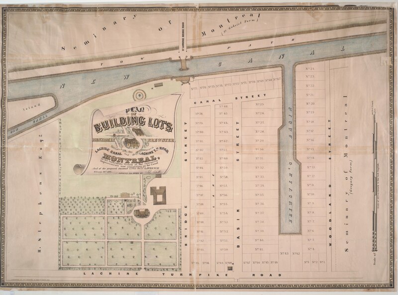
Plan of building lots belonging to Benjamin Brewster situated between the Lachine Canal and Lachine T.P. Road, Montreal, in the immediate vicinity of the extensive improvements now completing on the Canal, and of the proposed bridge across the St. Lawrence |
| Description |
Subjects: Real property -- Québec (Province) -- Montréal -- Maps.; Montréal (Québec) -- Maps.; McGill University Library Digitized Title; Montreal Maps Project; Real property |
| Language | English |
| Publication date | 1847 |
| Current location |
IA Collections: mcgilluniversity; mcgilluniversityrarebooks; toronto |
| Accession number |
McGillLibrary-rbsc_lachine_canal_G3454_M65_1847_O87-16681 |
| Source |
Licensing edit
|
This work is in the public domain in its country of origin and other countries and areas where the copyright term is the author's life plus 100 years or fewer. This work is in the public domain in the United States because it was published (or registered with the U.S. Copyright Office) before January 1, 1929. | |
| This file has been identified as being free of known restrictions under copyright law, including all related and neighboring rights. | |
File history
Click on a date/time to view the file as it appeared at that time.
| Date/Time | Thumbnail | Dimensions | User | Comment | |
|---|---|---|---|---|---|
| current | 16:13, 1 January 2021 |  | 6,660 × 4,939 (28.13 MB) | Fæ (talk | contribs) | IA Query "subject:maps date:[1000 TO 1869] " McGillLibrary-rbsc_lachine_canal_G3454_M65_1847_O87-16681 Category:Old maps (COM:IA books#query) (1847 #212) |
You cannot overwrite this file.
File usage on Commons
The following page uses this file: