File:Pont Treseli (geograph 7029155).jpg

Size of this preview: 800 × 600 pixels. Other resolutions: 320 × 240 pixels | 640 × 480 pixels | 1,024 × 768 pixels.
Original file (1,024 × 768 pixels, file size: 264 KB, MIME type: image/jpeg)
Captions
Captions
Add a one-line explanation of what this file represents
Summary edit
.jpg&action=edit§ion=1)
| Description |
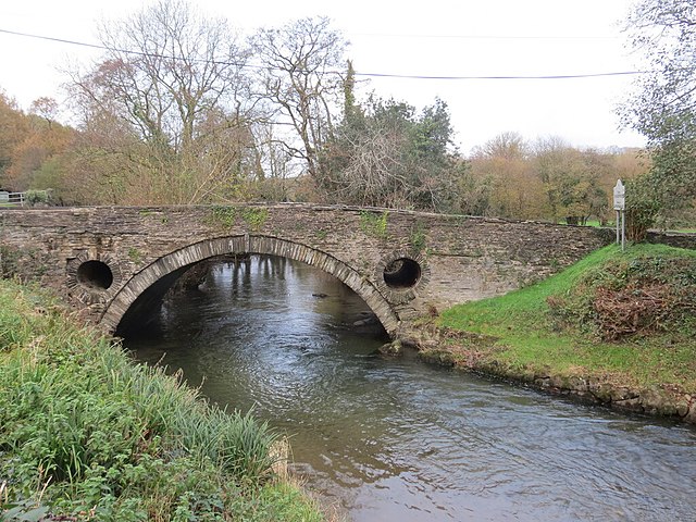
English: Pont Treseli
Adeiladwyd Pont Treseli yn ystod y 18g hwyr neu'r 19g gynnar dros Afon Cych. Mae'r afon yn pennu ffin Sir Benfro a Sir Gaerfyrddin. Yn y lleoliad hwn yn ystod y 1950au y lladdwyd llygoden fawr enfawr gan dafarnwr y Nags Head gerllaw. Darganfuwyd taw coypu ydoedd ond dirgelwch llwyr oedd sut y daeth hi i fod yn yr ardal. Cafodd y greadur ei stwffio a chael ei harddangos yn y tafarn ac yno y mae hi wedi bod ers hynny. Pont Treseli dates from the late 18th or early 19th century and spans Afon Cych. The river acts also as the boundary between Pembrokeshire and Carmarthenshire. During the 1950s a huge rat was killed at this location by the publican of the adjacent Nags Head. The rodent was later identified as a coypu but how it came to be in the area was a complete mystery. The animal was stuffed and put on display in the pub where it remains to this day. |
| Date | |
| Source | From geograph.org.uk |
| Author | Alan Richards |
| Permission (Reusing this file) |
Creative Commons Attribution Share-alike license 2.0 |
| Attribution (required by the license) | Alan Richards / Pont Treseli / |
| Camera location | | View this and other nearby images on: OpenStreetMap |
|---|
.jpg¶ms=052.030836_N_-004.551416_E_globe:Earth_type:camera_source:geograph-osgb36(SN25074001)_heading:22.00&language=en)
| Object location | | View this and other nearby images on: OpenStreetMap |
|---|
.jpg¶ms=052.031110_N_-004.551290_E_globe:Earth_class:object_type:object_source:geograph-osgb36(SN25084004)_heading:22.00&language=en)
Licensing edit
.jpg&action=edit§ion=2)

|
This image was taken from the Geograph project collection. See this photograph's page on the Geograph website for the photographer's contact details. The copyright on this image is owned by Alan Richards and is licensed for reuse under the Creative Commons Attribution-ShareAlike 2.0 license.
|
This file is licensed under the Creative Commons Attribution-Share Alike 2.0 Generic license.
Attribution: Alan Richards
- You are free:
- to share – to copy, distribute and transmit the work
- to remix – to adapt the work
- Under the following conditions:
- attribution – You must give appropriate credit, provide a link to the license, and indicate if changes were made. You may do so in any reasonable manner, but not in any way that suggests the licensor endorses you or your use.
- share alike – If you remix, transform, or build upon the material, you must distribute your contributions under the same or compatible license as the original.
File history
Click on a date/time to view the file as it appeared at that time.
| Date/Time | Thumbnail | Dimensions | User | Comment | |
|---|---|---|---|---|---|
| current | 18:16, 1 December 2021 | | 1,024 × 768 (264 KB) | Salen9 (talk | contribs) | == {{int:filedesc}} == {{Information |Description={{en|1=Pont Treseli}} |Source=From [https://www.geograph.org.uk/photo/7029155 geograph.org.uk] |Date=2021-11-24 |Author=[https://www.geograph.org.uk/profile/48504 Alan Richards] |Permission=Creative Commons Attribution Share-alike license 2.0 |Other fields={{Credit line |Author=Alan Richards |License=[https://creativecommons.org/licenses/by-sa/2.0/ CC BY-SA 2.0] |Other=''Pont Treseli'' }} }} {{Location|52.030836|-4.551416|source:geograph-o... |
You cannot overwrite this file.
File usage on Commons
There are no pages that use this file.
.jpg&oldid=801231967)