File:Ponte de João Gomes from Jardim Botanico da Madeira Engenheiro Rui Vieira, Santa Maria Maior, Funchal, Madeira, 2023 May.jpg

Size of this preview: 800 × 545 pixels. Other resolutions: 320 × 218 pixels | 640 × 436 pixels | 1,024 × 697 pixels | 1,280 × 871 pixels | 2,560 × 1,743 pixels | 4,200 × 2,859 pixels.
Original file (4,200 × 2,859 pixels, file size: 14.12 MB, MIME type: image/jpeg)
Captions
Captions
Add a one-line explanation of what this file represents
Summary edit
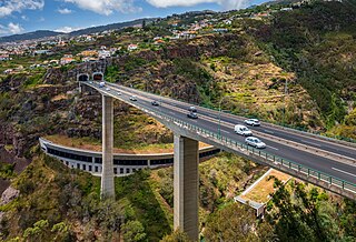
| Description | The highway bridge Ponte de João Gomes as seen from Jardim Botanico da Madeira Engenheiro Rui Vieira in Santa Maria Maior, Funchal, Madeira in 2023 May. |
| Date | |
| Source | Own work |
| Author | Ximonic (Simo Räsänen) |
| Camera location | | View this and other nearby images on: OpenStreetMap |
|---|
This file was uploaded with VicuñaUploader.
Licensing edit
This file is licensed under the Creative Commons Attribution-Share Alike 4.0 International license.
Attribution: Simo Räsänen
- You are free:
- to share – to copy, distribute and transmit the work
- to remix – to adapt the work
- Under the following conditions:
- attribution – You must give appropriate credit, provide a link to the license, and indicate if changes were made. You may do so in any reasonable manner, but not in any way that suggests the licensor endorses you or your use.
- share alike – If you remix, transform, or build upon the material, you must distribute your contributions under the same or compatible license as the original.
File history
Click on a date/time to view the file as it appeared at that time.
| Date/Time | Thumbnail | Dimensions | User | Comment | |
|---|---|---|---|---|---|
| current | 08:43, 16 March 2024 | | 4,200 × 2,859 (14.12 MB) | Ximonic (talk | contribs) | VicuñaUploader 1.3.3a |
You cannot overwrite this file.
File usage on Commons
The following page uses this file: