File:Precipitations.png

Size of this preview: 800 × 407 pixels. Other resolutions: 320 × 163 pixels | 640 × 325 pixels | 1,024 × 521 pixels | 1,280 × 651 pixels | 2,753 × 1,400 pixels.
Original file (2,753 × 1,400 pixels, file size: 101 KB, MIME type: image/png)
Captions
Captions
Add a one-line explanation of what this file represents
Summary edit
| Description |
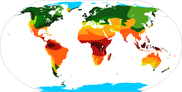
English: Map of precipitation regimes in the world Italiano: Mappa dei regimi precipitativi nel mondo
|
||
| Date | (UTC) | ||
| Source |
|
||
| Author |
|

|
This meteorology image could be re-created using vector graphics as an SVG file. This has several advantages; see Commons:Media for cleanup for more information. If an SVG form of this image is available, please upload it and afterwards replace this template with
{{vector version available|new image name}}.
It is recommended to name the SVG file “Precipitations.svg”—then the template Vector version available (or Vva) does not need the new image name parameter. |
Licensing edit
I, the copyright holder of this work, hereby publish it under the following license:
| I, the copyright holder of this work, release this work into the public domain. This applies worldwide. In some countries this may not be legally possible; if so: I grant anyone the right to use this work for any purpose, without any conditions, unless such conditions are required by law. |
Original upload log edit
This image is a derivative work of the following images:
- File:BlankMap-World-large-noborders.png licensed with PD-self
- 2009-01-19T01:35:51Z The Red Hat of Pat Ferrick 2753x1400 (82103 Bytes) + Antarctica
- 2009-01-03T18:33:32Z The Red Hat of Pat Ferrick 2753x1400 (64001 Bytes) {{Information |Description=Derived from svg map [[:en:Image:BlankMap-World3.svg]] |Source=*[[:File:BlankMap-World-large.png|]] |Date=2009-01-03 18:33 (UTC) |Author=*derivative work: ~~~ *[[:File:BlankMap-World-large.png|]]: R
Uploaded with derivativeFX
File history
Click on a date/time to view the file as it appeared at that time.
| Date/Time | Thumbnail | Dimensions | User | Comment | |
|---|---|---|---|---|---|
| current | 22:56, 6 January 2011 | | 2,753 × 1,400 (101 KB) | Carnby (talk | contribs) | {{Information |Description=Derived from svg map en:Image:BlankMap-World3.svg{{en|Map of precipitation regimes in the world}{{it|mappa dei regimi precipitativi nel mondo}} |Source=Pinna, M. ''L'atmosfera e il clima'', Torino , UTET, 1978, p. 159 |Date |
You cannot overwrite this file.
File usage on Commons
There are no pages that use this file.
File usage on other wikis
The following other wikis use this file:
- Usage on it.wikipedia.org