File:Rif Dimashq offensive (March 2013).svg

Size of this PNG preview of this SVG file: 800 × 523 pixels. Other resolutions: 320 × 209 pixels | 640 × 419 pixels | 1,024 × 670 pixels | 1,280 × 837 pixels | 2,560 × 1,674 pixels | 1,856 × 1,214 pixels.
Original file (SVG file, nominally 1,856 × 1,214 pixels, file size: 13.07 MB)
Captions
Captions
Add a one-line explanation of what this file represents
Summary edit
.svg&action=edit§ion=1)
| Description |
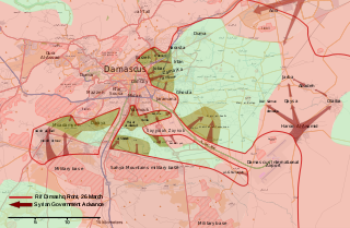
English: Map of the March 2013 Rif Dimashq offensive, showing frontlines before the offensive, and the current strategic situation.
العربية: خريطة تظهر هجوم مارس 2013 على دمشق، تظهر الخريطة خطوط الجبهات قبل الهجوم، و الوضع الاستراتيجي منذ سبتمبر 2013. |
| Date | |
| Source | Own work, OpenStreetMap |
| Author | MrPenguin20 |
Licensing edit
.svg&action=edit§ion=2)
| This work contains information from OpenStreetMap, which is made available under the Open Database License (ODbL).
The ODbL does not require any particular license for maps produced from ODbL data. Prior to 1 August 2020, map tiles produced by the OpenStreetMap Foundation were licensed under the CC-BY-SA-2.0 license. Maps produced by other people may be subject to other licences. |
I, the copyright holder of this work, hereby publish it under the following license:
This file is licensed under the Creative Commons Attribution-Share Alike 3.0 Unported license.
- You are free:
- to share – to copy, distribute and transmit the work
- to remix – to adapt the work
- Under the following conditions:
- attribution – You must give appropriate credit, provide a link to the license, and indicate if changes were made. You may do so in any reasonable manner, but not in any way that suggests the licensor endorses you or your use.
- share alike – If you remix, transform, or build upon the material, you must distribute your contributions under the same or compatible license as the original.
File history
Click on a date/time to view the file as it appeared at that time.
.svg&dir=prev)
.svg&offset=20130903001601)
.svg&offset=&limit=20)
.svg&offset=&limit=50)
.svg&offset=&limit=100)
.svg&offset=&limit=250)
.svg&offset=&limit=500)
| Date/Time | Thumbnail | Dimensions | User | Comment | |
|---|---|---|---|---|---|
| current | 17:27, 6 August 2018 | | 1,856 × 1,214 (13.07 MB) | Rr016 (talk | contribs) | Filled in empty spaces, as per AlAboud83's request |
| 16:55, 7 December 2013 |  | 1,856 × 1,214 (13.06 MB) | EkoGraf (talk | contribs) | This map is for the offensive that lasted until late August. A map for the development of the offensive that started in September already exists | |
| 19:04, 13 November 2013 |  | 1,485 × 971 (11.56 MB) | U5K0 (talk | contribs) | hejeira to loyalists per enwp | |
| 21:57, 7 November 2013 |  | 1,485 × 971 (11.56 MB) | U5K0 (talk | contribs) | Al-Sabinah to loyalists per enwp article | |
| 09:57, 26 October 2013 |  | 1,485 × 971 (11.56 MB) | U5K0 (talk | contribs) | Hatetat al-Turkman per english wp article | |
| 17:37, 9 October 2013 |  | 1,485 × 971 (10.4 MB) | Ahmadac~commonswiki (talk | contribs) | Updated map based on https://en.wikipedia.org/wiki/Template:Syrian_civil_war_detailed_map - Also added Husseiniyah under SAA control. http://www.al-akhbar.com/node/192916 | |
| 00:12, 23 September 2013 |  | 1,856 × 1,214 (13.06 MB) | MrPenguin20 (talk | contribs) | Uploaded correct version. | |
| 00:06, 23 September 2013 |  | 1,856 × 1,214 (13.06 MB) | MrPenguin20 (talk | contribs) | Marked several military bases. Marked Sheba'a. Daraya contested. | |
| 13:34, 15 September 2013 |  | 1,856 × 1,214 (9.33 MB) | MrPenguin20 (talk | contribs) | The M5 highway under the control of SAA before the attack. M1 also under government control. Al-Sabinah, Hujayrah, Deir Salman, Yalda, Babbila and Beit sahem are contested. Hatitat al-Turkuman and Deir al-Asafir under attack from SAA. Qadam also cont... | |
| 00:16, 3 September 2013 |  | 1,856 × 1,214 (9.36 MB) | MrPenguin20 (talk | contribs) | Jamraya & surrounding area under government control according to [https://www.facebook.com/photo.php?fbid=575156802521211&set=a.224155897621305.50803.217139528322942&type=1 new map]. |
You cannot overwrite this file.
File usage on Commons
The following 2 pages use this file:
File usage on other wikis
The following other wikis use this file:
- Usage on ar.wikipedia.org
- Usage on bg.wikipedia.org
- Usage on en.wikipedia.org
- Usage on es.wikipedia.org
- Usage on fr.wikipedia.org
- Usage on he.wikipedia.org
- Usage on it.wikipedia.org
- Usage on pl.wikipedia.org
- Usage on ru.wikipedia.org
- Usage on tr.wikipedia.org
- Usage on www.wikidata.org
- Usage on zh.wikipedia.org
.svg&oldid=502638854)