MrPenguin20
Need help edit
Please make a map of damascus showing territorial inside the capital.
- Sure I'll give it a look :) MrPenguin20 (talk) 12:40, 21 August 2013 (UTC)
Also,the ghab area is under Opposition control.
Shaba’a area is under SAA control
Someone told me the S Vietnam I-IV corps was misspelling? please check
File:Rif Dimashq offensive (March 2013).svg edit
Thank you for File:Rif Dimashq offensive (March 2013).svg. What day does the map nominally reflect? I see you have been making daily changes to the map. Are these intended to reflect daily changes in the battle lines?
I am mostly interested in a map that would reflect the situation as of August 21, 2013. Which one of the multiple versions would best reflect the situation on the night between August 20 and August 21? -- Petri Krohn (talk) 13:31, 28 August 2013 (UTC)
A barnstar for you! edit

|
The Original Barnstar |
| Fantastic work on the symbols and Syrian armed forces flags, I was just creating them myself. Thank you! Jakednb (talk) 14:44, 1 September 2013 (UTC) |
- Is there a chance you can create the badge in two versions; with a black background for "republican guard" and also with a red background for the "defense company". Jakednb (talk) 10:19, 15 September 2013 (UTC)
- Yeah sure! MrPenguin20 (talk) 13:18, 15 September 2013 (UTC)
- Btw, out of interest, which Osprey book did the Defense Company badge appear in? MrPenguin20 (talk) 13:26, 15 September 2013 (UTC)
- Men at Arms #194; Armies of the Middle Eastern wars (2) - plate E. It shows a Defense Companies soldier with the patch in red on his upper left sleeve, and a similar badge over his right jacket pocket. Jakednb (talk) 13:51, 15 September 2013 (UTC)
- Thanks. I've uploaded them now - here and here. Thoughts? MrPenguin20 (talk) 14:48, 15 September 2013 (UTC)
- Men at Arms #194; Armies of the Middle Eastern wars (2) - plate E. It shows a Defense Companies soldier with the patch in red on his upper left sleeve, and a similar badge over his right jacket pocket. Jakednb (talk) 13:51, 15 September 2013 (UTC)
- Btw, out of interest, which Osprey book did the Defense Company badge appear in? MrPenguin20 (talk) 13:26, 15 September 2013 (UTC)
- Yeah sure! MrPenguin20 (talk) 13:18, 15 September 2013 (UTC)
Fantastic! However, I would only say the golden hilts on the black patch look wrong, unless you've seen it somewhere, I would say they are probably also white. In the red version, the skull outline seems a bit thick don't you think? looks really great though, maybe one day you can teach me to work with SVG. Jakednb (talk) 17:34, 15 September 2013 (UTC)
- I was thinking the exact same thing about the skull on the red background. The handles were gold originally because they looked gold on the badges seen here, but I've changed it to white now though - certainly on the soldier in the Osprey book the handles are the same colour as the sword/skull, so maybe they should be white. I'd be happy to :), tbh I mostly learned just through fiddling about with Inkscape! MrPenguin20 (talk) 18:27, 15 September 2013 (UTC)
- Looks great now. I have actually come across other patches, but they are very general (engineers, infantry..), so there is not much really to do with them here. What I really want to find are unit patches. Jakednb (talk) 13:41, 16 September 2013 (UTC)
- Absolutely. The patch I'd most like to find is that for the 4th Armoured Division, and I'm quite surprised how hard it is to find it given the prominence of the Division. If you do find any more unit insignia's I'd be more than willing to turn them into SVG's. MrPenguin20 (talk) 18:53, 16 September 2013 (UTC)
Hey, after hours of searching i found glimpses of division symbols, but i will keep you informed when i find something clear that can be created. For now, i found a patch worn on the upper arm of SF soldiers, I've seen it a few times (for example here), I thought it could be nice to create in SVG. If you need other references i could e-mail you some pictures i gathered, or you could search for them in the web. Jakednb (talk) 15:51, 27 September 2013 (UTC)
- That's great! If you've got any more like that you can either leave a link here or email them to me at Lazzeer@Hotmail.com. I'd actually recently found something quite similar - here there seems to be soldiers wearing a similar badge, but their badge says Republican Guard. MrPenguin20 (talk) 16:16, 27 September 2013 (UTC)
Daraa edit
First of all i would like to thank you for the maps(Syrian civil war) that you created. They are very useful for the users who is fallowing the current situation in the country. As you know, we are using some of your maps at https://en.wikipedia.org/wiki/Template:Syrian_civil_war_detailed_map. So i would like to ask you if you could creat a detailed map for Darra. Since the city is heavy contested we need a map which can show the situation in there. Once again, thanks for your hard work. AOnline (talk) 12:00, 9 October 2013 (UTC)
Jafra,deir ez zor edit
I think it is under opposition control,
- Yeah I think you might be right. Yalla Souriya is certainly reporting it, but I can't seem to find news on it anywhere else (couldnt see a report on it on the SOHR page for example). I think maybe we should wait a couple of days to see if it's reported anywhere else? Or at least until the Wikipedia article is reporting it as under opposition control. MrPenguin20 (talk) 18:35, 19 October 2013 (UTC)
Aleppo map edit
This map has extreme mistakes,abu thuhur airport is besieged,secondly the government control road is completely surrounded with rebel territory,so all white spaces,must be green,Alhanuty (talk) 23:59, 18 October 2013 (UTC)
- Thanks! Yeah Lothar von Richthofen over at wikipedia also pointed out quite a few problems with the map, and as such I've updated the map a bit. The only part of the map that's still white is the area around Khanasser, as I wasn't sure if the SAA control was limited to the road or what. What do you think of the updated map? MrPenguin20 (talk) 18:20, 19 October 2013 (UTC)
Rif dimashq map August -October 2012 edit
There is massive mistakes in that one,which I will point out. http://2.bp.blogspot.com/-65zQiE5K4VI/UAirpDjbm8I/AAAAAAAABaI/A07mquU0s6c/s400/damascustwitter.jpg
The areas with yellow pins where at that time contested,so with brown,darayya was taken by the gov.forces on August 26 2012,mezzah wasn't contested,at all ,and mouadamiya was the only one that stayed under rebel control,but you can mark that one as contested,jadedat alfadel was under government control,and try to mark khan al sheh on the map,and Harran alawamid was government controlled also nashabiyah and Marjal sultan and Meliha and shabba was under government control and the area east probably under government control except a road leading to otaiba,and the most important Assad was controlling douma till mid October.i will give you other corrections soon.Alhanuty (talk) 23:58, 19 October 2013 (UTC)
- Cool thanks I'll get working on updating it. About Mezzeh - the Rif Dimashq offensive (August–October 2012) page refers to clashes there, and also the map that you linked to shows the area as contested. (the residential district, not the airport) MrPenguin20 (talk) 12:25, 28 October 2013 (UTC)
Small corrections in flags edit
Dear friend: many thanks for your fabulous work. As expert vexillologist I found two small mistakes in flags you create, that i believe that you prefer correct them for to have you wonderful job fully perfect: the armed forces of Syria have gilded inscriptions in the red and the black stripes, and both are curved as semi-circle. The Bahrain army lack a half moon below the shield. I assume that you can find the references easely in the web, but if is need please write me to my e-mail jolle@terra.com I have serious problems for draw images with arabic inscriptions while you maitrise this job. Sorry for my bad english, and receive my great admiration; Jolle.
Request edit
A request for an expert on arab symbols: Can you
- Redraw File:Coat of arms of North Yemen (1962–1990).png according to File:Emblem of Yemen.svg
- Improve de:Datei:Flag of Hezbollah.svg?
--Antemister (talk) 22:56, 2 November 2013 (UTC)
No problem! COA is uploaded now - seen here. Not sure what you want me to do to the Hezbollah flag - the version you linked to looks pretty much perfect in my opinion! MrPenguin20 (talk) 02:47, 4 November 2013 (UTC)
- One more SVG of a national emblem. For the Hezbollah's flag, most parts are perfectly done, but the globe and the leaves are only autotraced.--Antemister (talk) 21:32, 5 November 2013 (UTC)
- Yeah I see what you mean. I'll get working on it. MrPenguin20 (talk) 00:42, 6 November 2013 (UTC)
- Ok, that looks better than before. Unfortunately, it will not tbe possible to keep that file on Commons, it was deleted more than one time yet, as it is a copyright image above threshold of originality. One has to upload it to each WP as Fair-Use image. Another issue, you might be interested. Some days ago, I obtained a quite rare book: A reprint of an official book of flags and symbols of the south vietnamese armed forces. It contains images you'll not find elsewhere, as most stuff was publically burned after 1975. I scanned that book, and as I saw that you also draw some symbols of south vietnamese army units, you might be interested in it.--Antemister (talk) 22:05, 14 November 2013 (UTC)
- Absolutely! Just send me the scans and I'll get working on them! You can email me at Lazzeer@Hotmail.com. MrPenguin20 (talk) 01:21, 15 November 2013 (UTC)
- Sent you an eMail. Another note: For some months, Category:Military symbols of South Vietnam contains several files, uploaded by blocked User:Namkhanh02 and his sockpuppets. He seems to have access to an vietnamese publication on that topic or he used the some publication. But these files are no real SVGs, the reason why he was blocked repeatedly.--Antemister (talk) 22:09, 15 November 2013 (UTC)
- Absolutely! Just send me the scans and I'll get working on them! You can email me at Lazzeer@Hotmail.com. MrPenguin20 (talk) 01:21, 15 November 2013 (UTC)
- Yeah I noticed that a while ago. I'll get working on turning them into real SVG's. MrPenguin20 (talk) 22:47, 15 November 2013 (UTC)
Map of Rif Damashq edit
Dear MrPenguin20
First of all i want to say that your maps are great! But in the "Rif Damashq offensive Map (since September)" there is a place which is (was always) controlled by Assad regime troops. This region south of the airport road, between "Al-Husseiniya" and "al-Ghizlanieh" with the "Ebla Cham hotel" and the "Damascus Fairground" are controlled by Assad.
Your sincerely Bernd
- Oh dear I think you're right. Look's like there's quite a bit of fixing for me to do! Thanks for pointing this out! MrPenguin20 (talk) 00:56, 14 November 2013 (UTC)
A previous version of this file was deleted as a copyright violation, and this one could go the same way... AnonMoos (talk) 07:06, 16 November 2013 (UTC)
Wrong image text on user page edit
The Image text on the Image
Image:Damascus offensive (November 2012).svg|Map of the November 2013 Damascus Offensive.
ought to be
Image:Damascus offensive (November 2012).svg|Map of the November 2012 Damascus Offensive.
- Oops! Thanks - fixed now. MrPenguin20 (talk) 23:38, 16 November 2013 (UTC)
5th Rif Dimashq offensive map edit
Hello, I think the situation has changed since the last time you edited the map so I think maybe you could show the rebel advance in the eastern Ghouta and the siege broken or at least weakened. Thanks --Amedjay (talk) 13:31, 30 November 2013 (UTC)
How do you edit this map,so I could update it also.Alhanuty (talk) 03:06, 5 December 2013 (UTC)
- Yeah that'd be good thanks (I'm pretty swamped with work atm). Personally I use Inkscape (which is also free). MrPenguin20 (talk) 12:23, 5 December 2013 (UTC)
How do you change colors and shapes,please,I am lost on this.24.0.210.152 04:02, 10 January 2014 (UTC)
But how exactly do you edit it.24.0.210.152 04:30, 6 December 2013 (UTC)
Category:Someone told me the S Vietnam I-IV corps was misspelling? please check Category:Thanks
Someone told me the S Vietnam I-IV corps was misspelling? please check
- Thanks. Any idea what the problem is? MrPenguin20 (talk) 21:04, 10 December 2013 (UTC)
- In reef dimashq i think the syrian army now is controlling barazeh and al mouadamieh! or at least no more rebels there but syrian gov. police! i think it should be red now
thanks
- Neither the government or the opposition fully controls either, but they seem to be operating some kind of shaky truce. I think the current Barzeh arrangement looks about right, especially if the truce line is outside Al-Salam mosque. I think it's a good point you've made about Maadamiyeh, especially if you're right about there being a police presence. There's still some kind of opposition presence marked here, although I suppose that might be out of date. Since there's a bit of uncertainty for now I've reduced and consolidated the opposition control a bit, and then marked it with a truce line. If it emerges later though that government control is quite strong then I'll change it to government controlled though. Thanks! MrPenguin20 (talk) 21:28, 4 February 2014 (UTC)
The new changes are correct! Mouadamieh isn't in army control! according to thr truce, army soldiers are not allowed to enter to the city but only make checkpoints at its entrance! On the other side rebels should give up their arms too and police will take over the situation there there! Therefor i dont know if you should color it in red or green! I suggest also you do a map for al qalamoun since it is a really important frontline and a new map for aleppo that look like those of dier ezzor or homs because the one currently existing is not representive of the current situation! Which programe do you use to do maps ? Thank you and i really hope you do something about qalamoun frontline!
- Hello, there is a truce in Babbila, Yalda and Beit Sohom now! :)
- Thanks! Updated now. MrPenguin20 (talk) 14:36, 19 February 2014 (UTC)
Hello MrPenguin20! Can you make a map for the qalamoun frontline as well as for aleppo ? (The current one is really ugly and outdated). Everyone will be very thankfull!
- I've got a Qalamoun map in the works, shouldn't take too long now. I dunno if I'll do an Aleppo one soon though - don't want to step on anyones toes! (Might do though!) MrPenguin20 (talk) 02:56, 24 February 2014 (UTC)
That flag did never exist! I checked the book several times now, and did not find it there. You drew it according to File:Flag of the South Vietnamese Army.jpg, of course, but it seems that this flag is completely wrong. The book contains File:Flag of ARVN.svg as the flag of the south vietnamese military forces (not the one of the army = ground forces, it has a red background and a different motto, p50), and then a flag with an red eagle on page 64 as the flag of the president as supreme commander of the armed forces. But there are no red stripes and no wreath behind the eagle. The eagle with the wreath behind shows is in fact the hat badge (p48).--Antemister (talk) 22:47, 19 December 2013 (UTC)
- Yeah I noticed that too. The only place a similarish depiction exists is on the cover, and also in the link you sent. Maybe it's some kind of unofficial flag? MrPenguin20 (talk) 00:05, 20 December 2013 (UTC)
- That's the problem with it: An unofficial military flag? That may be logical, if it would be a civilian one (like that or that that, which can be seen very often here in Bavaria, although unofficial). I assume that the book cover is a rather silly artwork by the editor, who combined the eagle of the military flag, the stripes of the national one with the emblem the armed forces. But that does of course not explain the quite different one here on Commons. File:Flag of the President of the Republic of Vietnam.svg is not really the "Flag of the President of the Republic of Vietnam", but rather "Flag of the President of the Republic of Vietnam as supreme Commander of the armed Forces". The flag(s) of the president of vietnam can be found here.--Antemister (talk) 22:59, 20 December 2013 (UTC)
- Very true. I've seen other versions of it too - e.g. here. It was exactly because of the big variations between depictions of the flag that I thought it might be some kind of unofficial flag. I suppose alternatively it could be legitimate and was simply been adopted post 1971, but I don't think I've seen any photos of any actual real life flag versions. For the Presidential flag I've now changed the flags' description and requested it be moved to your suggested name. Also I've designed a new face for the bird which I think is closer to most of the depictions than the one I was previously using. I've just updated the National Defense Minister flag so far. Thoughts? MrPenguin20 (talk) 01:27, 21 December 2013 (UTC)
- The introduction of a new flag after 1971 seems to be unfeasible. I assume that this variant is an incorrect depiction drawn by some exile groups in the US ("the eagle of the military forces on a yellow flag" - you can draw both versions if you have just that description of it). It can be found on many websites of those south vietnam nostalgia groups, copied from each other. My suggestion/commons procedure on issues like that is simple: Starting a DR. Doubtful flags cannot be used in articles, and their existence on Commons provide some legitimicy to them. Other websites copy them, and so they are more and more spread throughout the web. Verifying their correctness becomes even more difficult.--Antemister (talk) 12:57, 21 December 2013 (UTC)
- Yeah it's a fair point. I'm not too informed on the process whereby items are deleted from wikicommons, but if you want to request the files deletion then I won't oppose it, given the seeming lack of any historic (or contemporary) backing for its use. MrPenguin20 (talk) 22:23, 22 December 2013 (UTC)
- OK, will do that - after you have uploaded the hat badge as a separate fle.--Antemister (talk) 12:21, 24 December 2013 (UTC)
- KK have uploaded them now. MrPenguin20 (talk) 16:09, 24 December 2013 (UTC)
- OK, will do that - after you have uploaded the hat badge as a separate fle.--Antemister (talk) 12:21, 24 December 2013 (UTC)
- Yeah it's a fair point. I'm not too informed on the process whereby items are deleted from wikicommons, but if you want to request the files deletion then I won't oppose it, given the seeming lack of any historic (or contemporary) backing for its use. MrPenguin20 (talk) 22:23, 22 December 2013 (UTC)
- The introduction of a new flag after 1971 seems to be unfeasible. I assume that this variant is an incorrect depiction drawn by some exile groups in the US ("the eagle of the military forces on a yellow flag" - you can draw both versions if you have just that description of it). It can be found on many websites of those south vietnam nostalgia groups, copied from each other. My suggestion/commons procedure on issues like that is simple: Starting a DR. Doubtful flags cannot be used in articles, and their existence on Commons provide some legitimicy to them. Other websites copy them, and so they are more and more spread throughout the web. Verifying their correctness becomes even more difficult.--Antemister (talk) 12:57, 21 December 2013 (UTC)
- Very true. I've seen other versions of it too - e.g. here. It was exactly because of the big variations between depictions of the flag that I thought it might be some kind of unofficial flag. I suppose alternatively it could be legitimate and was simply been adopted post 1971, but I don't think I've seen any photos of any actual real life flag versions. For the Presidential flag I've now changed the flags' description and requested it be moved to your suggested name. Also I've designed a new face for the bird which I think is closer to most of the depictions than the one I was previously using. I've just updated the National Defense Minister flag so far. Thoughts? MrPenguin20 (talk) 01:27, 21 December 2013 (UTC)
- That's the problem with it: An unofficial military flag? That may be logical, if it would be a civilian one (like that or that that, which can be seen very often here in Bavaria, although unofficial). I assume that the book cover is a rather silly artwork by the editor, who combined the eagle of the military flag, the stripes of the national one with the emblem the armed forces. But that does of course not explain the quite different one here on Commons. File:Flag of the President of the Republic of Vietnam.svg is not really the "Flag of the President of the Republic of Vietnam", but rather "Flag of the President of the Republic of Vietnam as supreme Commander of the armed Forces". The flag(s) of the president of vietnam can be found here.--Antemister (talk) 22:59, 20 December 2013 (UTC)
BTW, the afghan MOI insignia in color: [1]--Antemister (talk) 22:47, 19 December 2013 (UTC)
- Thanks! Updated now :) MrPenguin20 (talk) 00:05, 20 December 2013 (UTC)
- Also the Airforce has such an emblem: [2]--Antemister (talk) 22:59, 20 December 2013 (UTC)
- Good find. I'll add that to the to-do list. MrPenguin20 (talk) 01:27, 21 December 2013 (UTC)
- Also the Airforce has such an emblem: [2]--Antemister (talk) 22:59, 20 December 2013 (UTC)
Need help edit
Can you make the flags of Bahrain's National Guard? [3]--Zxs1 (talk) 07:17, 29 December 2013 (UTC)
- Sure I'll get working on that now. MrPenguin20 (talk) 13:20, 29 December 2013 (UTC)
- Uploaded now. MrPenguin20 (talk) 14:17, 29 December 2013 (UTC)
Thank you very much--Zxs1 (talk) 22:01, 29 December 2013 (UTC)
The last one Royal Medical Services And BDF finished [4]--Zxs1 (talk) 04:10, 31 December 2013 (UTC)
- Do you know if there is a flag as well or is there just a logo? MrPenguin20 (talk) 13:20, 31 December 2013 (UTC)
yes flag [5]--Zxs1 (talk) 14:29, 31 December 2013 (UTC)
Hello. Would you please tell me what program you used to make this image in SVG? And how could you make it so clean while the source image is so bad? I would be so glad if you answered me. Regards.--Avocato (talk) 06:31, 31 December 2013 (UTC)
- Sure! I personally use Inkscape - which is a free program. It might seem a bit tricky to initially get used to, as it's pretty different from photoshop etc, but there's quite a few good guides/tutorials available online. MrPenguin20 (talk) 13:20, 31 December 2013 (UTC)
- Thanks for replying, I really appreciate that. I ask you, please, to explain some points about Inkscape:
- After opening any file, what should I choose: Link image, or embed image?
- What tools you used in order to make the image so clean and better than the original one?
- In what type should I save the image: "Inkscape SVG", "Plain SVG", "Compressed Inkscape SVG", or "Compressed Plain SVG"?
- Thanks again and sorry for any nuisance I may caused.--Avocato (talk) 17:07, 3 January 2014 (UTC)
- Thanks for replying, I really appreciate that. I ask you, please, to explain some points about Inkscape:
- It's no nuisance at all - always happy to help!
- 1. I assume that you're dragging and dropping a non svg file into inkscape? In that case you select embed.
- 2. Once the file is embedded then you have to trace it. This can be done automatically within Inkscape, or alternatively there's other applications which can turn images into svg's, although they often aren't that precise. I personally tend to trace the files in Inkscape manually, like the person in this video, by drawing over them using the drawing tools in Inkscape, as this results in more accurate/higher definition end results. When I first started using Inkscape though what I'd do is that I'd use vector magic, and then touch up the file within Inkscape.
- 3. I personally just save it as an Inkscape SVG. MrPenguin20 (talk) 20:16, 3 January 2014 (UTC)
- It's no nuisance at all - always happy to help!
- Hello. Check this out and tell me about your opinion. :)--Avocato (talk) 04:23, 13 January 2014 (UTC)
- Great job! Believe me, it's far far far superior to my first stuff when I started using Inkscape. MrPenguin20 (talk) 00:30, 15 January 2014 (UTC)
- I am very grateful for your encouraging words.--Avocato (talk) 22:04, 17 January 2014 (UTC)
- No problem! I look forward to see what you'll produce next :) MrPenguin20 (talk) 23:30, 17 January 2014 (UTC)
- I am very grateful for your encouraging words.--Avocato (talk) 22:04, 17 January 2014 (UTC)
- Great job! Believe me, it's far far far superior to my first stuff when I started using Inkscape. MrPenguin20 (talk) 00:30, 15 January 2014 (UTC)
- Hello. Check this out and tell me about your opinion. :)--Avocato (talk) 04:23, 13 January 2014 (UTC)
Can be found in Category:Sockpuppets of Namkhanh02--Antemister (talk) 11:46, 2 January 2014 (UTC)
Libya edit
Do not know if you are interested in that and if a vectorisation does make sense, as sooner or later the image can be found an official PDF, but I do not want to loose that research: An official en:Coat of arms of Libya does not exist now, but having a look on several website of state authorities [6][7], [8], [9], [10], [11] one can see that most of them use en:File:Libya PM logo.png. (exceptions [12], [13], [14], [15]). Question: Does the standard emblem have an own text for each ministry?--Antemister (talk) 15:14, 5 January 2014 (UTC)
- Yeah they're each individualized; they all say Libyan Interim Government (الحكومة الليبية المؤقتة) at the top, and then each one is individualized for the bottom text. So they say Ministry of Industry (وزارة الصناعة), Ministry of Defence (وزارة الدفاع), Ministry of Foreign Affairs (وزارة الخارجية والتعاون الدولي) etc. Bit busy atm, but I'll work on svg versions later. Of course these might all change after the new constitution is written, but I'm guessing that won't be for a while. MrPenguin20 (talk) 18:10, 7 January 2014 (UTC)
This file had some kind of complex gradient in the Iraq outline, which I didn't understand; I substituted File:Flag-map_of_Iraq.svg instead... AnonMoos (talk) 08:59, 8 January 2014 (UTC)
A barnstar for you! edit

|
The Graphic Designer's Barnstar |
| what a great work man. thanks for the maps about the syrian situation and the control conflicts in each city, you are 95% accurate I wait your updates every day. Some maps are now very old and I wonder when you will update them :). Barcaxx1980 (talk) 17:39, 10 January 2014 (UTC) |
- Many thanks! I know what you mean about some of them now being a bit out of date though... Which one do you think I should work on updating first? MrPenguin20 (talk) 20:35, 12 January 2014 (UTC)
New Syrian civil war flags and emblems edit
Hi, first congratulations for your incredible work on the Syrian civil war maps, flags, emblems, etc... You have done an impressive graphic job, sincerely. Then, I would like to ask you for some more work:
- I've seen that you have done the Islamic Front flag, but it seems that a different colours version is more widely used by that militia, as shown here, here & here.
- Also, I would ask you to make the Palestine Liberation Army emblem (wich could be seen here). It seems that the emblem is very similar to the Syrian coat of arms, with the differences of the colours, the Palestinian flag instead of the Syrian flag in the Escutcheon, and a different motto in Arabic.
Thank you again for your work and regards, --HCPUNXKID (talk) 22:41, 14 January 2014 (UTC)
- Thanks for the kind words, and also thanks for the heads up about the flag! I've uploaded an updated version now. Also the emblem of the PLA is now uploaded too. If ever notice any other problems with anything I've uploaded, or if you have any other requests, just let me know :). MrPenguin20 (talk) 00:28, 15 January 2014 (UTC)
Al-Nusra Front flag edit
Hi, congratulations for your work on syrian flags, it was amazing flag. There is new flag of Al-Nusra Front I have uploaded. i think it will be so nice service if you edit the SVG version . :)

- Thanks! And thanks a lot for adding to the description - it's really appreciated! I shall get to work on the new flag :) MrPenguin20 (talk) 23:07, 19 January 2014 (UTC)
Siege of Homs map edit
The rebels control the entire north country side of Homs,check the template map for further details,and PLEASE,PLEASE,edit the rif dimashq offensive map showing the rebel counter offensive,where they capture qasimiyah,al jarba,bahariya,and including adra as contested,also the rebels did capture deir salman ,but they where driven out of it,and most IMPORTANT,that abadah is contested,and increase the territory that rebels control east of otaybah,and please mew need these edits soon,becuz the map is very so outdated.Alhanuty (talk) 02:51, 30 January 2014 (UTC)
- Oh dear that does sound quite bad! I shall fix all of those tomorrow! MrPenguin20 (talk) 03:14, 30 January 2014 (UTC)
- I've added the opposition offensive in the east to the map, although I've not changed Adra to contested because the map shows the course of the Rif Dimashq offensive from September to November, and it looks like the offensive into Adra took place in December. I've also changed the borders around Babilla and Beit Sahm - according to the detailed map it looks like there's still some kind of opposition presence. The area described as Yarmouk has been increased (in line with reality), and so the new area has also been marked as contested. Tadamon is also now on the map, and is marked as contested.
- In southern Ghouta I've changed the status of Sakka and Dulba to government-held, in line with the detailed map (this might not be a recent change, but might instead just have been something that's been wrongly marked on the map for a while).
- I've made some changes to Otaybah, but do you know where about the villages taken by the opposition are? Like are they east, south, north, etc?
- Then for Homs I expanded the area controlled by the opposition to the north of the city, although it already largely follows the areas shown as opposition controlled according to the detailed map. If the map went slightly farther north then you'd see opposition control branch out a lot more due to Talbiseh, Zafaranah etc, but for the area shown the level of control seems about right. MrPenguin20 (talk) 19:08, 30 January 2014 (UTC)
Thanks for these changes but I think you forgot something important in the rif Dimashq map: Adra. It has been reported that rebels have taken over the area north east of Duma and North of Brigade 39 which is besieged. Also there's a truce in Barzeh and Qaboun so maybe we should find a way to represent that. Thanks. --Amedjay (talk) 15:48, 1 February 2014 (UTC)
- Yeah I'd intentionally left the Adra offensive out since the map was supposed to be for the article relating to the fighting between September & November whereas the Adra fighting took place in December. Having said that there seems to be no other article for the current fighting, so I guess I'll just edit the map to show the current situation. And yeah that's a good point about Barzeh and Qaboun! MrPenguin20 (talk) 23:12, 1 February 2014 (UTC)
- Ok the Adra offensive is now shown, and I've marked the truce area too. I think there might still be some issues with the way the Adra offensive is shown (opposition might control more ground to the north), but as a whole it's getting there. MrPenguin20 (talk) 03:50, 2 February 2014 (UTC)
Thanks, the changes look good. However I forgot to mention that there's also a truce in Maadamiyeh and that we should probably extand rebel control in Darayya a bit northwards and add Qadam as rebel controlled as they were able to make regime cut the road that lies from Damascus to Daraa. Still they were repelled but that's a proof that rebels are still ative in Darayya --Amedjay (talk) 19:50, 3 February 2014 (UTC)
- Thanks! I've updated it a bit more now. MrPenguin20 (talk) 21:20, 4 February 2014 (UTC)
Thanks for the Homs map. It was long overdue. However, the central rebel pocket is not up to date. If you could draw it to mimic the map in Wall Street Journal article from Jan. 27, 2014, it would be great. While you're at it, you might want to remove the label "Homs" from the middle of the map as it is obvious from the caption. Tradediatalk 20:31, 3 February 2014 (UTC)
- Thanks! Updated now. MrPenguin20 (talk) 21:20, 4 February 2014 (UTC)
Using File:Arms of the Islamic Emirate of Afghanistan.svg, you can improve that image.--Antemister (talk) 20:53, 21 February 2014 (UTC)
- Thanks! Yeah I'm working on a better definition version of the logo. Should be done soonish. MrPenguin20 (talk) 02:53, 24 February 2014 (UTC)
File: Battle of Daraa City.svg edit
Dear MrPenguin20,
It's a pleasure to talk to you. I have read in 2014 Daraa offensive that the Ghaz Prison and some silos have been taken by the Syrian rebels, which means that the connection between Daraa and Umm al Mayadin should be removed.
Since this map is used in the template:Syrian Civil War detailed map you may like to change it.
Sorry for the inconvenience
Best regards --83.42.97.135 22:53, 22 March 2014 (UTC)
- Hi there! Thanks for the information - currently updating the map now. :) MrPenguin20 (talk) 21:56, 29 March 2014 (UTC)
The File:Battle of Daraa City.svg contains raster elements edit
Quality issue 
|
The SVG image File:Battle of Daraa City.svg you uploaded contains embedded raster graphics and is now listed in Category:SVG images with embedded raster graphics. Such images are liable to produce inferior results when scaled to different sizes. If appropriate, please replace the raster graphics with vector graphics. You can either upload an improved version or simply allow the file to be deleted.
In all cases, please do not take this message personally. It is never intended as such. Thank you! --Cwbm (commons) (talk) 09:20, 30 March 2014 (UTC) |
The File:Battle of Qalamoun.svg contains raster elements edit
| Quality issue
|
The SVG image File:Battle of Qalamoun.svg you uploaded contains embedded raster graphics and is now listed in Category:SVG images with embedded raster graphics. Such images are liable to produce inferior results when scaled to different sizes. If appropriate, please replace the raster graphics with vector graphics. You can either upload an improved version or simply allow the file to be deleted.
In all cases, please do not take this message personally. It is never intended as such. Thank you! --Cwbm (commons) (talk) 09:21, 30 March 2014 (UTC) |
The File:2014 Latakia Offensive Map.svg contains raster elements edit
| Quality issue
|
The SVG image File:2014 Latakia Offensive Map.svg you uploaded contains embedded raster graphics and is now listed in Category:SVG images with embedded raster graphics. Such images are liable to produce inferior results when scaled to different sizes. If appropriate, please replace the raster graphics with vector graphics. You can either upload an improved version or simply allow the file to be deleted.
In all cases, please do not take this message personally. It is never intended as such. Thank you! --Cwbm (commons) (talk) 09:24, 30 March 2014 (UTC) |
Notification about possible deletion edit

|
Some contents have been listed at Commons:Deletion requests so that the community can discuss whether they should be kept or not. We would appreciate it if you could go to voice your opinion about this at their entry.
If you created these pages, please note that the fact that they have been proposed for deletion does not necessarily mean that we do not value your kind contribution. It simply means that one person believes that there is some specific problem with them, such as a copyright issue. Please see Commons:But it's my own work! for a guide on how to address these issues. |
Affected:
And also:
- File:Flag of the Donetsk Republic (Organisation).svg
- File:Flag of the Kharkov People's Republic.svg
- File:Flag of the Lugansk Parliamentary Republic.svg
Yours sincerely, Anatoliy (talk) 01:14, 18 May 2014 (UTC)
Non free logos edit
Dear MrPenguin20
Logos of political parties are copyright protected and can not be kept in commons. Soon or late all of them will be deleted. I suggest you to upload them as "non-free content" it English wiki or another wikis, the place that can keep them forever. Monfie (talk) 06:02, 8 June 2014 (UTC)
- Will do! :) MrPenguin20 (talk) 22:20, 8 June 2014 (UTC)
Deir ez-Zor city map edit
The Deir ez-Zor city map needs to be modified. All territory north and east across the river from the city is ISIS-controlled [16][17]. Thank you in advance!
ISIS has captured all opposition-held areas in the provincial capital [18][19], please modify the map. Thanks! EkoGraf
Thank you edit
Thank you for making flags of the Libyan army But Missing flag of the Libyan Navy ,Seal [20] flag [21]--84.255.148.225 07:19, 17 August 2014 (UTC)
- Thanks! Yeah I'm working on it atm - did a couple of other things first because I find doing the rope-circle quite boring. Should be uploaded soon though! MrPenguin20 (talk) 16:28, 17 August 2014 (UTC)
Thank you, if u need any Information about Libyan army I'm here Zxs--84.255.148.225 20:06, 17 August 2014 (UTC)
- Thanks! MrPenguin20 (talk) 00:55, 20 August 2014 (UTC)
Kalmius Battalion edit
Hi again, how are you?. As usual, I came here with a petition. Here you have the shoulder sleeve patch of the Kalmius Battalion, a rebel unit within the Novorossiya side. Could you made the drawing to ilustrate the Donbass People's Militia article and others, please?. Regards,--HCPUNXKID (talk) 13:39, 31 August 2014 (UTC)
- Sure I'll get working on them! MrPenguin20 (talk) 23:14, 1 September 2014 (UTC)
- I've completed and uploaded the Zarya Battalion SSI, but I'm a little stuck on the Kalmius Battalion. What does the text on the left hand side of the SSI say? It looks to me like "СОЦЛО ДРА3ДЕЛЕНИЕ" - does that make any sense in Russian? MrPenguin20 (talk) 15:21, 14 September 2014 (UTC)
- Thank you very much for the Zarya Battalion SSI! Hope you could made the Kalmius one soon!.--HCPUNXKID (talk) 14:37, 15 September 2014 (UTC)
- No problem. The Kalmius one is done too - it's here. MrPenguin20 (talk) 15:41, 15 September 2014 (UTC)
- Again, thank you very much. Your work is brilliant!.--HCPUNXKID (talk) 14:02, 18 September 2014 (UTC)
- Many thanks :P. If you need/want anything else just let me know. MrPenguin20 (talk) 22:57, 18 September 2014 (UTC)
- Again, thank you very much. Your work is brilliant!.--HCPUNXKID (talk) 14:02, 18 September 2014 (UTC)
- No problem. The Kalmius one is done too - it's here. MrPenguin20 (talk) 15:41, 15 September 2014 (UTC)
- Thank you very much for the Zarya Battalion SSI! Hope you could made the Kalmius one soon!.--HCPUNXKID (talk) 14:37, 15 September 2014 (UTC)
КАЛЬМИУС
СПЕЦПОДРАЗДЕЛЕНИЕ | ДНР | МИНИСТЕРСТВО ОБОРОНЫ
Which means smth like: Kalmius|Special Division|DPR|Ministry of Defence
ready to help with russian texts.)
Winand (talk) 04:52, 15 September 2014 (UTC)
- That's fantastic! Many thanks. I may have to call on you again :P MrPenguin20 (talk) 15:40, 15 September 2014 (UTC)
Zarya battalion edit
Same thing happens with the Zarya battalion, here's a screenshot showing the shoulder sleeve insignia.--HCPUNXKID (talk) 22:04, 31 August 2014 (UTC)
Request edit
I've seen your good flags across Wikipedia, and I was wondering if you could do us all a favour and make a good SVG version of this flag. It is the flag of the National Guard of Ukraine, and the present image is both sub-par and useless for infoboxes. Thanks for your assistance! RGloucester (talk) 15:51, 12 September 2014 (UTC)
- Sure no problem! MrPenguin20 (talk)
- Woops looks like someone else got there first. MrPenguin20 (talk) 13:56, 14 September 2014 (UTC)
Battle of Hasakah edit
You can update this map Battle of Hasakah because Syrian army recaptured Ghuweiran neighborhood in city Hasakah.SOHRDocumens.Sy--Hanibal911 (talk) 17:57, 17 September 2014 (UTC)
- Thanks! MrPenguin20 (talk) 22:16, 17 September 2014 (UTC)
- I hope you will soon update the map. Regards!--Hanibal911 (talk) 14:14, 20 September 2014 (UTC)
- Sorry been a bit busy with other stuff. Shall upload the updated versions early tomorrow/today! MrPenguin20 (talk) 01:16, 22 September 2014 (UTC)
- Yeah looks like HCPUNXKID got there first. I double checked and the current version seems to be supported by the links you provided. Thanks MrPenguin20 (talk) 18:18, 22 September 2014 (UTC)
- Sorry been a bit busy with other stuff. Shall upload the updated versions early tomorrow/today! MrPenguin20 (talk) 01:16, 22 September 2014 (UTC)
- I hope you will soon update the map. Regards!--Hanibal911 (talk) 14:14, 20 September 2014 (UTC)
Should the Hasakah city map be changed based on this [22]. The current one is outdated.
Legion of Saint Stephen edit
So there's another SSI petition. This time is the Legion of Saint Stephen, a Hungarian volunteer group in the Donbass war. Here's their FB official page emblem picture: https://www.facebook.com/752238441485296/photos/a.752244034818070.1073741827.752238441485296/752244008151406/?type=1&theater. Regards, --HCPUNXKID (talk) 13:28, 18 September 2014 (UTC)
- Done!. MrPenguin20 (talk) 17:10, 18 September 2014 (UTC)
- Nice and so quick!.--HCPUNXKID (talk) 23:19, 18 September 2014 (UTC)
Forças Populares 25 de Abril edit
Hi!, Here I am with another petition: The flag of the 25 April Popular Forces, a Portuguese armed group in the 80's. Here you have images of their flag. Regards,--HCPUNXKID (talk) 17:54, 25 September 2014 (UTC)
- No problemo. Logo and flag should be finished/uploaded tomorrow! MrPenguin20 (talk) 01:04, 26 September 2014 (UTC)
- Logo is here and flag is here. They look slightly different to the version in the link you gave, but I think they're legit - I based them on the flag and logo seen in this video. MrPenguin20 (talk) 22:11, 26 September 2014 (UTC)
- Better version gone up now - I had missed out the hand clutching the rifle. I also redid the rifle a bit, so now it's exactly as it appears in the FP-25 video. MrPenguin20 (talk) 12:28, 29 September 2014 (UTC)
- Nice correction!--HCPUNXKID (talk) 14:41, 1 October 2014 (UTC)
- Better version gone up now - I had missed out the hand clutching the rifle. I also redid the rifle a bit, so now it's exactly as it appears in the FP-25 video. MrPenguin20 (talk) 12:28, 29 September 2014 (UTC)
- Logo is here and flag is here. They look slightly different to the version in the link you gave, but I think they're legit - I based them on the flag and logo seen in this video. MrPenguin20 (talk) 22:11, 26 September 2014 (UTC)
1979 Herat uprising flag edit
Hi again, this time my petition is simple, adding some arabic words to a green flag, in order to fit in the depiction of that flag and to avoid confusion with others (for example, the former Lybian flag). Here you can see an official depiction of the flag. Regards,--HCPUNXKID (talk) 15:14, 1 October 2014 (UTC)
- Done! Not too sure about the green I've used - will probably change that. MrPenguin20 (talk) 15:39, 1 October 2014 (UTC)
- Nice, as usual.--HCPUNXKID (talk) 21:47, 1 October 2014 (UTC)
Symbols of Tannu Tuva edit
For almost a year, that large request on creating SVGs of tuvan flags can be found on my computer, and it it still not done yet. Could yo do it, if you have time?
For any Flag, please use the red coloras well as the aspect ratio from File:Flag of the Tuvan People's Republic (1941-1943).svg, and an equal size for the emblems in the flags. Make sure that the en:Yañalif letter is not lost.
Create File:Flag of Uriankhai (1921 variant).svg, according to rus_tu9.GIF in my email, using File:Flag of the Tuvinian Peoples Revolutionary Party.svgCreate File:Flag of Uriankhai (1917-1918 variant).svg, according to ru_tuva1917.gif in my email.For File:Flag of Uriankhai (1918-1921).svg, use the same ratio as for File:Flag of the Tuvan People's Republic (1941-1943).svg, and adapt the thickness of the contours of of the khorlo wheel and the white bands according to ru_tuva1914.gif in the emailFile:Flag of the Tuvan People's Republic (1926-1930).svg does already exist, but adapt the red color shade and the ratio to the other files of the series, and use the text from the PDF in my eMail.- Create File:Flag of the Tuvan People's Republic (1930-1933).svg, using File:Emblem of the Tuvan People's Republic (1930-1933).svg, according to File:Flag of Tannu Tuva (1930 to 1933).png
- Use File:Emblem of the Tuvan People's Republic (1933-1939).svg, replace the text by "PYGY TELEGEJNIꞐ PROLETARLARЬ, KATTЬƵЬꞐAR!" according to [23] and upload it as File:Emblem of the Tuvan People's Republic (1939-1941).svg hoch
- Create File:Flag of the Tuvan People's Republic (1939-1941).svg, using File:Emblem of the Tuvan Peoples' Republic (1939-1941).svg, according to File:Tuvan People's Republic flag 1933-1939.png
- Use File:Emblem of the Tuvan People's Republic (1943-1944).svg and replace the text by "БҮГҮ ТЕЛЕГЕЙНИҢ ПРОЛЕТАРЛАРЫ БОЛГАШ ЧӨӨН ЧҮКТҮҢ ДАРЛАТКАН АРАТТАРЫ КАТТЫЖЫҢАР!" according to [24]
- Use File:Emblem of the Tuvan People's Republic (1943-1944).svg replace the text by "PYGY TELEGEJNIꞐ PROLETARLARЬ POLGAŞ CƟƟN CYKTYꞐ TARLATKAN ARATTARЬ KATTЬƵЬꞐAR!" as well as "TAP" by "TAR" (cyrillic letters!), according to [25] and upload it as File:Emblem of the Tuvan Peoples' Republic (1941-1943).svg
- For File:Flag of the Tuvan People's Republic (1941-1943).svg and File:Flag of the Tuvan People's Republic (1943-1944).svg, use equal font and font size, see the William Crampton article
- Create File:Coat of arms of the Tuvan ASSR (1962-1978).svg as well as File:Coat of arms of the Tuvan ASSR (1978-1992).svg using File:Coat of arms of Crimean ASSR.svg and File:Coat of arms of Kalmyk ASSR.svg for example. For the text use File:Flag of Tuvan ASSR (1978-1992).svg and PYGY TELEGEJNIŅ PROLETARLARЬ, KATTЬƵЬŅAR! and ПРОЛЕТАРИИ ВСЕХ СТРАН, СОЕДИНЯЙТЕСЬ! and PCФCP. See the William Crampton article.
- Create
 , according to the William Crampton article, using File:Flag of Tuvan ASSR (1978-1992).svg
.svg)
--Antemister (talk) 13:22, 3 October 2014 (UTC)
- Sure no problem! MrPenguin20 (talk) 16:24, 3 October 2014 (UTC)
- I made the writing on this flag as thick as you'd originally done. Is that right or would you prefer me to make the writing the same thickness as in the pdf document? MrPenguin20 (talk) 12:55, 11 October 2014 (UTC)
- It is of course hard to say if you do not have an original image, but comparing to similar files it should be appropriate to use non-bold text.--Antemister (talk) 21:27, 13 October 2014 (UTC)
- Also were you wanting the writing stored in the svg to be still in an editable format? I.e. not to be stored as an object, but to be stored as text? Because the program that I use - Inkscape - seems to have difficulty recognizing Yañalif - do you know any vector programs which would recognise it? MrPenguin20 (talk) 12:59, 11 October 2014 (UTC)
- Oh, I know few on vector graphics, that's why I posted the request here! But I heard of the problems with storing the Yanalif as text. Do not believe that their might be problems if you store it as object. But you could ask User:Karl432, who added that that character to that file.--Antemister (talk) 21:27, 13 October 2014 (UTC)
- Can you continue/finish that request? Is the Yanalif the main problem here?--Antemister (talk) 15:46, 24 January 2016 (UTC)
- Oh, I know few on vector graphics, that's why I posted the request here! But I heard of the problems with storing the Yanalif as text. Do not believe that their might be problems if you store it as object. But you could ask User:Karl432, who added that that character to that file.--Antemister (talk) 21:27, 13 October 2014 (UTC)
- I made the writing on this flag as thick as you'd originally done. Is that right or would you prefer me to make the writing the same thickness as in the pdf document? MrPenguin20 (talk) 12:55, 11 October 2014 (UTC)
ANP flag variations edit
The ANP has Pashto/Dari variation of this flag with this logo. 174.91.69.244 03:58, 5 October 2014 (UTC)
- Thanks. I've uploaded a Dari version now. MrPenguin20 (talk) 15:45, 5 October 2014 (UTC)
Razkari Party edit
Hi! My petition this time is the logo of the Razkari party, a Kurdish party in Lebanon. Here you have the only photo I found showing their logo, I have it in bigger size if u need it. Regards,--HCPUNXKID (talk) 16:16, 8 October 2014 (UTC)
- Yeah a bigger size would be great thanks - just so I can see all the details. MrPenguin20 (talk) 17:42, 8 October 2014 (UTC)
- Ok, but how we can do it? I only see two options, by e-mail or uploading wrongly the photo here...--HCPUNXKID (talk) 15:01, 9 October 2014 (UTC)
- Good point. Just email it to me at MrPenguin21@hotmail.com. Cheers! MrPenguin20 (talk) 15:29, 9 October 2014 (UTC)
- E-mailed, sorry for the delay!.--HCPUNXKID (talk) 00:28, 1 November 2014 (UTC)
- Thanks! And no problem - probably wouldn't have had time for it recently anyway. I'll add it to the list :) MrPenguin20 (talk) 17:23, 3 November 2014 (UTC)
- E-mailed, sorry for the delay!.--HCPUNXKID (talk) 00:28, 1 November 2014 (UTC)
- Good point. Just email it to me at MrPenguin21@hotmail.com. Cheers! MrPenguin20 (talk) 15:29, 9 October 2014 (UTC)
- Ok, but how we can do it? I only see two options, by e-mail or uploading wrongly the photo here...--HCPUNXKID (talk) 15:01, 9 October 2014 (UTC)
Sparta Battalion SSI, flag & minor correction edit
Hello again, another request. This DPR unit called Motorola's Division is led by Arseny Pavlov. It seems that their SSI is this https://www.youtube.com/watch?v=xP_ozv0qgXU at 21:43. The writting is "СПАРТА". Also, the Vostok Battalion SSI and flag have a minor black line on the bottom left of the emblem, can you shade it in? SkoraPobeda (talk) 01:58, 9 October 2014 (UTC)
- No problemo MrPenguin20 (talk) 15:29, 9 October 2014 (UTC)
- One more thing, I found out that this unit's actual name is really the "Sparta Battalion", no wonder it says Sparta on the SSI. SkoraPobeda (talk) 21:44, 9 October 2014 (UTC)
- Done! Might edit the font a little though. Fixed the Vostok issues too. MrPenguin20 (talk) 00:02, 10 October 2014 (UTC)
- Thanks! If you don't mind, I also just found their flag which looks like the SSI with darker colors http://www.youtube.com/watch?v=N1CIR80WBcA&index=4&list=UUG2L5r9T5iYCH0Mmgq85jNQ at 0:58. SkoraPobeda (talk) 14:19, 11 October 2014 (UTC)
- Done! Changed the red to the red seen on the Novorossiya war flag. Looks about right (hopefully anyway). MrPenguin20 (talk) 14:35, 11 October 2014 (UTC)
- Also, I was wondering if there was any kind of distinctive flag used by the Army of the South-East? MrPenguin20 (talk) 14:38, 11 October 2014 (UTC)
- Not that I'm aware of. One video (can't remember) had a St. George Ribbon flag painted on a LPR T-64, so that's probably their unofficial flag. SkoraPobeda (talk) 15:00, 11 October 2014 (UTC)
- Also, I was wondering if there was any kind of distinctive flag used by the Army of the South-East? MrPenguin20 (talk) 14:38, 11 October 2014 (UTC)
- Done! Changed the red to the red seen on the Novorossiya war flag. Looks about right (hopefully anyway). MrPenguin20 (talk) 14:35, 11 October 2014 (UTC)
- Thanks! If you don't mind, I also just found their flag which looks like the SSI with darker colors http://www.youtube.com/watch?v=N1CIR80WBcA&index=4&list=UUG2L5r9T5iYCH0Mmgq85jNQ at 0:58. SkoraPobeda (talk) 14:19, 11 October 2014 (UTC)
- Done! Might edit the font a little though. Fixed the Vostok issues too. MrPenguin20 (talk) 00:02, 10 October 2014 (UTC)
- One more thing, I found out that this unit's actual name is really the "Sparta Battalion", no wonder it says Sparta on the SSI. SkoraPobeda (talk) 21:44, 9 October 2014 (UTC)
Kobane battle map edit
On Oct 5, you uploaded the map : Siege of Kobane.svg Please show real credit for this map, which is @deSyracuse on twitter : https://twitter.com/deSyracuse/status/515950466329767936 BBC map also refer to it : http://www.bbc.com/news/world-middle-east-29509828
- Updated it now :). I had cited all the sources for the changes (including the original deSyracuse map) in my comments when I'd uploaded the version showing the evolution of the siege, but it looks like the comments were too long and got cut off (so just after mentioning Archivilians.) I've updated the page now to show all the sources (including the fact that the BBC map is also based off of deSyracuse's original map). MrPenguin20 (talk) 13:26, 11 October 2014 (UTC)
Iranian presidential honor guard flag edit
Can you make the Iranian honor guard flag based on this picture, [26]. Thanks. 174.91.69.244 17:51, 13 October 2014 (UTC)
- Sure no problem! MrPenguin20 (talk) 00:00, 15 October 2014 (UTC)
Somalia Battalion SSI edit
Finally found this battalion's SSI. The top says СОМАЛИ. Left side says ОТДЕЛЬНАЯ БАТАЛЬОННАЯ. Right says ТАКТИЧЕСКАЯ ГРУППА. The bottom of the eagle says 1-Я (which means 1st). The whole patch translates to "Somalia" "1st Independent Battalion Tactical Group" https://www.youtube.com/watch?v=nGu423iMg_Q&list=UUG2L5r9T5iYCH0Mmgq85jNQ at 4:16. SkoraPobeda (talk) 22:29, 17 October 2014 (UTC)
- Cool - I shall get on this! MrPenguin20 (talk) 03:32, 18 October 2014 (UTC)
- My mistake on the spelling. On the closer up patch, the left side says "ОТДЕЛЬНАЯ БАТАЛЬОННО -" https://www.youtube.com/watch?v=MCLIKTIJWi4&list=UUG2L5r9T5iYCH0Mmgq85jNQ at 0:56. The name is then "Somalia" "1st Independent Battalions - Tactical Group". SkoraPobeda (talk) 21:42, 18 October 2014 (UTC)
- Sorry! - forgot about this :/. First version done. MrPenguin20 (talk) 21:53, 30 October 2014 (UTC)
- No problem, your contributions are always worth waiting for! SkoraPobeda (talk) 20:02, 31 October 2014 (UTC)
- Sorry! - forgot about this :/. First version done. MrPenguin20 (talk) 21:53, 30 October 2014 (UTC)
- My mistake on the spelling. On the closer up patch, the left side says "ОТДЕЛЬНАЯ БАТАЛЬОННО -" https://www.youtube.com/watch?v=MCLIKTIJWi4&list=UUG2L5r9T5iYCH0Mmgq85jNQ at 0:56. The name is then "Somalia" "1st Independent Battalions - Tactical Group". SkoraPobeda (talk) 21:42, 18 October 2014 (UTC)
Vector graphics edit
Hello,
Can I know, how programme do you use to create vector graphics? I'd like to learn how to make detailed maps about ongoing conflict. Can you give me some clue, how draw such map? I am editor from plWiki and I write article about conflicts, so such skill is usefull :)
Best regards, Omega933 (talk) 14:32, 23 October 2014 (UTC)
- Sure no problem! It's really not that complicated, and I think the best way to learn is to practice really. I personally use Inkscape, which you can get here and which is free. You can get modern SVG maps from OpenStreetMap. The only problem with OpenStreetMap is that it doesn't really show geography - such as mountains - well. I think DEMIS shows mountains etc though (like in this map).
- Then for actually drawing the maps themselves I'd say the best way is just to get acquainted with how Inkscape works. If you want you can use things from maps I've made too.
- If you've got any more questions, or want me to look at anything, just ask! MrPenguin20 (talk) 14:42, 23 October 2014 (UTC)
- Thanks you very much :) I downloaded the program at the beginning and I read user book. Program has a lot of opportunities, so I am learnig now. Thanks for indication a Inscape, Omega933 (talk) 14:29, 25 October 2014 (UTC)
Flags edit
Hi Can you make the arms and the flag of Odessa People's Republic and the flags of the others separatists ? Regards. --Panam2014 (talk) 02:28, 25 October 2014 (UTC)
- I'll add it to the to-do list :) MrPenguin20 (talk) 15:21, 26 October 2014 (UTC)
- [27] Can you make the new flag of Donetsk ? Regards. --Panam2014 (talk) 08:24, 17 November 2014 (UTC)
Ghost battalion flag edit
In this video u can see the flag of the Ghost battalion, a military unit of the Lugansk People's Republic. Could you draw it, please? Regards,--HCPUNXKID (talk) 23:52, 29 October 2014 (UTC)
- Done a first version! MrPenguin20 (talk) 20:53, 30 October 2014 (UTC)
- WOW! Simply incredible, sincerely you're so good making flags, SSI's, etc...thanks & congratulations!.--HCPUNXKID (talk) 23:03, 30 October 2014 (UTC)
- Thanks, but I must say that I think it looks harder than it actually is :P. MrPenguin20 (talk) 19:25, 2 November 2014 (UTC)
- WOW! Simply incredible, sincerely you're so good making flags, SSI's, etc...thanks & congratulations!.--HCPUNXKID (talk) 23:03, 30 October 2014 (UTC)
Lugansk Republic has a new flag edit
I know you're good with flags, and made the DPR flag SVG version. Well, the Lugansk People's Republic has a new flag. We are using a non-free jpg version on the English Wikipedia, but it would be nice to have a free SVG image. Here is a link to the flag. Please work on it, if you are able. RGloucester (talk) 19:15, 2 November 2014 (UTC)
- No problem :) MrPenguin20 (talk) 19:26, 2 November 2014 (UTC)
- Done! Available here. MrPenguin20 (talk) 17:10, 3 November 2014 (UTC)
- Thanks very much. RGloucester (talk) 19:43, 3 November 2014 (UTC)
- Done! Available here. MrPenguin20 (talk) 17:10, 3 November 2014 (UTC)
Lugansk Republic coat of arms, minor changes to Somalia Battalion SSI edit
Can you reupload the new LPR coat of arms? The last one was deleted because the uploader forgot to put the license http://lugansk-online.info/ Now to get specific with the Somalia Battalion SSI: The edges of the inner shield should be curved like the outer one. You can now replace the old DPR eagle with the new one [28] Make the eagle bigger to where the wings almost touch the curved edges. Also, try to add the - in between БАТАЛЬОННО and ТАКТИЧЕСКАЯ by moving both text sides a little more up. After that, the emblem will look perfect! SkoraPobeda (talk) 17:10, 16 November 2014 (UTC)
- No problemo! MrPenguin20 (talk) 01:04, 18 November 2014 (UTC)
New flag Donetsk edit
[29] Can you make the new flag of Donetsk ? Regards. --Panam2014 (talk) 20:41, 25 November 2014 (UTC)
- Hi - really sorry I didn't reply sooner (was quite busy in December). I was working on a version, however I saw that Elevatorrailfan got there first. I've since updated it a bit using the version I had been working on. The main problem I found was with St George - most image sizes are quite small, and so it can be difficult to make out the detail on him. If you know of any high res versions of the flag then please let me know (and I'll work on updating St George) MrPenguin20 (talk) 00:03, 12 January 2015 (UTC)
Deir ez zor edit
ISIS has taken parts of Jafra,Assad's forces withdrew from Saqer Island,and Mariiyah is under ISIS control. http://syriahr.net/en/2014/12/10-air-strikes-on-der-ezzor-amid-advanced-for-the-is-towards-the-military-airport/ Alhanuty (talk) 17:09, 4 December 2014 (UTC)
- Thanks! I've updated to show the advance to the south-east of the airport. I haven't been able to find anywhere else reporting on a full retreat from Saqer, but if that's confirmed I'll add that too. MrPenguin20 (talk) 22:44, 4 December 2014 (UTC)
SOHR has confirmed that ISIS has fully seized Jafra and have reached the walls of the airbase,so i advised that the southern frontier of the airbase be marked gray,also mark the area between the mountain and the neighborhoods of the city as contested,and mark the area near 137 armored Brigade as contested. http://syriahr.net/en/2014/12/isis-takes-control-on-al-jafra-village-and-kills-no-less-than-30-soldiers-in-regime-forces/ http://syriahr.net/en/2014/12/111-killed-in-3-days-of-violent-clashes-between-regime-forces-and-isis-in-der-ezzor/ Alhanuty (talk) 17:00, 6 December 2014 (UTC)
Vietnamese language in flags edit
Hi,
I found numerous textual inaccuracies in flags you created with Vietnamese text on them. So far, I've seen serious issues with at least 5 files, with gibberish text. Could you change the text in the files File:Flag of the Army of the Republic of Vietnam.svg and File:Flag of RVNMF.svg? The Vietnamese text on them are gibberish. For the Flag of the Army of the Republic of Vietnam, the top should read "LỤC QUÂN VIỆT NAM", not "LÚC QUẬN VIỆT NĂM" and the bottom text should read "QUYẾT CHIẾN - QUYẾT THẮNG". For Flag of RVNMF, the top should read "QUÂN LỰC VIỆT NAM CỘNG HÒA. DHN (talk) 19:55, 6 December 2014 (UTC)
- Oh dear. Thanks for letting me know. I've fixed those two now (I hope). I imagine there's also some problems with the other ones. If you could let me know if there's any issues (and how to correct them) that'd be fantastic. Many thanks! MrPenguin20 (talk) 23:45, 6 December 2014 (UTC)
- Thanks for your prompt response, here are some more:
- File:Flag of the ARVN III Corps.svg: Bottom text should read "CHIẾN THẮNG VÀ XÂY DỰNG"
- File:Flag of the ARVN IV Corps.svg: Bottom text should read "TỰ THẮNG - TỰ CƯỜNG"
- File:Flag of the ARVN II Corps.svg: Bottom tex should read: "THẮNG KHÔNG KIÊU BẠI KHÔNG NAN" DHN (talk) 00:28, 7 December 2014 (UTC)
- Thanks! I've fixed those now too now. MrPenguin20 (talk) 00:47, 7 December 2014 (UTC)
- Thanks for your prompt response, here are some more:
Battle of Qamishli ? edit
Hi, I see that you created this map of the Battle of Hasakah: https://commons.wikimedia.org/wiki/File:Battle_of_Hasakah.svg Perhaps you can make a similar map of the Battle of Qamishli if you have data about it? PANONIAN (talk) 12:21, 27 December 2014 (UTC)
- Sure thing! MrPenguin20 (talk) 00:00, 12 January 2015 (UTC)
- Hi again. This source might help you: https://40.media.tumblr.com/bd07773a61fa51e4a3aba3594ab92ffa/tumblr_n5nrdza9XE1tb16pso1_1280.jpg It shows control in Qamishli, although map is in Kurdish, so you may need some Kurdish user to translate it for you. I see that you used OpenStreetMap as a base for Hasakah map, so you might use same for Qamishli? PANONIAN (talk) 19:45, 20 February 2015 (UTC)
UK election maps edit
Hello MrPenguin20, thank you very much for the high-quality UK election maps which I find very interesting and would like to include in the corresponding articles in de:WP. I was wondering what the hatched color means in this map of the UK 1830 general election ? Greetings --Furfur (talk) 17:37, 10 January 2015 (UTC)
- Many thanks - always good to know that someone asides from me finds them interesting :P. Yes you're very right I should have clearly marked the hatched meaning. It means that the constituency returned an equal number of Whigs & Tories. MrPenguin20 (talk) 23:26, 10 January 2015 (UTC)
- Thank you for your answer. Are these double- or multi-member constituencies then ? --Furfur (talk) 00:34, 16 January 2015 (UTC)
- All county constituencies in England, Wales, and Ireland returned 2 members. The only exception to this was Yorkshire, which due to its large size returned 4 members. Scottish county constituencies meanwhile each returned 1 member. So all hatched constituencies represent a seat returning 1 Whig and 1 Tory, except for Yorkshire, where the hatched represents a return of 2 Whigs and 2 Tories. MrPenguin20 (talk) 13:54, 16 January 2015 (UTC)
- Ok, I understand. Thank you for your explanations and thanks again for providing these really high-quality (in terms of graphics and detailed content) svg-maps on the commons so that they can also be used in other language projects! May be you could indicate the single four member constituency by a finer or broader hatching ? --Furfur (talk) 19:14, 17 January 2015 (UTC)
- No problem! - it was my fault, as I should have been clearer for exactly what the shading represented. I've updated the file descriptions now to provide a better description of what everything means. Yeah I think that'd probably be a good idea - I'll try it out and see what looks best. MrPenguin20 (talk) 19:19, 17 January 2015 (UTC)
- Ok, I understand. Thank you for your explanations and thanks again for providing these really high-quality (in terms of graphics and detailed content) svg-maps on the commons so that they can also be used in other language projects! May be you could indicate the single four member constituency by a finer or broader hatching ? --Furfur (talk) 19:14, 17 January 2015 (UTC)
- All county constituencies in England, Wales, and Ireland returned 2 members. The only exception to this was Yorkshire, which due to its large size returned 4 members. Scottish county constituencies meanwhile each returned 1 member. So all hatched constituencies represent a seat returning 1 Whig and 1 Tory, except for Yorkshire, where the hatched represents a return of 2 Whigs and 2 Tories. MrPenguin20 (talk) 13:54, 16 January 2015 (UTC)
- Thank you for your answer. Are these double- or multi-member constituencies then ? --Furfur (talk) 00:34, 16 January 2015 (UTC)
Map request: Voyaging of the 'wa' watercraft, Caroline Islands, Micronesia edit
Just saw your Aleppo map and wondered if you might like to illustrate a simple map showing voyages undertaken in the wa craft of the Caroline Islands, Micronesia. I have been working hard to write and expand the article. Descriptions of recorded voyages including trade, immigration (Guam and Saipan) and longer voyages or voyaging knowledge is available in the text of the article. Presently the article is nominated for 'Did you know?' on the front page of English Wikipedia in the next few days... so your map would likely be seen by many. Thanks... Pratyeka (talk) 05:20, 11 January 2015 (UTC)
- Sure no problem - I'll get to it! :) MrPenguin20 (talk) 23:59, 11 January 2015 (UTC)
- Felt the need to issue an update - I have not forgotten about this, and it is in the works. Should be done tomorrow or Friday. Sorry for the delay. MrPenguin20 (talk) 01:30, 19 February 2015 (UTC)
Aleppo map edit
I see in your recent update of the Aleppo battle map you marked Aghob hill to have reverted back to rebel control, however no sources surfaced recently confirming this. Last report about the hill from late December was that the Army captured it. This issue was also raised by editor Pyphon at the map's talk page. If there are no sources saying the rebels captured it I would please ask that you revert it back to SAA-held. Thank you! EkoGraf (talk) 22:53, 15 January 2015 (UTC)
- Fixed! MrPenguin20 (talk) 14:10, 16 January 2015 (UTC)
Somalia Battalion flag, SB SSI & DPR flag minor changes edit
I finally found a clear view of the Somalia Battalion flag, http://www.resvesna.ru/wp-content/uploads/getImage.jpg The emblem is a bit different here, and the text is ЗА ЦАРЯ! ЗА ОТЕЧЕСТВО! ЗА КОНОНОВО! ЗА ЗАХАРЧЕНКО! Also, just a friendly reminder about the minor changes to the Somalia Battalion SSI from November; use this video to help https://www.youtube.com/watch?v=MCLIKTIJWi4&list=UUG2L5r9T5iYCH0Mmgq85jNQ at 0:56. In the image, the DPR flag's text appears to be smaller and the ДОНЕЦКАЯ НАРОДНАЯ text has space in between the edges. SkoraPobeda (talk) 18:49, 18 January 2015 (UTC)
- Woops - my bad. I've updated the SSI now. Battalion flag is available here. MrPenguin20 (talk) 15:09, 21 January 2015 (UTC)
- Awesome job, as always! SkoraPobeda (talk) 18:15, 21 January 2015 (UTC)
- No problem. Sorry for the delay in updating the SSI - it totally slipped my mind. MrPenguin20 (talk) 18:42, 21 January 2015 (UTC)
- Awesome job, as always! SkoraPobeda (talk) 18:15, 21 January 2015 (UTC)
Coronets edit
Hi. I noticed that you created a very attractive illustration of a Scottish community council's coronet here. Would you possibly be able to create an illustration of an area council's coronet? It's identical to a community council's coronet except in place of nettle leaves and pinecones, it has spikes and sheaves of wheat; a (rather poor) illustration of one can be found here. Zacwill16 (talk) 22:36, 20 January 2015 (UTC)
- I've done a first version, which can be found here. The coronet ain't so great at the moment, but I'll try and find a better image of it (especially the wheat). Also, do you know if the colours in the image you linked to are right? On the council website there's an image of the original Renfrew coat of arms, and the yellow and blue feel a bit better. MrPenguin20 (talk) 16:04, 21 January 2015 (UTC)
- I don't believe the colours are standardised, so you can more or less go with whichever shades of blue, gold, and silver you find most suitable. Also I've managed to find a marginally better coronet in the coat of arms of Fife Council, which you might find useful as a model. Zacwill16 (talk) 15:53, 23 January 2015 (UTC)
Southern Syria offensive map edit
I am impressed with your map,thank you for making it but,there is some inaccuracies that need to be fixed in this map
For W-Ghouta: Zakya, Khan al-Shih, Muqaylibah, al-Taybah, DeirKhabiyah, Husayniyah and W-Kiswah.these are are rebel-held and they appear so on the Rif Diamshq map
for other positions Masharah & alTayhah are rebel-held, N-Izzra& Alma have near rebel-zone close to it, Burqah is rebel-held, Kanakir is under truce, Hamidiya is connected with rebel-held quneitra, western Samdaniya is rebel-held, KafrShams&KafrNasej are contest to near-rebel held, BusraHarir conested zone is to the east not west, Habariya is contested & DaraaCity is okay.
i once again thank you for this map,there is are the changes that needs to be made to make the map accurate 100%.Alhanuty (talk) 17:40, 18 February 2015 (UTC)
- Thanks! I was expecting there to be a variety of mistakes, so your help is really appreciated. I've uploaded a new version now with a many of the issues pointed out by both yourself and another person who posted on the files talk page. Do you think the new version looks more accurate? MrPenguin20 (talk) 01:13, 19 February 2015 (UTC)
Multiple graphics edit
Whenever you have the time, here are some graphics you should create and make changes to: 1. I noticed that you have the Donbass People's Militia flag on your to-do list. This time add shadows under the St. George ribbon and the side of the sword handle, [30] [31]. The spelling is НАРОДНОЕ ОПОЛЧЕНИЕ ДОНБАССА. 2. Vostok Brigade SSI [32], the spelling is "СПЕЦБРИГАДА ВОСТОК", meaning Vostok Special Brigade. 3. Essence of Time SSI [33], the spelling is "Суть Времени". 4. Miner's Division flag [34] [35], it is based off of the Donetsk Oblast flag. The spelling is "ШАХТЕРСКАЯ ДИВИЗИЯ". 5. A commonly used flag by the Oplot Battalion is the famous "Russian Banner" or "Русская Хоругвь" [36] [37] the top says "ЗА ВЕРУ, ЦАРѦ И СВѦТУЮ ТРИЕДИНУЮ РУСЬ" and sides are "ІС" "ХС" "НИ" "КА". 6. Syrian National Defense Forces emblem & flag usually don't have the English "National Defense Forces" on it [38] [39]. SkoraPobeda (talk) 20:27, 15 March 2015 (UTC)
- Thanks! I'll get on these. For now though I've fixed the NDF flag (It could probably do with some love though, and I ought to generally sort out the rough edges). MrPenguin20 (talk) 23:52, 25 March 2015 (UTC)
- Great! There was one group I forgot to add. This is the SSI of the Rapid Response Group "Batman" [40] and here is the flag [41] [42] with the acronym "ГБР". They are a Lugansk People's Republic special forces unit. SkoraPobeda (talk) 23:52, 26 March 2015 (UTC)
- First version of the Batman group emblems done. Available here and here. MrPenguin20 (talk) 15:08, 1 April 2015 (UTC)
- I recommend you to use this license "PD-textlogo" for your flags/SSIs just in case, because they had your Prizrak Brigade flag on deletion requests a month ago. Also, you don't need to do the Essense of Time SSI. Just focus on the Donbass People's Militia flag, Vostok Brigade SSI, Oplot Battalion flag. Also if you can, here's the real Azov Battalion flag (users said the older one wasn't their actual one) [43] Sorry for me always swamping you with requests XD you're just the best user on Wikipedia who does svg quality graphics. SkoraPobeda (talk) 03:16, 27 June 2015 (UTC)
- First version of the Batman group emblems done. Available here and here. MrPenguin20 (talk) 15:08, 1 April 2015 (UTC)
- Great! There was one group I forgot to add. This is the SSI of the Rapid Response Group "Batman" [40] and here is the flag [41] [42] with the acronym "ГБР". They are a Lugansk People's Republic special forces unit. SkoraPobeda (talk) 23:52, 26 March 2015 (UTC)
Rif Damashq map edit
What do you think about this last map of AlMasdar^ http://www.almasdarnews.com/article/isis-breaks-into-yarmouk-camp-captures-half-of-the-district/ ?
Maybe you should add some changes in this map: commons.wikimedia.org/wiki/File:Rif_Damashq.svg?
For example, At-Tadamon and Al-YArmouk are almost captured, as seen on AlMasdar map. The same with Al-Kadam (Qadam) and a road going from Midan to Al-Sbeneh through Qadam - under gov. control. 95.73.169.229 22:17, 2 April 2015 (UTC)
- Thanks! Sorry for the delay - been working on some Iraqi PMU flags I've got in the works. The editorial stance seems pro-government, so I'll have to cross reference with some other sources on Kadam before I change it (since it's quite a bit different to the work by LogFTW), but the map's definitely been pretty handy on the ISIS presence/general frontlines in Yarmouk (which I've now updated). Plus I saw they just updated with another one. Much obliged! MrPenguin20 (talk) 01:13, 4 April 2015 (UTC)
Daraa:Bosra and Naseeb edit
The Southern front has captured Bosra,and has captured Naseeb Border Cross,and has captured the remaining companies and military positions on the border of Daraa Province with Jordan via Pro-Regime Al-Akhbar http://www.al-akhbar.com/node/229673 an update on the Daraa is needed soon.Alhanuty (talk) 22:02, 2 April 2015 (UTC)
- Thanks! Updated now MrPenguin20 (talk) 00:52, 4 April 2015 (UTC)
Hello MrPenguin20,
I like the map (also that you created it "language-neutral" - maybe you will soon have the opportunity to create a new one in 2017 ...) but find it difficult to distinguish the colors for "75-80% Yes", "25-30% No", and "20-25% No". Would it be possible to change the colors such that they are a bit lighter (especially the red)?
Greetings --Furfur (talk) 14:35, 4 April 2015 (UTC)
- Good point - I'll get to it! And you may be right about 2017 :P MrPenguin20 (talk) 23:40, 4 April 2015 (UTC)
- I couldn't find the original map (which was an svg) so wasn't sure how to edit it. Anyways long story short I made a new svg version. I used a different colour scheme and would appreciate your thoughts! MrPenguin20 (talk) 00:42, 12 August 2015 (UTC)
Rif Dimashq again edit
Looks like Al-Kasswah (Al-Kiswah) - long time not under gov.control and more...JN stronghold! Did you know that? On your map - it is red. Should be green or better darkgreen as contested. And if it is "last stronghold", so...what about Al-Taybeh, Zakiyah and AL-Muqaybilah? Mistery :) Any chance to get real information?
Proof: http://www.almasdarnews.com/article/strategic-town-in-the-west-ghouta-under-saa-fire-control/
Aleppo edit
Do you think, if updates needed to https://en.wikipedia.org/wiki/File:Rif_Aleppo2.svg according to http://www.almasdarnews.com/article/hell-reigns-supreme-over-hell-syrian-army-makes-substantial-gains-in-the-south/
Like here: https://commons.wikimedia.org/wiki/File:Rif_Aleppo2_update.jpg
(1. "SAA was able to finally capture the Poultry Farms located west of Khan Touman" ; 2. "SAA has regained full-control over the village of Al-Manasheer near the Al-Ouweja District, advancing towards the Sawmills in the Al-Breijj District".) But the same time https://twitter.com/PetoLucem writes """#SAA artillery is targeting insurgent positions located at #KhanTuman.""" how it could be?))) Arissston (talk) 22:51, 12 April 2015 (UTC)
- I realized I never replied - I'm out of the country atm, so unable to update the maps right now (not got the right program etc), but I shall update these as soon as I can. And many thanks for the information; it's greatly appreciated! MrPenguin20 (talk) 23:41, 12 April 2015 (UTC)
- Additional info - several updtes all over the map http://www.almasdarnews.com/article/battle-map-of-aleppo-syrian-army-in-full-control-of-al-zahra-quarter/#prettyPhoto/0/ Arissston (talk) 22:42, 14 April 2015 (UTC)
Eastern Ghouta edit
Jaish Al-Islam has regained Maydaa and froced regime forces to withdraw from it via SOHR http://www.syriahr.com/en/2015/05/advances-for-rebels-in-maydaa-town/ Also,Pro-regime source confirmed that Al-Rayhan is rebel-held,with Hawsh Al-Farah contested http://s2.img7.ir/6k64b.jpg.Alhanuty (talk) 15:36, 6 May 2015 (UTC)
A barnstar for you! edit
|
|
The Original Barnstar |
| Brilliant images, maps especially. Adam37 (talk) 19:04, 22 May 2015 (UTC) |
- Many thanks! :) MrPenguin20 (talk) 02:46, 25 May 2015 (UTC)
Hasakah and Qamishli edit
Hi again. Can you please restore the form of this Hasakah map to version from 20 March 2015: https://commons.wikimedia.org/wiki/File:Battle_of_Hasakah.svg In recent versions, it is hard to distinguish between some areas controlled by YPG and Assad regime.
Besides that, I recently found these maps of Qamishli:
- http://www.agathocledesyracuse.com/archives/379
- http://www.agathocledesyracuse.com/wp-content/uploads/2015/06/Qamishli-19-June-2015.jpg
- http://i.imgur.com/KYVc7Tj.jpg
If you yet decide to make map of the battle of Qamishli for Wikipedia, these might help you. There were some recent clashes in Qamishli and some expect that there might be more clashes in this city once Assad regime become weaker and once YPG decide to oust regime forces from this city. PANONIAN (talk) 06:36, 21 June 2015 (UTC)
![]() Comment I was going to ask you about making a Qamishli map too, as it has similar population as Hasakah & a similar situation (split between the Syrian legitimate government & the Kurdish armed groups.). So I support the petition of the user above. Regards,--HCPUNXKID (talk) 23:24, 25 June 2015 (UTC)
Comment I was going to ask you about making a Qamishli map too, as it has similar population as Hasakah & a similar situation (split between the Syrian legitimate government & the Kurdish armed groups.). So I support the petition of the user above. Regards,--HCPUNXKID (talk) 23:24, 25 June 2015 (UTC)
- Sorry guys - took me a while (was pretty busy with some other things), but version 1 available here. MrPenguin20 (talk) 12:05, 1 July 2015 (UTC)
Help with svg edit
Hello, MrPenguin. Could you please upload svg images from these two png images i've uploaded before: File:Egyptian Law Icon.png, File:Ramesses II on chariot.png? And by the way, could you please fix this svg one? Thanks and sorry for any nuisance.--Avocato (talk) 02:44, 23 July 2015 (UTC)
- Sorry for the delayed response! Sure no problem - the Egyptian Law Icon & Prosecution Emblem won't take long (I'll probably do those tonight), but the Ramesses II will naturally take a bit longer since it's so detailed. MrPenguin20 (talk) 18:05, 1 August 2015 (UTC)
- Hello. Thanks for your great job at File:Egyptian Public Prosecution Emblem.svg. Do you have enough time to handle the rest?--Avocato (talk) 22:20, 22 August 2015 (UTC)
- Sorry Avocato! Totally forgot about this. Uploaded the Law Icon now too. Looking over Ramesses atm. How detailed would you like it? MrPenguin20 (talk) 19:13, 1 October 2015 (UTC)
- Got a fairly in-detailed one in the works, but the details make it slower going - it's getting there though. MrPenguin20 (talk) 19:48, 1 October 2015 (UTC)
- Hello. Thanks for your great job at File:Egyptian Public Prosecution Emblem.svg. Do you have enough time to handle the rest?--Avocato (talk) 22:20, 22 August 2015 (UTC)
1832-1841 General Election maps edit
Hello
I’ve just come across your 1830 – 1841 General Election maps on here. Let me start by saying they are terribly good and a very welcome contribution. Having done a very inadequate map of 1784 myself I think it’s grand someone could take it and turn it into an excellent hi-res SVG as you have.
So I hope you won’t take it amiss if I say I went through it with a fine tooth comb, because if these things are to be done they should be got as correct as they could. What I’m laying out below, I hope, won’t come over as fernickety and nitpicking but as an aide to really hammer the thing into shape.
Let me also say that if I knew how to use SVG I would make the amendments myself and send you the map first so you could publish it – as it is (as you can see from the 1784 map) Paint is my limit.
Could I ask you to make the amendments and republish, or would it be too much?
Wick Burghs: The contributory burgh of Cromarty is missing. The list of contributory burghs is here [44]. Maps of the Scottish burghs are here [45].- Cromarty is there, but the town is very small and the line width I've used is 0.5 (to make the map more resemble recent General Election maps). A potential route would be to use a different line width for those burghs, though that would make it less consistant. MrPenguin20 (talk) 09:16, 4 September 2015 (UTC)
- Inverness-shire/Elgin & Nairn: The border here is very clean whereas in your 1830 map there are some detached parts. The 1832 Act doesn’t seem to have moved detached parts there, though I may be wrong. - Yeah I think you're likely right - Cromdale was I believe part of the county of Invernesshire until 1869 (so unsure of its status 1869-1885). MrPenguin20 (talk) 22:02, 3 May 2017 (UTC)
Aberdeenshire/Kincardineshire: The border here is very wrong. What is now called Royal Deeside has been added to Kincardine.
Montrose Burghs: Kirriemuir is not a contributory burgh.
Kirkcaldy Burghs: The contributory burgh of Kinghorn is missing.- I should say, btw, that I'm crossing out issues as I do them, and will upload the final fixed map when I've gotten through them all. MrPenguin20 (talk) 09:24, 4 September 2015 (UTC)
Stirling Burghs: The contributory burgh of Culross is missing.
Falkirk Burghs: The contributory burghs of Airdrie, Hamilton, Lanark and Linlithgow are missing. Grangemouth is not a contributory burgh.Note: Falkirk also had wrong borough boundaries. MrPenguin20 (talk) 21:23, 3 May 2017 (UTC)
Leith Burghs: Leith and Portobello appear to have been merged.
Haddington Burghs: The whole constituency is missing. The contributory burghs are Haddington, Dunbar, North Berwick, Lauder and Jedburgh.
Dumfries Burghs: Langholm, Lockerbie and Moffat are not contributory burghs.
Wigtown Burghs: The whole constituency is missing. The contributory burghs are Wigtown, New Galloway, Stranraer and Whithorn.
Ayr Burghs: The contributory burgh of Inverary is missing. Irvine and Troon are not contributory burghs.Note: I think Irvine might be a contributory burgh.
Greenock: The constituency is missing.
Kilmarnock Burghs: The contributory burghs of Port Glasgow and Rutherglen are missing.
Edinburgh: Boundaries are for 1885 not 1832.- Noticed this when fixing Leith. MrPenguin20 (talk) 21:23, 3 May 2017 (UTC)
Glasgow: Boundaries are for 1885 not 1832.- Noticed this when fixing Edinburgh. MrPenguin20 (talk) 21:23, 3 May 2017 (UTC)
Dundee: Boundaries are for 1885 not 1832.
County Durham, Southern Division: It looks like Stockton has been added as a seat, but perhaps it’s just a loop in the Tees.
East Retford: The constituency is missing. The constituency consisted of the whole of the wapentake of Bassetlaw.- Somewhat bizarrly, the 1832 reform act map I had used for the divisions here didn't include East Retford either! Perhaps the map was drawn before the final boundaries were decided.
Much Wenlock: Alveley was not part of the seat.- Looks like this was a '68 boundary. (when Bridgenorth included Alveley)
Abingdon: The constituency is missing.
- New Shoreham: The constituency is missing. The constituency consisted of the whole of the rape of Bramber.
Surrey, Western Division: What is the borough to the east of Windsor?
Surrey, Eastern Division: What is the borough in the area of Richmond?
Newport (Isle of Wight): The constituency is missing.
Rye: Is this the right boundary? Not sure.- Look like I had the 1868 boundary here too!
- Helston: Is this on the right coast? Not sure.
Pembroke Boroughs: What is the contributory borough to the south west of Pembroke?
Radnor Boroughs: Presteigne and New Radnor appear to have been merged.- Another '68 boundary. Looks like the 68 Boundary Commission incorrectly marked it as the boundaries having been in place since '32 (when seperate '32 maps show that not to be the case)
Caernarvon Boroughs: Penmaenmawr and Colwyn Bay are not contributory boroughs.
None of this is meant as a distraction from your work which is first rate and far beyond my limits. Well done on this.
I’ve put this on your Wikipedia page and Wikicommons page. Marplesmustgo (talk) 12:47, 1 August 2015 (UTC)
- Thanks Marplesmustgo! I really do appreciate this. I became increasingly aware when doing a 1847 map that there seemed to be a number of issues (I noticed, for instance, that several small borough constituencies liked Renfrew seemed to be missing), so it's great to see the issues essentially as a list which can be fixed! I'll start looking into these one-by-one. I've actually been looking at doing maps for elections from 1707-1801, which mostly rely upon your own 1784 election map for constituency location. MrPenguin20 (talk) 18:11, 1 August 2015 (UTC)
- For Renfrew, I took it that was the long shape to the west of what I took to be Glasgow - - all goes to show even what I thought was a thorough check could yet be wrong. At any rate, well done on all this and I hope this raising of issues (when there are so many) doesn't seem mindless criticism. Do let me know if/when a revised version comes into play.
- As for elections pre-1832, seeking anything but the county boundaries is futile. The borough limits were either undefined or so closely drawn as to render them dots on the map. I would however bear in mind Aylesbury, Cricklade, East Retford and New Shoreham which were at differing times thrown into the hundred, ie had their boundaries massively expanded as a result of corruption. If I may pile on a further nag, your 1830/1 maps don't take account of the latter two. (More criticism! - hope it is constructive - I look forward to more from you!) Marplesmustgo (talk) 20:23, 4 August 2015 (UTC)
It's time! edit
It is time to update https://en.wikipedia.org/wiki/File:Deir_ez-Zor_clashes_%282011%29.svg according to discussion page!
- Updates! MrPenguin20 (talk) 23:41, 11 August 2015 (UTC)
Carpathian Ruthenia flag, other graphics edit
Can you make an improved Carpathian Ruthenia flag? [46] These Rusyns might soon be fighting against Right Sector in Zakarpattia if tensions escalate. I also recommend you to use this license "PD-textlogo" for your flags/SSIs just in case, because they had your Prizrak Brigade flag on deletion requests 4 months ago. You were probably busy, and I don't mean to bother you with all these requests XD. But just reminding you about the other graphics from April. Don't do the Essense of Time SSI and the Oplot Battalion flag (the latter is not officially used). Just focus on the Donbass People's Militia flag and Vostok Brigade SSI. Also if you can, I found the Vostok Brigade flag, the spelling is "БРИГАДА ВОСТОК" [47][48], the real Azov Battalion flag that users said is similar to the Donbas Battalion one. [49] One last minor thing, the Donetsk People's Republic flag text seems to be too close to the edge compared to the real pictures. I think you should make the text a little smaller to make it look more like this. [50] [51] SkoraPobeda (talk) 14:22, 14 August 2015 (UTC)
- But this weekend - but will get on it Monday! MrPenguin20 (talk) 01:48, 15 August 2015 (UTC)
- Alright, thanks! SkoraPobeda (talk) 18:09, 15 August 2015 (UTC)
- Here's a first verison of the Carpathian Ruthenia flag (not fully set on colours/ratio yet). I'll get to work on the others too! MrPenguin20 (talk) 00:13, 20 August 2015 (UTC)
- Fixed Azov Battalion flag, reuploaded the original one as an alternate. MrPenguin20 (talk) 00:27, 20 August 2015 (UTC)
- Having some issues uploading Donbass flag due to having previously uploaded one (which was later deleted). MrPenguin20 (talk) 00:33, 20 August 2015 (UTC)
- The first few flags look very good. As for the Donbass flag, if you're using the same file as you did last year to upload it, try copy and pasting the flag to a new svg file. I hope that helps. SkoraPobeda (talk) 17:46, 22 August 2015 (UTC)
- Alright, thanks! SkoraPobeda (talk) 18:09, 15 August 2015 (UTC)
Scottish Council maps edit
Thanks for all your hard work making up maps of council election results in Scotland - much appreciated as I'm starting to go through the process of adding the 95, 99 and 03 results to Wikipedia.
- No problem - it's quite cathartic really. That's great! I'll keep an eye out and add the corresponding maps as the results go up. MrPenguin20 (talk) 23:32, 19 August 2015 (UTC)
- Whoops, this was me - I keep forgetting to sign! Laseandre (talk) 01:12, 21 August 2015 (UTC)
Flag of Friuli-Venezia Giulia edit
Can you convert ![]() to SVG? Thanks. 174.113.217.132 23:16, 18 September 2015 (UTC)
to SVG? Thanks. 174.113.217.132 23:16, 18 September 2015 (UTC)
Need Flag for Syrian Civil War edit
I noticed you uploaded the SVG version of the w:en:al-Nusra Front flag at File:Flag of the Al-Nusra Front.svg.
We need a flag for the Turkistan Islamic Party in Syria for battle infoboxes. The current flag we use in the infobox for them, is not the flag they use for their Syrian branch.
The flag they use for their Syrian branch resembles that of Nusra front. It has this text below the w:en:Shahada (الحزب الإسلامي التركستاني لنصرة أهل الشام).
It takes up two lines like this
الحزب الإسلامي التركستاني
لنصرة أهل الشام
You can see the flag here at the top and at 18:09 in this video.
I think you can take a Jabhat al Nusra flag, black out the Nusra text below the Shahada and replaced it with the text I mentioned. And the Turkistan Islamic Party doesn't use fancy flowing calligraphy like the Jabhat al Nusra flag, the Turkistan Islamic Party's Arabic text appears to be simply normal computer style Arabic font and can be recreated on an application with no problem simply by typing it out.
Rajmaan (talk) 20:56, 27 September 2015 (UTC)
- Thanks for the resources! I've uploaded the falg here. MrPenguin20 (talk) 00:09, 28 September 2015 (UTC)
Update for Aleppo Map edit
You need to update the Aleppo Map. The YPG forces in Sheikh Masqoud have made major advances against rebels: Before: http://www.almasdarnews.com/wp-content/uploads/2015/09/Sheikh-Maqsoud-702x336.png After: http://www.almasdarnews.com/wp-content/uploads/2015/09/Sheikh-Maqsoud-702x336.png
Aleppo Map Needs Updating edit
I know you updated it a few hours ago, but you need to update the Aleppo map again according to this pro-government map from a pro-government source. Specifically, the area around al-Mallah Farms near Handarat (to rebels), Muslimiyah (frontline area to ISIS) and Marran (ISIS frontline gains). Since this is a pro-government source, it can be used to show government losses. 73.45.167.247 01:29, 10 October 2015 (UTC)
- Updated! MrPenguin20 (talk) 16:47, 11 October 2015 (UTC)
- Deeply sorry to pester you so much, but you are the person for the job. Aleppo map needs updating again. There has been a government advance per pro-rebel sources:
https://twitter.com/Abboud11S/status/653278481648852992 https://twitter.com/Abboud11S/status/653301078310670336 https://twitter.com/markito0171/status/653336936422207488 https://twitter.com/TaziMorocco/status/653329443591725056
- Thank you. — Preceding unsigned comment was added by 73.45.167.247 (talk) 02:23, 12 October 2015 (UTC)
- Updated! Looks like it was a relatively small transfer of territory. MrPenguin20 (talk) 12:01, 12 October 2015 (UTC)
- Thank you. — Preceding unsigned comment was added by 73.45.167.247 (talk) 02:23, 12 October 2015 (UTC)
Another update. Government took over the Aleppo Infantry School per pro-rebel source: https://www.facebook.com/LCCSy/posts/1243486995678434 Also, the portion of territory ISIS controls to the north of the Infantry School is far greater. ISIS is fighting with rebels in the towns of Ihras and Tell Jabbin, which are north of Bashkuy, per http://www.reuters.com/article/2015/10/14/us-mideast-crisis-syria-idUSKCN0S81A320151014— Preceding unsigned comment was added by 2601:C7:8303:22DC:1DB4:BFDC:1999:782E (talk) 21:08, 14 October 2015 (UTC)
- Another update, sorry to to pester: http://in.reuters.com/article/2015/10/17/mideast-crisis-syria-idINKCN0SB0E020151017 http://www.almasdarnews.com/article/breaking-syrian-army-captures-al-huwayjinah-in-east-aleppo/ The Syrian Army takes Huwaija and other areas. Maybe not enough material for an entire update though. 2601:C7:8303:22DC:1DB4:BFDC:1999:782E 18:21, 17 October 2015 (UTC)
This report about the same area is hot off the presses. 2601:C7:8303:22DC:1DB4:BFDC:1999:782E 02:09, 18 October 2015 (UTC)
- You're not pestering at all! I've updated both maps again now. MrPenguin20 (talk) 14:23, 18 October 2015 (UTC)
- Update! SOHR reports about Isis gains in Northren Aleppo capturing the village Tel Ta'anah and its hill.Lists129 (talk) 21:21, 2 November 2015 (UTC)
- Sorry thought I'd done this. It's updated now. MrPenguin20 (talk) 20:10, 9 November 2015 (UTC)
Maybe its me but i cannot see any updated detail showing on the maps uploaded on 7th December in comparison with 3rd December map. (sames for northwestern map) Hammer5000 (talk) 17:30, 7 December 2015 (UTC)
- Yeah the Wikicommons cache seems to take FOREVER to update for some reason. I don't know if it's cause it's a large file size or what. I did a simple change to a map I did showing the growth of Nusra in Idlib, and it literally took like 2 days for the wikicommons image to update. MrPenguin20 (talk) 17:36, 7 December 2015 (UTC)
- If you click to view the map as a png file it seems to shows the updated version. (just not when click on it to view as an svg, for some reason) MrPenguin20 (talk) 17:40, 7 December 2015 (UTC)
- Yep i can see that. Thanks again! Hammer5000 (talk) 17:52, 7 December 2015 (UTC)
- No problemo! MrPenguin20 (talk) 17:59, 7 December 2015 (UTC)
- Yep i can see that. Thanks again! Hammer5000 (talk) 17:52, 7 December 2015 (UTC)
Latakia Offensive Map Update edit
Hi this nice map badly needs updating as the front has moved so much [52] thanks. SaintAviator (talk) 04:34, 21 December 2015 (UTC)
Deir ez Zor Map Needs Updating edit
SOHR has confirmed that ISIS has fully seized al-Sina’ah neighborhood SOHR.Lists129 (talk) 20:38, 24 December 2015 (UTC)
1974 (February) UK election map edit
Hi there
I notice an error in your map as you have recorded Aberdeenshire East as a Labour seat in 1974 when it was in fact won by Douglas Henderson of the SNP. He won it from the Conservatives who had held it for the previous 50 years.
Well done on all your work, by the way :)
A few flags, announcement edit
Hey MrPenguin20, Happy New Year! I thought it would be time to mention that all of your DPR and LPR related flags and SSIs are now protected under both the PD-textlogo, and insignia licenses. This should help prevent any newer deletions since it is for identifying factions. I also reuploaded your Somalia Battalion flag in png form for now. You should first try reuploading the Donbass People's Militia flag by saving that svg as a different file (since the same file may read as you trying to reupload what was already deleted). Name it "Donbass People's Militia flag", hopefully that works. I also want to ask if you can make a minor change to the Donetsk People's Republic flag and have the text a little smaller to look more like this. SkoraPobeda (talk) 19:59, 8 January 2016 (UTC)
Latakia Frontlines map edit
Would you please update File:2015 Latakia Frontlines.svg, Salma and a few surrounding cities are now controlled by the Syrian government. --174.118.78.26 02:06, 21 January 2016 (UTC)
Help improve this flag edit
Hi, I can see that you are good at making flags and would like to ask for help with a flag. The flag of the Syrian Democratic Forces that I created a while ago has a few problems with the text on it. The Arabic part is in completely the wrong font and does not cover the same width as the other pieces of text do. Also the Syriac might also need improving because I made that using a font which is just Syriac letters over an English keyboard. Here's how the flag should look When I made this I expected that someone would notice the mistakes however it has stayed the same way and now the YPG are using it in their own videos. Thanks FugeeCamp (talk) 01:17, 16 February 2016 (UTC)
- Sure I'll take a look! I guess the question is, if the YPG are now using this version, does that then make it official? (You'd be surprised at how much stuff like that happens..) MrPenguin20 (talk) 13:14, 17 February 2016 (UTC)
Al-Moutasem logo and flag edit
Hello MrPenguin20, would you mind creating the logo and flag of the al-Moutasem Brigade, a recently active FSA group in northern Aleppo, in SVG format? Here are two reference links for them:
- Official Youtube video, logo is seen at top left and the flag can be more clearly seen from 1.53 to 2.17, it's basically the logo on a white flag and the English name below it in orange
- Blog article about it, includes still images from videos
Because they consist of two straight lines and text, they should be free of copyright restrictions.
101st Infantry Division alternate flag edit
.png)
Apparently the division uses two flags. Since the other flag is nominated for deletion for copyright issues I've uploaded the alternate flag for this group. It'll be better if you can convert it into SVG and change the font. Editor abcdef (talk) 06:01, 6 April 2016 (UTC)
- There you go! Sorry for the delay (been away) MrPenguin20 (talk) 18:11, 2 June 2016 (UTC)
Upload a new file edit
Hello MrPenguin20,
I already edited some maps in Wikimedia commons, but now I created a flag of the PÇDK/Kurdistan Democratic Solution Party after this source (which is actually of terrible quality (and it's in Esperanto which makes it even more complicated to read; it's the picture with the sun and the rose)): http://www.nodo50.org/esperanto/Rojxavo_5.htm I never uploaded a completely new file before and I'm quite unsure how it is with the copyright. Will there be problems or can I upload it without fear? Maybe I should say, that I vecorized the version, so it's a .svg file and due to that much clearer now. Greetings, --Ermanarich (talk) 21:09, 18 April 2016 (UTC)
Well, the thing with the flag is right to far, but I've got another problem. I've uploaded a SVG-map for Benghazi in the Libyan civil war (the map is named File:Benghazi Conflict Detailed Map.svg), but for some reason it doesn't show up...
Do you know what could be wrong? Is the file maybe too big?--Ermanarich (talk) 18:29, 30 April 2016 (UTC)
- Hello! Many apologies Ermanarich I've been away for quite a while. I see you've fixed it now, and you're absolutely right on why it didn't show up - Wikipedia doesn't render small graphics for files over ~9.6 MB in size. It can be a pain in the neck but c'est la vie. Nice map! MrPenguin20 (talk) 17:25, 2 June 2016 (UTC)
Darayya and the Western Ghouta area edit
Thanks for updating the Damascus map. I noticed though that you haven't updated the Darayya front. Moadimyah has basically surrendered to the government now: https://www.almasdarnews.com/article/syrian-army-raises-flag-rebel-stronghold-west-ghouta and before it had been seperated from Darayya: https://www.almasdarnews.com/article/syrian-army-gains-upper-hand-battle-damascus-map-update/ Could you update those also?
Regards, CP — Preceding unsigned comment added by CaptainPrimo (talk • contribs) 04:11, 31 May 2016 (UTC)
- Hello CaptainPrimo! Sorry for the delayed response/general lack of activity (have been rather swamped and unable to do much graphics work). I'll get right on it however (provided someone else hasn't gotten there first!). MrPenguin20 (talk) 17:28, 2 June 2016 (UTC)
Ahrar al-Sham flag edit
.svg)

Thanks for your upload of the 101st logo. So Ahrar al-Sham currently has a new flag which is basically a horizontally stretched Islamic Front logo with the bolded words "Ahrar al-Sham" in Arabic below the logo. I hope you wouldn't mind uploading the new version, preferably as a new file since the old flag is vastly different. Editor abcdef (talk) 11:36, 11 June 2016 (UTC)
- After a million years I've finally uploaded it - flag is [File:Flag of Ahrar ash-Sham.svg here] and emblem is here. The pictures I've seen suggest a 3:5 ratio, and as requested the emblem is a tad smooshed :). MrPenguin20 (talk) 13:59, 16 August 2016 (UTC)
|
|
File:Emblem of Jaysh al-Nasr.svg has been listed at Commons:Deletion requests so that the community can discuss whether it should be kept or not. We would appreciate it if you could go to voice your opinion about this at its entry.
If you created this file, please note that the fact that it has been proposed for deletion does not necessarily mean that we do not value your kind contribution. It simply means that one person believes that there is some specific problem with it, such as a copyright issue. Please see Commons:But it's my own work! for a guide on how to address these issues. |
|
|
File:Flag of the Syrian Islamic Liberation Front.svg has been listed at Commons:Deletion requests so that the community can discuss whether it should be kept or not. We would appreciate it if you could go to voice your opinion about this at its entry.
If you created this file, please note that the fact that it has been proposed for deletion does not necessarily mean that we do not value your kind contribution. It simply means that one person believes that there is some specific problem with it, such as a copyright issue. Please see Commons:But it's my own work! for a guide on how to address these issues. |
|
|
File:Emblem of the Yemeni Air Force.svg has been listed at Commons:Deletion requests so that the community can discuss whether it should be kept or not. We would appreciate it if you could go to voice your opinion about this at its entry.
If you created this file, please note that the fact that it has been proposed for deletion does not necessarily mean that we do not value your kind contribution. It simply means that one person believes that there is some specific problem with it, such as a copyright issue. Please see Commons:But it's my own work! for a guide on how to address these issues. |
13th Division logo edit

Just a minor correction: in the logo of the 13th Division the white stripe is just as wide as the others, simply inserting the text below the Syrian opposition flag will do. Editor abcdef (talk) 09:24, 18 August 2016 (UTC)
- Thanks abcdef! They used to use the "squashed" version of the opposition flag - e.g. here and here, but I think you're right and they've changed to the conventional ratios. MrPenguin20 (talk) 14:43, 19 August 2016 (UTC)
- Intriguingly, whilst they still use the FSA flag logo for their youtube page, they use an entirely separate logo for their twitter presence. MrPenguin20 (talk) 14:50, 19 August 2016 (UTC)
- They also use a version with the opposition flag inside a ring, as shown here, but the rectangular flag seems to be the most suitable since it features in most videos and is the one animated in the beginning. Editor abcdef (talk) 22:59, 19 August 2016 (UTC)
Notification about possible deletion edit
|
|
Some contents have been listed at Commons:Deletion requests so that the community can discuss whether they should be kept or not. We would appreciate it if you could go to voice your opinion about this at their entry.
If you created these pages, please note that the fact that they have been proposed for deletion does not necessarily mean that we do not value your kind contribution. It simply means that one person believes that there is some specific problem with them, such as a copyright issue. Please see Commons:But it's my own work! for a guide on how to address these issues. |
Affected:
And also:
Yours sincerely, INeverCry 17:53, 24 August 2016 (UTC)
|
|
File:Flag of the National Defense Force (Variant).svg has been listed at Commons:Deletion requests so that the community can discuss whether it should be kept or not. We would appreciate it if you could go to voice your opinion about this at its entry.
If you created this file, please note that the fact that it has been proposed for deletion does not necessarily mean that we do not value your kind contribution. It simply means that one person believes that there is some specific problem with it, such as a copyright issue. Please see Commons:But it's my own work! for a guide on how to address these issues. |
Hello, MrPenguin. In this discussion you said that we could use a self-created, small, low-res version of the NDF flag for the infoxes. I have created such a file, and wanted to ask if that is alright; furthermore, can we somehow use a bot to put this new flag into all the articles where the old flag was deleted? Applodion (talk) 23:28, 3 September 2016 (UTC)
- Great job! I hadn't realised they'd deleted both versions (when I checked earlier they'd already only deleted the variant so I was unsure if the normal version was being spared). Sadly since it's already been replaced from the articles I don't think (might be wrong here) that a bot can automatically replace it all. That being said, I've got the deletion list here, so I'll just start replacing it manually. MrPenguin20 (talk) 00:19, 4 September 2016 (UTC)
- Thank you! Then I will also begin to add them manually. Applodion (talk) 09:18, 4 September 2016 (UTC)
2016 Aleppo campaign map edit
-
 The map in question
 -
 The current map in the article
.svg)

Great job creating the map. Since its quality is far higher than the current one at w:Turkish military intervention in the Syrian Civil War, if you could expand the map further east so that it includes Jarabulus, Manbij, and Kobane it would be a good replacement for the map in the article. Editor abcdef (talk) 06:05, 5 September 2016 (UTC)
- Hey sorry for the delay in replying acbdef! I'll take a looksee if I can expand it, but when filesizes hit ~9.8mb Wikipedia tends to stop being able to display them so there might be some issues there (the map is already ~9.46mb). I'll give it a try though and see if I can get a larger version working! MrPenguin20 (talk) 00:50, 9 September 2016 (UTC)
- I've got a version up and running here that stretches to the Euphrates. I've put it on the al-Bab Offensive page, and I'll change the existing map to show the changes in frontlines between 25 June – 11 September (as it was for that article that the map was originally made). MrPenguin20 (talk) 15:25, 30 September 2016 (UTC)
Hi MrPenguin20!
I'd like to ask, which programm do you use to create arrows in the map?
Best, Omega933 (talk) 08:36, 19 October 2016 (UTC)
- Hi Omega! I just draw them freehand. You're more than welcome to use arrows from any of my maps etc. MrPenguin20 (talk) 12:23, 19 October 2016 (UTC)
- Could you please mark the area, invaded by the turkish army, in red, or green/red for rebels and turkish army? --95.90.242.233 22:42, 18 December 2016 (UTC)
Raqqa, Mosul edit
-

-
 Raqqa urban area (2014 battle)
 -
 Raqqa urban area (better data for 2016 battle)

.svg)

.svg)
.svg)
.svg)
-

-
(no map)
-
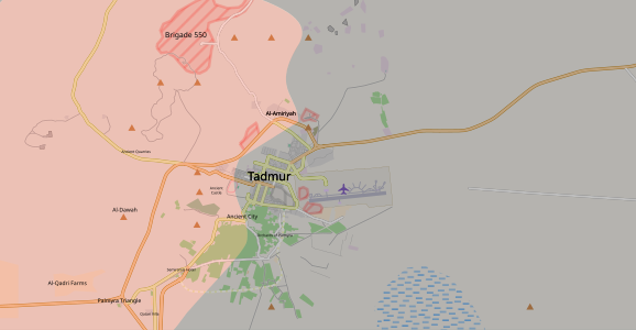
-

.jpg)

.svg)
.svg)
.svg)
_(within_Northern_Syria).svg)
.svg)
.svg)
.svg)
.svg)
.svg)
.png)
.svg)
.svg)
![[3]](https://fbcdn-sphotos-f-a.akamaihd.net/hphotos-ak-frc3/s720x720/580005_351003768298585_1615376483_n.jpg)
![[5]](http://www.lf.bh/photos/100411-1.jpg)
.svg)
.svg)
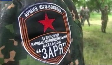
.png)
![[22]](https://7496bff410df41fc380ad565a50f607d4b1e8372.googledrive.com/host/0BzN49CdHSAwmcGU4eEI5dVBGZXM/CizireCantonEN-2015-05-11.png)
.svg)
.svg)
.svg)
.svg)
.svg)
.svg)
.svg)
.png)
.svg)
![[23]](http://www.heraldicum.ru/russia/imagebig/tuva30s.gif)
.svg)
.svg)
.svg&action=edit&redlink=1)
.svg)
![[24]](http://www.heraldicum.ru/russia/imagebig/tuva43.gif)
.svg)
.svg)
.svg)
.svg)
.svg)
![[26]](http://www.crwflags.com/fotw/images/i/ir_pres.jpg)
.svg)
![[28]](https://commons.wikimedia.org/wiki/File:Official_Donetsk_People%27s_Republic_coat_of_arms.png)
![[30]](http://mosvedi.ru/photos/news/12871_big.jpg)
![[31]](https://02varvara.files.wordpress.com/2014/05/00-donetsk-01-24-05-14.jpg?w=1200&h=720)
![[32]](http://ic.pics.livejournal.com/ce48/20124870/198188/198188_900.jpg)
![[33]](http://s009.radikal.ru/i310/1411/7c/c2de5e2ed3f8.jpg)
![[34]](http://s04.radikal.ru/i177/1410/04/ae9db28e9d74.jpg)
![[35]](http://s017.radikal.ru/i429/1410/4f/24a67a0fb8d7.jpg)
![[36]](http://cs617223.vk.me/v617223262/1322a/UubKkbz6dhE.jpg)
![[37]](http://s014.radikal.ru/i326/1410/9d/d85133171ce0.jpg)
![[38]](http://i.ytimg.com/vi/QoZQYrhVIjk/maxresdefault.jpg)
![[39]](https://www.facebook.com/photo.php?fbid=565296450192391&set=pb.434107746644596.-2207520000.1384709394.&type=3&src=https%3A%2F%2Ffbcdn-sphotos-g-a.akamaihd.net%2Fhphotos-ak-ash3%2F1380265_565296450192391_1820595779_n.jpg&size=960%2C539)
![[40]](http://news-mail.by/wp-content/uploads/2015/01/%D0%AD%D0%BC%D0%B1%D0%BB%D0%B5%D0%BC%D0%B0-%D0%93%D0%91%D0%A0-%D0%91%D1%8D%D1%82%D0%BC%D0%B5%D0%BD.jpg)
![[41]](http://4pera.ru/upload/iblock/bde/bdebca47ed7f740c7e2fb659afa26961.jpg)
![[42]](http://rusvesna.su/sites/default/files/styles/orign_wm/public/gbr_0.jpg?itok=TrIPhkFu)
![[43]](http://news.bbcimg.co.uk/media/images/79674000/jpg/_79674532_024327221-1.jpg)
![[46]](http://www.lemkoassociation.org/images/rusyn-flag-picture-crop.jpg)
![[47]](http://patriot-donetsk.ru/uploads/posts/2015-06/1435670687_7t597dbxexy.jpg)
![[48]](http://images3.to-p.net/IMG_0/info/im1-11858.jpg)
![[50]](http://thumb9.shutterstock.com/display_pic_with_logo/83290/230876986/stock-photo-flag-of-donetsk-people-s-republic-with-rain-drops-230876986.jpg)
![[51]](https://upload.wikimedia.org/wikipedia/commons/7/79/2015-05-05._%D0%A0%D0%B5%D0%BF%D0%B5%D1%82%D0%B8%D1%86%D0%B8%D1%8F_%D0%BF%D0%B0%D1%80%D0%B0%D0%B4%D0%B0_%D0%9F%D0%BE%D0%B1%D0%B5%D0%B4%D1%8B_174.jpg)
.svg)
![[52]](https://en.wikipedia.org/wiki/2015_Latakia_offensive#/media/File:2015_Latakia_Frontlines.svg)
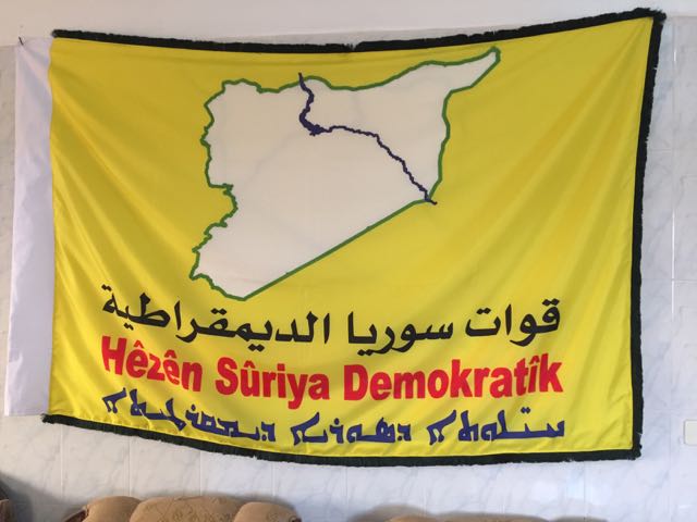
_alternate.svg)
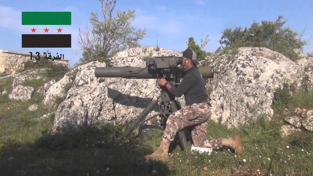
.svg)
.svg&action=edit&redlink=1)
.svg)
.svg)
.svg)
.svg)
.svg)
Hello MrP, I just lightly edited your Raqqa region map in order to add a date -Nov 6th- to your isoline.
I also noticed you have a very good SVG out from OSM. If possible, could you either :
- provide similar svg map for
- (a) Raqqa urban area + margin:10%
- (b) Mosul region
- (c) Mosul urban area + margin:10%
- OR! provide a short tutorial. Such as : url.com > "Download" tab > SVG : full > click.
Thanks, also, for the previous maps. --Yug (talk) 16:58, 7 November 2016 (UTC)
- Ah. Interestingly enough, the date appears on the svg but not on the PNGs. The line being brown, from black, it means Commons' imagemagick processing doesn't handle text-on-path elements. --Yug (talk) 17:06, 7 November 2016 (UTC)

- I previously made the following based on a simple screenshot.
- But without going further south, it's too small for a relevant (b) Mosul region, and too big for a (c) Mosul urban area + margin:10%.
- --Yug (talk) 19:59, 7 November 2016 (UTC)
- Hello Yug! Yes I saw your Mosul map (I particularly like the Key, it has a very professional/sleek look to it). By +margin:10% do you mean a border area around the entirety of the map of about 10%? Sorry if that's a dumb question. MrPenguin20 (talk) 20:14, 8 November 2016 (UTC)
- Also that's a really good idea - adding the date to the boundary itself. May steal idea for future maps... MrPenguin20 (talk) 20:21, 8 November 2016 (UTC)
- See my addition to the gallery. :D
- You don't have to add the contolled areas layers, this will come later as it need some research and sources. But having these 2 backgrounds maps as clean, good quality SVG would be good start. --Yug (talk) 10:24, 9 November 2016 (UTC)
- KK gotcha. No problem! MrPenguin20 (talk) 22:27, 9 November 2016 (UTC)
- I saw your new Raqqa map. Awesome :D
- I also found a Raqqa-city map, so the Raqqa offensive has all the (2) needed background maps so we can document it properly.
- See the upper gallery for details. --Yug (talk) 22:29, 13 November 2016 (UTC)
- Oh yeeeah forgot about that Raqqah Map. I've uploaded a higher definition version anyway (we can delete it if it isn't useful). I've also uploaded Mosul maps here and here. I expanded the 'Mosul surrounds' map further to the West so as to include the PMU westward flank, but I can reduce it if you want. MrPenguin20 (talk) 17:24, 15 November 2016 (UTC)
- Lol. Cool, those are great background materials :D
- I displayed them on the Mosul offensive talkpage.
- As usual on wiki, don't expect them to be used and filled overnight. But they will get use ! --Yug (talk) 11:06, 17 November 2016 (UTC)
- As for the Raqqa region's map, It would be beneficial to keep a table with village name / date of capture, so to add these textual info to the map. I advise to collect this the closest to the wikipedia editorial effort, namely, within the English article's talkpages. Yug (talk) 11:58, 18 November 2016 (UTC)
- Ok. Effort ongoing. I set up sections on both articles talkpage (talk:Battle of Mosul, talk:Raqqa offensive)so a community effort is made to collect data and fill these backgrounds :D --Yug (talk) 12:57, 18 November 2016 (UTC)
- Mosul-area map kickstarted ! We start to be up to date :D --Yug (talk) 17:44, 19 November 2016 (UTC)
- Great job! These are looking great! MrPenguin20 (talk) 17:44, 22 November 2016 (UTC)
- (Data:) I was exhausted after +2~3 hours browsing the web, digging and cross checking for villages names, controls, dates in order to kickstart the Mosul map.
- Neither Google nor OSM provides sufficient names for the various "villages" in the areas.
- Now aware of the issue, the best map sources I found for villages' English names are this for Rakka, and this (map) for Mosul's battle. Based on these two, we can further improve either our SVG or directly OSM (but I haven't yet).
- Also, the design deserves better.
- Last, I started to connect with the English Map Workshop. The workshop gather good willed map makers and a hand of talented ones.
- All together our community of graphists now can raise up these needy battle maps to the best wikipedia standards, on both graphic and data sides :D Yug (talk) 11:15, 23 November 2016 (UTC)
- Great ideas! I personally tend to use Wikimapia - it gets updated quite regularly, and marks everything to a high degree of detail. MrPenguin20 (talk) 11:53, 25 November 2016 (UTC)
- Great job! These are looking great! MrPenguin20 (talk) 17:44, 22 November 2016 (UTC)
- Mosul-area map kickstarted ! We start to be up to date :D --Yug (talk) 17:44, 19 November 2016 (UTC)
- Oh yeeeah forgot about that Raqqah Map. I've uploaded a higher definition version anyway (we can delete it if it isn't useful). I've also uploaded Mosul maps here and here. I expanded the 'Mosul surrounds' map further to the West so as to include the PMU westward flank, but I can reduce it if you want. MrPenguin20 (talk) 17:24, 15 November 2016 (UTC)
- Oh god. I added the Palmyra battles ! Do they ever stop to do war???? XD
- Maybe we should move these galleries and talk on the English Graphic lab. Yug (talk) 18:58, 30 December 2016 (UTC)
- Oh! Did I told you Kami888 seems to be handling up the Mosul map ^^
- Also, on the Raqqa maps, I removed the black opacity 20% layer, and the maps looks better to read. I also add take over dates now with { color:white;font-weight:bold; }. You may like this usage. --Yug (talk) 19:13, 30 December 2016 (UTC)
.svg)
.svg)
.svg)
Kafr Saghir Martyrs Brigade flag edit
Hello MrPenguin20,
I think before talking about the point it's just legit to give you this:
|
|
The Graphic Designer's Barnstar |
| For your great works and seemingly neverending diligence--Ermanarich (talk) 15:26, 1 December 2016 (UTC) |
So the point I wanted to talk about is, that I created an article for the Kafr Saghir Martyrs Brigade, but it still needs the flag. This is the flag of the KSMB: [53], [54]. I would probably try to do it, but I'm not familiar with Arabic at all, so I wanted to ask you if it's possible for you to do it.
Kind regards, Ermanarich (talk) 15:26, 1 December 2016 (UTC)
- Nevermind. The page hasn't been created yet, since other users view this militia as not notable enough.--Ermanarich (talk) 23:42, 1 December 2016 (UTC)
- I'll make it for you anyway! You never know when these things might come in handy in future. MrPenguin20 (talk) 10:25, 9 December 2016 (UTC)
- That's the emblem done so far, seen here. MrPenguin20 (talk) 00:34, 13 December 2016 (UTC)
- I'll make it for you anyway! You never know when these things might come in handy in future. MrPenguin20 (talk) 10:25, 9 December 2016 (UTC)
Emblem of the Military Security Shield Forces edit
Hello MrPenguin20,
I have created a new article for a pro-government militia in Syria, the Military Security Shield Forces, and wanted to ask you kindly if you could create the group's emblem for the article. You can find the emblem here: [55] If you don't have time that is not a problem. ^^ Applodion (talk) 00:09, 14 December 2016 (UTC)
- Sure, no problem! MrPenguin20 (talk) 11:34, 14 December 2016 (UTC)
- Awesome, thanks! Applodion (talk) 18:53, 14 December 2016 (UTC)
- took a little while (sorry) - but it's up now! and is uploaded here. MrPenguin20 (talk) 13:49, 31 December 2016 (UTC)
- Wow! Thanks! Good work! Applodion (talk) 23:07, 1 January 2017 (UTC)
- took a little while (sorry) - but it's up now! and is uploaded here. MrPenguin20 (talk) 13:49, 31 December 2016 (UTC)
- Awesome, thanks! Applodion (talk) 18:53, 14 December 2016 (UTC)
.svg)
Northern Raqqa offensive edit
Hello, can you update the Northern Raqqa offensive map? The second phase started on 10 December and SDF have captured 20 villages since then in its western countryside and advancing along the western road. I'm sure you can find sources online by yourself for it. Please do update it. 124.253.252.212 11:54, 16 December 2016 (UTC)
- Done. --Yug (talk) 19:17, 19 December 2016 (UTC)
- Generally speaking, I handle this one. Yug (talk) 19:48, 30 December 2016 (UTC)
|
|
File:Coat of Arms of the Donetsk People's Republic.svg has been listed at Commons:Deletion requests so that the community can discuss whether it should be kept or not. We would appreciate it if you could go to voice your opinion about this at its entry.
If you created this file, please note that the fact that it has been proposed for deletion does not necessarily mean that we do not value your kind contribution. It simply means that one person believes that there is some specific problem with it, such as a copyright issue. Please see Commons:But it's my own work! for a guide on how to address these issues. |
Battle of Al-Bab map edit
_(within_Northern_Syria).svg)
The Turks and rebels only temporarily (for less than a day) controlled Bzaah and Qabasin. ISIL quickly recaptured them and they are still ISIL-held (source - [56]). The main Wikipedia Syrian civil war map is also reflecting this. So could you please adjust the map accordingly? Thanks! EkoGraf (talk) 18:19, 19 February 2017 (UTC)
- Hi EkoGraf, thanks for pointing this out. I think it's sounding like this may have been reversed again, and that al-Bab has totally been taken. MrPenguin20 (talk) 15:31, 23 February 2017 (UTC)
Hi Penguin, The battle of Al-Bab is heating up these day. Can you copte with the workload ? I'am up to date on the Raqqa 3~4 fronts and could help on this Al-Bab map. I would also like to add some chronolines. --Yug (talk) 10:46, 28 February 2017 (UTC)
- Yeah I was waiting for final confirmation on the disappearance of the ISIS pocket west of Jub al-Khafi, but it sounds like it's gone so I've uploaded the map I had waiting. If you wanted to add chronolines though that'd be great! MrPenguin20 (talk) 11:05, 28 February 2017 (UTC)
- I collected my sources on File_talk:Western_al-Bab_offensive_(2016)_(within_Northern_Syria).svg. I think more detail could be added, but it's my opinion / taste. --Yug (talk) 11:12, 28 February 2017 (UTC)
- No I agree. I think the area to the west of Lake Assad will also have to be updated for more information on towns/villages/roads etc in anticipation on the Govt & SDF advances in the area. MrPenguin20 (talk) 11:24, 28 February 2017 (UTC)
- The number of moves on this front is impressive. I got too much things here in real life (job / private), I currently cannot port these changes on the commons's svg. Yug (talk) 16:49, 1 March 2017 (UTC)
_(within_Northern_Syria).svg)
Raqqa edit
.svg)
Hello Penguin,
The en:Northern Raqqa offensive (November 2016–present) map's background start to be too small folowwing the recent offensive between Raqqa and Dez-zor. See syriancivilwarmap.com for details. Could you provide us a new larger background on the eastern side ? An alternative proposal will do as well. I think the same zoom, but shifting 30km eastward could do, It would barely include the Assad lake on the West, and allows to include the new eastern front on the Eastern limit. --Yug (talk) 11:40, 20 February 2017 (UTC)
- No problemo! MrPenguin20 (talk) 15:20, 23 February 2017 (UTC)
- It's been 4 days now MrPenguin. Please enlarge it. If you cannot, then please say so. I'll try it myself as I have a little bit of knowledge about svg maps. MonsterHunter32 (talk) 06:26, 24 February 2017 (UTC)
- I've increased it. It was a bit trickier than just expanding the map eastward (if only), as it required a new topographic map and also including infrastructure for the new areas. Then in turn wikicommons doesn't accept maps over a certain size (they just won't show), so I had to reduce the filesize. It's been expanded/uploaded, but there's a couple issues which I'm currently still adjusting. MrPenguin20 (talk) 19:08, 24 February 2017 (UTC)
- Feel free in future to change anything in future though - seriously! I can be quite busy/not have access to a mouse (which is needed for doing more fiddly things, e.g. this), so if you think I'm being too slow/etc then feel free to fix things yourself as well! MrPenguin20 (talk) 19:18, 24 February 2017 (UTC)
- Thanks MrPenguin ! :D I don't know how you do those, I was GIS mapping in the early 2012, OSM data was a mess to extract. It could be good to share your trick, a tiny bullet list how to. Yug (talk) 19:23, 24 February 2017 (UTC)
- Oh, I saw the tiny sliding on the map. I come on those asap (but likely Tuesday only due to the weekend) --Yug (talk) 19:26, 24 February 2017 (UTC)
- Ah it's not so bad. I tend to use US Govt topographic maps, then use a palettecolour (which I think is the default one we're supposed to use on wiki), then I align openstreetmap on top. QGIS has an openstreetmap import function, but it always imports with waaaay too much detail. Is that far east enough? Inside the file it goes as far south as Deir Ezzor as well (just incase!). MrPenguin20 (talk) 19:37, 24 February 2017 (UTC)
- I document the SDF's moves as well as I can do as a volunteer. My Weekend is just ending, I did a quick update and didn't made a careful review of your background (geographic range, quality), but seems good for now. If needed, the background can be beautified later on. Will see as needed. Yug (talk) 20:44, 26 February 2017 (UTC)
Lugansk and Donetsk edit
Hi Have you got sources about Lugansk and Donetsk flags since February 2014 and the different changes. Also, according to Lugansk website, now there are coats of arms in Lugansk flag. Also, what are the sources about November 2014 flag ? --Panam2014 (talk) 12:56, 26 February 2017 (UTC)
|
|
File:New Donetsk Peoples Republic flag.svg has been listed at Commons:Deletion requests so that the community can discuss whether it should be kept or not. We would appreciate it if you could go to voice your opinion about this at its entry.
If you created this file, please note that the fact that it has been proposed for deletion does not necessarily mean that we do not value your kind contribution. It simply means that one person believes that there is some specific problem with it, such as a copyright issue. Please see Commons:But it's my own work! for a guide on how to address these issues. |
Hello there Penguin and thanks for your contributions. While observing the map listed in the title, I have noticed a strange anomaly. The portion of Aleppo city never seems to have been updated and rebels are shown to be still under control of some area in eastern portion of Aleppo city, however they already surrendered it in December 2016 and left eastern Aleppo city. Please correct this and update it. Thanks a lot. MonsterHunter32 (talk) 19:50, 1 March 2017 (UTC)
_(within_Northern_Syria).svg)
- Oh my goodness I can't believe I never noticed the map was still showing that area under Opp control! Thanks for bringing this up! MrPenguin20 (talk) 22:12, 1 March 2017 (UTC)
Variant flag of Lugansk (april-november 2014) edit
Hi Exempleand Exemple Could you made that variant of flags of LNR ? --Panam2014 (talk) 18:54, 5 March 2017 (UTC)
PGT flag edit
Greetings, Mr. Penguin. I notice that you created these two images [57] and [58], both to do with the PGT in Guatemala. Do you happen to have any information about the copyright status of these symbols? I'm trying to incorporate them into articles on the English Wikipedia, and so this information is necessary. Regards, Vanamonde93 (talk) 11:12, 15 March 2017 (UTC)
![[57]](https://commons.wikimedia.org/wiki/File:Partido_Guatemalteco_del_Trabajo_(flag).svg)
![[58]](https://en.wikipedia.org/wiki/File:Partido_Guatemalteco_del_Trabajo_(logo).svg)
- Hi Vanamonde93! They're currently under the Creative Commons Attribution-Share 3.0 (that's the default whenever you upload), however I'd hazard that they're public domain. The Hammer-Sickle-Star is identical to numerous other communist flags and logos, and the text alone isn't enough to give it it's own copyright. MrPenguin20 (talk) 00:40, 16 March 2017 (UTC)
- Thank you! Vanamonde93 (talk) 05:44, 18 March 2017 (UTC)
File:Emblem of the People's Mujahedin of Iran.svg edit
The date of the foundation of the organization in this image is not correct. This date reads 1322, but the correct date is 1344, according to the official logo on the organization website. Please review. Thanks. Gharouni (talk) 12:19, 18 March 2017 (UTC)
 |
File:New Donetsk Peoples Republic flag.svg has been marked as a possible copyright violation. Wikimedia Commons only accepts free content—that is, images and other media files that can be used by anyone, for any purpose. Traditional copyright law does not grant these freedoms, and unless noted otherwise, everything you find on the web is copyrighted and not permitted here. For details on what is acceptable, please read Commons:Licensing. You may also find Commons:Copyright rules useful, or you can ask questions about Commons policies at the Commons:Help desk. If you are the copyright holder and the creator of the file, please read Commons:But it's my own work! for tips on how to provide evidence of that.
The file you added may soon be deleted. If you have written permission from the copyright holder, please replace the copyvio tag with {{subst:OP}} and have them send us a free license release via COM:VRT. If you disagree that the file is a copyright violation for any other reason, please replace the copyvio tag with a regular deletion request. Warning: Wikimedia Commons takes copyright violations very seriously and persistent violators will be blocked from editing.
|
|
|
File:New Donetsk Peoples Republic flag.svg has been listed at Commons:Deletion requests so that the community can discuss whether it should be kept or not. We would appreciate it if you could go to voice your opinion about this at its entry.
If you created this file, please note that the fact that it has been proposed for deletion does not necessarily mean that we do not value your kind contribution. It simply means that one person believes that there is some specific problem with it, such as a copyright issue. Please see Commons:But it's my own work! for a guide on how to address these issues. |
Map uploads edit
Hi,
Please can you take care to correctly source files when uploading maps like File:Aberdeen City Council election 1992.svg or File:2017 Khan Shaykhun chemical attack frontlines.svg. You have created the final file in both of these cases, but they not your entirely "own work" as they are derived from other sources. Failure to correctly attribute the source can mean the files are technically in violation of copyright.
With the Aberdeen file, its clearly derived from one of mine, so it should indicate that fact. Its also using a couple of additional sources: Where did you get the ward boundaries and results from? With the Syrian map, where did you get the base map, and the information on the front line? Those questions should be answered by the source section, else the file will not meet Wikipedia's verification requirement.
.svg)
As for the copyright elements, one of the requirements of using OS OpenData is OS is attributed in a set manner. My file shows a suitable way to attribute OS, and also appropriate sourcing information; {{OS OpenData}} could also be used. The base of the Syrian map looks like OpenStreetMap, if so OSM should be attributed for that (via {{OpenStreetMap}} or similar).--Nilfanion (talk) 09:37, 5 April 2017 (UTC)
- Hi Nilfanion - sorry you're right. I do often attribute the underlying svg's I've used - e.g. here, but when I do a bulk upload of maps it often gets missed. I'll go through them and make sure they're properly marked. MrPenguin20 (talk) 13:11, 5 April 2017 (UTC)
Hama offensive map update edit
MrPenguin please update the map for this article https://en.wikipedia.org/wiki/2017_Hama_offensive - as SAA captured Halfaya and vicinities at 23 April. Thank you — Preceding unsigned comment was added by 78.88.29.68 (talk) 15:07, 4 May 2017 (UTC)
UK local elections map edit
Hello. Brilliant map! May I ask on which original file it is based? And also, I note that the svg file has no id descriptions for individual counties and wards (all ids are in figures only) - do you have a kind of a table indicating which path on the map corresponds to which county/ward? Thanks. Ivan Volodin (talk) 12:55, 5 May 2017 (UTC)
- Hi Ivan Volodin! Argh yes it really should say - the base map is made using resources from the Ordnance Survery website (England Wales NI and Scottish council boundaries), then the Scottish wards use resources from the Scottish Government Local Boundary Commission. The Council control is from the BBC - Scotland, England and Wales, and then ward results are really coming from the individual councils when they come out - the BBC is featuring some of these, e.g. Worcestershire. Hope that helps! Let me know if you've got any other questions/if I've badly answered you current q! MrPenguin20 (talk) 13:07, 5 May 2017 (UTC)
- Looks like the BBC's also got a map of council control! Although it doesn't show ward results. MrPenguin20 (talk) 13:08, 5 May 2017 (UTC)
- Yes, thanks. I actually meant to ask whether there exists (on Wikipedia/Commons, or whether you may be willing to upload) a blank map with wards, with one UK on it rather than two :) And also, how do you actually fill the ward results - I presume you are not editing the svg code with your hands? This is not to challenge the accuracy, but in order to be able to work with the map myself. Ivan Volodin (talk) 13:38, 5 May 2017 (UTC)
- Yes please do feel free to add/vary! I use Inkscape to edit svg's personally - it's free, and quite easy to use (almost like paint for svg's). I don't think there's any maps on wikicommons showing just the wards, but I could upload another version with just the the version of the UK on the right if you want? What would you want me to name it? MrPenguin20 (talk) 14:26, 5 May 2017 (UTC)
Base for electoral maps edit
Hi, I'd like to point out my strong preference for using a "richer" base map for electoral results: As these show the context better. To me, the key factor is the coastline - districts aren't islands - omitting it can cause misinterpretation of what the place is. Furthermore as OS data is extent-of-the-realm, but it really needs to be clipping to the coast. Bristol is the most extreme, but others from Aberdeen to Brighton have unnatural extensions. The high-tide line is the one to use - South Holland then follows the edge of the Wash instead of jutting out to include some of the sandbanks.
Other things like the insets add value too, but are less pertinent.--Nilfanion (talk) 09:54, 15 May 2017 (UTC
- A very fair point. My only worry would be that clipping to the coast is going to increase the map complexity, thereby making the filesize larger (and I believe wikicommons seems to have issues sometimes with files over 10mb). I shall give it a try though as I definitely agree it would be preferable. MrPenguin20 (talk) 14:48, 24 May 2017 (UTC)
Enjoy a bottomless pint of Fuller's London Pride edit

|
BEER! |
| Thanks for your file United Kingdom general election 1885 (within London & Middlesex) Adam37 (talk) 19:35, 10 June 2017 (UTC) |
- Haha thank you! I've got a full 1885 map in the works, but thought it made sense to also release parts in segments as they get finished too. MrPenguin20 (talk) 12:24, 13 June 2017 (UTC)
Help with an SVG edit
Hey Penguin, I'm here to ask help with Fill Patterns. I'm specifically reusing United_Kingdom_general_election_1830.svg and I want to edit the fill pattern to change the colours in the fill patterns from Tory Blue and Whig Orange to Tory Blue and Labour Red. How would I go about this as I'm having trouble with getting "Objects to pattern" working properly Harry26548 (talk)
- Hi Harry26548! Sorry for the delayed response - just back from holiday. Yeah pattern's can be a bit of a pain. If you're using Inkscape then the way to do it would be to select an object filled with the Tory Blue & Whig Orange pattern and then use -
Extensions > Colour > Replace Colour
- A menu should appear. In the "Replace Colour" box you enter the Whig Orange hex code (FFA500), and in the "By Colour" box enter the Labour Red hex code (DC241F I think). Then press "Apply" and presto - should have successfully replaced the colour. This should then create an entirely new pattern made up of the Tory Blue and Labour Red colour, which can then be used elsewhere. Hope that helps! If you're still having trouble I can upload a new version of the file with a pattern in there that you can use elsewhere in the map/in other files. Let me know how it goes. MrPenguin20 (talk) 17:39, 30 June 2017 (UTC)
Vertical Flag of Egypt edit
Hello my dear friend. Do you mind uploading a svg copy for File:Vertical Flag of Egypt.png? Thanks.--Avocato (talk) 02:47, 21 July 2017 (UTC)
- Sorry was away! Looks like you got there first. MrPenguin20 (talk) 17:49, 29 July 2017 (UTC)
- Never mind. Can you do it anyway? :) --Avocato (talk) 18:28, 31 July 2017 (UTC)
New flag of Jaysh al-Thuwar edit


Hi MrPenguin, would you mind uploading the new flag of Jaysh al-Thuwar in SVG form? It's based on the flag of the SDF. Thanks. Editor abcdef (talk) 01:49, 7 October 2017 (UTC)
- No problem! MrPenguin20 (talk) 18:06, 10 October 2017 (UTC)
SDF Deir Ez Zor Map edit
Can you make A Deir Ez Zor Map showing SDF advance in SDF's Deir Ez Zor offensive, but with the format similiar to that of the Afrin Offensive map,please AlAboud83 (talk) 16:15, 29 April 2018 (UTC)
Like this format,the Hasakah Map here https://commons.wikimedia.org/wiki/File:Southern_Al-Hasakah_offensive_(2015).svg ,i tried to make one on inkscape,but it is very complicated.AlAboud83 (talk) 16:18, 29 April 2018 (UTC)
.svg)
- Sure :) MrPenguin20 (talk) 19:49, 1 May 2018 (UTC)
How is the map going.AlAboud83 (talk) 15:28, 13 May 2018 (UTC)
- Little delayed - but almost finished :P MrPenguin20 (talk) 15:34, 13 May 2018 (UTC)
How is the map going.AlAboud83 (talk) 16:30, 20 May 2018 (UTC)
Text on the Afrin Canton flag is innaccurate edit
I noticed while looking for informaton on Rojavan-Northern Syrian flags that the text on the flag of Afrin Canton appears to be innaccurate.
The flag and coat of arms have "Kantona Afrin" when it appears the correct Kurdish text would be "Kantona Efrînê". Heres the official Afrin Canton website with an image of the flag 
And heres a photo containing the flag from the battle of Afrin (text not clearly visible, but it there appears to be an E at the beginning of the second word)
Could you edit the current files to have the correct Kurdish text?
Thank you for all of the work you have done, especially regarding your work on flags. Thespoondragon (talk) 04:59, 2 May 2018 (UTC)
SVG version edit
Hi Could you upload an svg version of Flag_used_by_Tihamah_resistance.jpg--Panam2014 (talk) 13:36, 24 June 2018 (UTC)
| |
Wikimedia Commons does not accept fair use content.
We do this because Commons is a shared media repository. Downstream wikis have different policies based on local laws. Uses that are acceptable under US law, for example, may not be acceptable in many other countries with more restrictive rules. In addition, fair use is not compatible with our aim as a collection of freely distributable media files. Therefore, Commons cannot legally rely on fair use provisions. Non-free content that may be used with reference to fair use may be uploaded locally if your project allows this.
|
Yours sincerely, ديفيد عادل وهبة خليل 2 (talk) 08:20, 8 September 2018 (UTC)
|
|
File:Flag of the Ghost Brigade.svg has been listed at Commons:Deletion requests so that the community can discuss whether it should be kept or not. We would appreciate it if you could go to voice your opinion about this at its entry.
If you created this file, please note that the fact that it has been proposed for deletion does not necessarily mean that we do not value your kind contribution. It simply means that one person believes that there is some specific problem with it, such as a copyright issue. Please see Commons:But it's my own work! for a guide on how to address these issues. |
Notification about possible deletion edit
|
|
Some contents have been listed at Commons:Deletion requests so that the community can discuss whether they should be kept or not. We would appreciate it if you could go to voice your opinion about this at their entry.
If you created these pages, please note that the fact that they have been proposed for deletion does not necessarily mean that we do not value your kind contribution. It simply means that one person believes that there is some specific problem with them, such as a copyright issue. Please see Commons:But it's my own work! for a guide on how to address these issues. |
Affected:
And also:
- File:ARVN Armored Cavalry Regiment Flag.svg
- File:ARVN Joint General Staff Insignia.svg
- File:Flag of ARVN Junior Military Academy.svg
- File:Flag of ARVN Military Engineering Forces.svg
- File:Flag of Dong De Military School.svg
- File:Flag of Security Force of Capital Special Zone.svg
- File:Flag of the ARVN 25th Division.svg
- File:Flag of the ARVN 2nd Division.svg
- File:Flag of the ARVN 3rd Infantry Division.svg
- File:Flag of the ARVN 7th Infantry Division.svg
- File:Flag of the ARVN 9th Infantry Division.svg
- File:Flag of the ARVN Airborne Division.svg
- File:Flag of the ARVN I Corps.svg
- File:Flag of the ARVN II Corps.svg
- File:Flag of the ARVN III Corps.svg
- File:Flag of the ARVN IV Corps.svg
- File:Flag of the President of the Republic of Vietnam as Supreme Commander of the Armed Forces.svg
- File:Flag of the Republic of Vietnam Marine Division.svg
- File:Flag of the RVNMF.svg
- File:Quang Trung National Training Center Flag.svg
- File:Republic of Vietnam Marine Division SSI.png
- File:RVN National Police Flag.svg
- File:Vietnamese Rangers Flag.svg
- File:Vietnamese Rangers SSI.svg
- File:War flag of South Vietnam.svg
Yours sincerely, please check the deletion request page for your image(s) uploaded per PD-VietnamGov minhhuy (talk) 03:28, 8 April 2019 (UTC)
|
|
File:Badge of the Royal Ulster Constabulary.svg has been listed at Commons:Deletion requests so that the community can discuss whether it should be kept or not. We would appreciate it if you could go to voice your opinion about this at its entry.
If you created this file, please note that the fact that it has been proposed for deletion does not necessarily mean that we do not value your kind contribution. It simply means that one person believes that there is some specific problem with it, such as a copyright issue. Please see Commons:But it's my own work! for a guide on how to address these issues. |
|
|
File:Seal of the National Intelligence and Security Service.svg has been listed at Commons:Deletion requests so that the community can discuss whether it should be kept or not. We would appreciate it if you could go to voice your opinion about this at its entry.
If you created this file, please note that the fact that it has been proposed for deletion does not necessarily mean that we do not value your kind contribution. It simply means that one person believes that there is some specific problem with it, such as a copyright issue. Please see Commons:But it's my own work! for a guide on how to address these issues. |
.svg)
.svg)
|
|
File:Flag of the People's Mujahedin of Iran (Yellow).svg has been listed at Commons:Deletion requests so that the community can discuss whether it should be kept or not. We would appreciate it if you could go to voice your opinion about this at its entry.
If you created this file, please note that the fact that it has been proposed for deletion does not necessarily mean that we do not value your kind contribution. It simply means that one person believes that there is some specific problem with it, such as a copyright issue. Please see Commons:But it's my own work! for a guide on how to address these issues. |
.svg)
.svg)
|
|
File:Flag of the People's Mujahedin of Iran.svg has been listed at Commons:Deletion requests so that the community can discuss whether it should be kept or not. We would appreciate it if you could go to voice your opinion about this at its entry.
If you created this file, please note that the fact that it has been proposed for deletion does not necessarily mean that we do not value your kind contribution. It simply means that one person believes that there is some specific problem with it, such as a copyright issue. Please see Commons:But it's my own work! for a guide on how to address these issues. |
| File:Flag of the Azov Battalion.svg has been marked for speedy deletion. A reason for the tagging has not been detected or none was placed.
Why not upload a picture of a plant, animal, or anything else which fits into our scope. You can contribute any media type you want, including but not limited to images, videos, music, and 3D models. Start uploading now ! If you don't have anything to upload at the moment, why not take a look at our best images or best videos, sounds and 3D models. If you have any doubts/questions don't hesitate to visit our help desk. |
I'm a computer program; please don't ask me questions but ask the user who nominated your file(s) for deletion or at our Help Desk. //Deletion Notification Bot (talk) 14:45, 28 September 2020 (UTC)
|
|
File:Hashem al Atta, Khalid Hassan Abbas, 1971 Sudanese coup d'état.jpg has been listed at Commons:Deletion requests so that the community can discuss whether it should be kept or not. We would appreciate it if you could go to voice your opinion about this at its entry.
If you created this file, please note that the fact that it has been proposed for deletion does not necessarily mean that we do not value your kind contribution. It simply means that one person believes that there is some specific problem with it, such as a copyright issue. Please see Commons:But it's my own work! for a guide on how to address these issues. |
|
|
File:Emblem of the Ministry of Defence of Afghanistan.svg has been listed at Commons:Deletion requests so that the community can discuss whether it should be kept or not. We would appreciate it if you could go to voice your opinion about this at its entry.
If you created this file, please note that the fact that it has been proposed for deletion does not necessarily mean that we do not value your kind contribution. It simply means that one person believes that there is some specific problem with it, such as a copyright issue. Please see Commons:But it's my own work! for a guide on how to address these issues. |
― Tartan357 Talk 01:28, 29 December 2021 (UTC)
|
|
File:Coat of Arms of the Donetsk People's Republic.svg have been listed at Commons:Deletion requests so that the community can discuss whether they should be kept or not. We would appreciate it if you could go to voice your opinion about this at their entry.
If you created these pages, please note that the fact that they have been proposed for deletion does not necessarily mean that we do not value your kind contribution. It simply means that one person believes that there is some specific problem with them, such as a copyright issue. Please see Commons:But it's my own work! for a guide on how to address these issues. |
.svg)
| |
File:Flag of the Donetsk Republic (Organisation).svg has been marked as a possible copyright violation. Wikimedia Commons only accepts free content—that is, images and other media files that can be used by anyone, for any purpose. Traditional copyright law does not grant these freedoms, and unless noted otherwise, everything you find on the web is copyrighted and not permitted here. For details on what is acceptable, please read Commons:Licensing. You may also find Commons:Copyright rules useful, or you can ask questions about Commons policies at the Commons:Help desk. If you are the copyright holder and the creator of the file, please read Commons:But it's my own work! for tips on how to provide evidence of that.
The file you added may soon be deleted. If you have written permission from the copyright holder, please replace the copyvio tag with {{subst:OP}} and have them send us a free license release via COM:VRT. If you disagree that the file is a copyright violation for any other reason, please replace the copyvio tag with a regular deletion request.
|
.svg)
|
|
File:Flag of the Donetsk Republic (Organisation).svg has been listed at Commons:Deletion requests so that the community can discuss whether it should be kept or not. We would appreciate it if you could go to voice your opinion about this at its entry.
If you created this file, please note that the fact that it has been proposed for deletion does not necessarily mean that we do not value your kind contribution. It simply means that one person believes that there is some specific problem with it, such as a copyright issue. Please see Commons:But it's my own work! for a guide on how to address these issues. |
.svg)
|
|
File:British Freedom Party Logo.svg has been listed at Commons:Deletion requests so that the community can discuss whether it should be kept or not. We would appreciate it if you could go to voice your opinion about this at its entry.
If you created this file, please note that the fact that it has been proposed for deletion does not necessarily mean that we do not value your kind contribution. It simply means that one person believes that there is some specific problem with it, such as a copyright issue. Please see Commons:But it's my own work! for a guide on how to address these issues. |
|
|
File:Emblem of the Afghan Air Force.svg has been listed at Commons:Deletion requests so that the community can discuss whether it should be kept or not. We would appreciate it if you could go to voice your opinion about this at its entry.
If you created this file, please note that the fact that it has been proposed for deletion does not necessarily mean that we do not value your kind contribution. It simply means that one person believes that there is some specific problem with it, such as a copyright issue. Please see Commons:But it's my own work! for a guide on how to address these issues. |
Hello MrPenguin20, I have noticed that in this election map two or three constituencies in in the Scottish Highlands and the Outer Hebrides are colorized in an undefined colour. Is this correct? --Furfur ⁂ Diskussion 19:46, 22 June 2022 (UTC)
| |
File:Emblem of the Sudan People's Democratic Front.svg has been marked as a possible copyright violation. Wikimedia Commons only accepts free content—that is, images and other media files that can be used by anyone, for any purpose. Traditional copyright law does not grant these freedoms, and unless noted otherwise, everything you find on the web is copyrighted and not permitted here. For details on what is acceptable, please read Commons:Licensing. You may also find Commons:Copyright rules useful, or you can ask questions about Commons policies at the Commons:Help desk. If you are the copyright holder and the creator of the file, please read Commons:But it's my own work! for tips on how to provide evidence of that.
The file you added has been deleted. If you have written permission from the copyright holder, please have them send us a free license release via COM:VRT. If you believe that the deletion was not in accordance with policy, you may request undeletion. (It is not necessary to request undeletion if using VRT; the file will be automatically restored at the conclusion of the process.) Warning: Wikimedia Commons takes copyright violations very seriously and persistent violators will be blocked from editing.
|
|
|
File:General Ali Haidar.jpg has been listed at Commons:Deletion requests so that the community can discuss whether it should be kept or not. We would appreciate it if you could go to voice your opinion about this at its entry.
If you created this file, please note that the fact that it has been proposed for deletion does not necessarily mean that we do not value your kind contribution. It simply means that one person believes that there is some specific problem with it, such as a copyright issue. Please see Commons:But it's my own work! for a guide on how to address these issues. |
|
|
File:Flag of the Sham Legion.svg has been listed at Commons:Deletion requests so that the community can discuss whether it should be kept or not. We would appreciate it if you could go to voice your opinion about this at its entry.
If you created this file, please note that the fact that it has been proposed for deletion does not necessarily mean that we do not value your kind contribution. It simply means that one person believes that there is some specific problem with it, such as a copyright issue. Please see Commons:But it's my own work! for a guide on how to address these issues. |
Scotland Lieutenancy Areas map edit
Hey! I saw your map of Scotlands districts from 1975-1996 and I was wondering if you can use that map to make a map of the lieutenancy areas of Scotland since the majority of them are essentially combined districts. I attached a link to the map with the current lieutenancy areas I found online for the areas that don't correspond to a district like Baffnshire or Kincardineshire + some other minor border adjustments. I know a map currently exists but the borders aren't detailed like yours. Thank you for hearing me out!
https://gazetteer.org.uk/ABC_Fact_Sheet_Lieutenancy_Areas_Scotland.pdf
The lieutenancy areas of Banffshire and Kincardineshire are essentially the same as their pre 1975 county borders (with the exception of the parts of Aberdeen in Kincardineshire). Aimmella12 (talk) 02:52, 23 July 2023 (UTC)
|
|
File:Flag of the Kharkov People's Republic.svg has been listed at Commons:Deletion requests so that the community can discuss whether it should be kept or not. We would appreciate it if you could go to voice your opinion about this at its entry.
If you created this file, please note that the fact that it has been proposed for deletion does not necessarily mean that we do not value your kind contribution. It simply means that one person believes that there is some specific problem with it, such as a copyright issue. Please see Commons:But it's my own work! for a guide on how to address these issues. |
|
|
File:Flag of the Kharkov People's Republic.svg has been listed at Commons:Deletion requests so that the community can discuss whether it should be kept or not. We would appreciate it if you could go to voice your opinion about this at its entry.
If you created this file, please note that the fact that it has been proposed for deletion does not necessarily mean that we do not value your kind contribution. It simply means that one person believes that there is some specific problem with it, such as a copyright issue. Please see Commons:But it's my own work! for a guide on how to address these issues. |
Notification about possible deletion edit
|
|
Some contents have been listed at Commons:Deletion requests so that the community can discuss whether they should be kept or not. We would appreciate it if you could go to voice your opinion about this at their entry.
If you created these pages, please note that the fact that they have been proposed for deletion does not necessarily mean that we do not value your kind contribution. It simply means that one person believes that there is some specific problem with them, such as a copyright issue. Please see Commons:But it's my own work! for a guide on how to address these issues. |
Affected:
Yours sincerely, The Squirrel Conspiracy (talk) 08:51, 24 October 2023 (UTC)
|
|
File:Emblem of the 1st Coastal Division.svg has been listed at Commons:Deletion requests so that the community can discuss whether it should be kept or not. We would appreciate it if you could go to voice your opinion about this at its entry.
If you created this file, please note that the fact that it has been proposed for deletion does not necessarily mean that we do not value your kind contribution. It simply means that one person believes that there is some specific problem with it, such as a copyright issue. Please see Commons:But it's my own work! for a guide on how to address these issues. |
The Squirrel Conspiracy (talk) 05:23, 25 February 2024 (UTC)
|
|
File:Flag of the Islamic Jihad Movement in Palestine.svg has been listed at Commons:Deletion requests so that the community can discuss whether it should be kept or not. We would appreciate it if you could go to voice your opinion about this at its entry.
If you created this file, please note that the fact that it has been proposed for deletion does not necessarily mean that we do not value your kind contribution. It simply means that one person believes that there is some specific problem with it, such as a copyright issue. Please see Commons:But it's my own work! for a guide on how to address these issues. |
The Squirrel Conspiracy (talk) 05:25, 25 February 2024 (UTC)
|
|
File:Iraqi Ground Forces Emblem.svg has been listed at Commons:Deletion requests so that the community can discuss whether it should be kept or not. We would appreciate it if you could go to voice your opinion about this at its entry.
If you created this file, please note that the fact that it has been proposed for deletion does not necessarily mean that we do not value your kind contribution. It simply means that one person believes that there is some specific problem with it, such as a copyright issue. Please see Commons:But it's my own work! for a guide on how to address these issues. |
|
|
File:Special Operations Iraq SSI.svg has been listed at Commons:Deletion requests so that the community can discuss whether it should be kept or not. We would appreciate it if you could go to voice your opinion about this at its entry.
If you created this file, please note that the fact that it has been proposed for deletion does not necessarily mean that we do not value your kind contribution. It simply means that one person believes that there is some specific problem with it, such as a copyright issue. Please see Commons:But it's my own work! for a guide on how to address these issues. |