File:SOUTH ELEVATION FROM MANONO STREET - Wailoa Bridge, Spanning Wailoa River at Kamehameha Avenue, Hilo, Hawaii County, HI HAER HI,1-HILO,1-15.tif

Size of this JPG preview of this TIF file: 746 × 600 pixels. Other resolutions: 299 × 240 pixels | 597 × 480 pixels | 955 × 768 pixels | 1,273 × 1,024 pixels | 2,547 × 2,048 pixels | 4,944 × 3,976 pixels.
Original file (4,944 × 3,976 pixels, file size: 18.75 MB, MIME type: image/tiff)
Captions
Captions
Add a one-line explanation of what this file represents
Summary edit
| SOUTH ELEVATION FROM MANONO STREET - Wailoa Bridge, Spanning Wailoa River at Kamehameha Avenue, Hilo, Hawaii County, HI | ||||
|---|---|---|---|---|
| Title |
SOUTH ELEVATION FROM MANONO STREET - Wailoa Bridge, Spanning Wailoa River at Kamehameha Avenue, Hilo, Hawaii County, HI |
|||
| Depicted place | Hawaii; Hawaii County; Hilo | |||
| Dimensions | 4 x 5 in. | |||
| Current location |
Library of Congress Prints and Photographs Division Washington, D.C. 20540 USA http://hdl.loc.gov/loc.pnp/pp.print |
|||
| Accession number |
HAER HI,1-HILO,1-15 |
|||
| Credit line |
|
|||
| Source | https://www.loc.gov/pictures/item/hi0059.photos.057768p | |||
| Permission (Reusing this file) |
|
|||

File history
Click on a date/time to view the file as it appeared at that time.
| Date/Time | Thumbnail | Dimensions | User | Comment | |
|---|---|---|---|---|---|
| current | 11:41, 11 July 2014 | 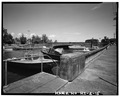 | 4,944 × 3,976 (18.75 MB) | Fæ (talk | contribs) | GWToolset: Creating mediafile for Fæ. HABS 11 July 2014 (1001:1200) |
You cannot overwrite this file.
File usage on Commons
The following page uses this file: