File:STUDIO VIEW OF PLAQUE PLACED ON MILL HOUSE AT TIME OF COMPLETION, COMMEMORATING EDWARD J. LUKE (SEE TEXT) - Sperry Corn Elevator Complex, Weber Avenue (North side), West of HAER CAL,39-STOCK,1-32.tif

Size of this JPG preview of this TIF file: 476 × 599 pixels. Other resolutions: 191 × 240 pixels | 381 × 480 pixels | 610 × 768 pixels | 814 × 1,024 pixels | 1,628 × 2,048 pixels | 4,020 × 5,057 pixels.
Original file (4,020 × 5,057 pixels, file size: 19.39 MB, MIME type: image/tiff)
Captions
Captions
Add a one-line explanation of what this file represents
Summary edit
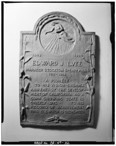
| STUDIO VIEW OF PLAQUE PLACED ON MILL HOUSE AT TIME OF COMPLETION, COMMEMORATING EDWARD J. LUKE (SEE TEXT) - Sperry Corn Elevator Complex, Weber Avenue (North side), West of Edison Street, Stockton, San Joaquin County, CA | ||||
|---|---|---|---|---|
| Photographer |
Anderson, Ed, creator |
|||
| Title |
STUDIO VIEW OF PLAQUE PLACED ON MILL HOUSE AT TIME OF COMPLETION, COMMEMORATING EDWARD J. LUKE (SEE TEXT) - Sperry Corn Elevator Complex, Weber Avenue (North side), West of Edison Street, Stockton, San Joaquin County, CA |
|||
| Depicted place | California; San Joaquin County; Stockton | |||
| Date | 1985 | |||
| Dimensions | 4 x 5 in. | |||
| Current location |
Library of Congress Prints and Photographs Division Washington, D.C. 20540 USA http://hdl.loc.gov/loc.pnp/pp.print |
|||
| Accession number |
HAER CAL,39-STOCK,1-32 |
|||
| Credit line |
|
|||
| Source | https://www.loc.gov/pictures/item/ca1390.photos.017139p | |||
| Permission (Reusing this file) |
|
|||

| Camera location | | View this and other nearby images on: OpenStreetMap |
|---|
File history
Click on a date/time to view the file as it appeared at that time.
| Date/Time | Thumbnail | Dimensions | User | Comment | |
|---|---|---|---|---|---|
| current | 04:42, 3 July 2014 |  | 4,020 × 5,057 (19.39 MB) | Fæ (talk | contribs) | GWToolset: Creating mediafile for Fæ. HABS batch upload 2 July 2014 (301:400) |
You cannot overwrite this file.
File usage on Commons
The following page uses this file: