File:The Holy Roman Empires Duchy of Antwerp and the Dominium of Malines- With the Eastern Flemish Areas and the Boundaries of Brabant Following from These WDL1102.png

Size of this preview: 715 × 600 pixels. Other resolutions: 286 × 240 pixels | 572 × 480 pixels | 916 × 768 pixels | 1,221 × 1,024 pixels.
Original file (1,221 × 1,024 pixels, file size: 2.38 MB, MIME type: image/png)
Captions
Captions
Add a one-line explanation of what this file represents
Summary edit
| Author |
|
||||||||||||||||||||||
| Title |
Русский: Княжество Антверп и доминион Малин Священной Римской империи: с восточными фламандскими районами и выходящими из них границами Брабанта.
Français : Le Saint Empire Romain - Duché d'Anvers et Domaine de Malines: Avec les territoires Flamands de l'Est et les frontières du Brabant en découlant
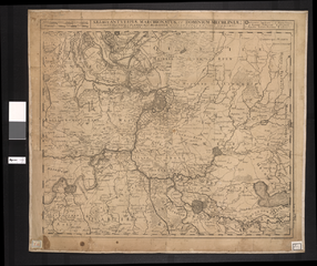
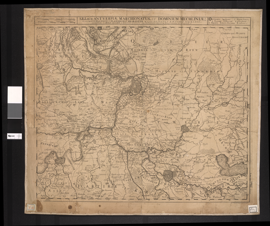
English: The Holy Roman Empires Duchy of Antwerp and the Dominium of Malines: With the Eastern Flemish Areas and the Boundaries of Brabant Following from These
中文:安特卫普与马利纳主权国的神圣罗马帝国: 东部佛兰芒语地区及与其接壤的布拉班特省边境
Português: O Sagrado Ducado de Antuérpia do Império Romano e do Domínio de Malines: Com as Zonas Orientais Flamengas e as Fronteiras de Brabant Seguindo a Partir Destes
العربية: دوقية أنتويرب ودومنيوم المالينز التابعة للإمبراطورية الرومانية المقدسة: مع المناطق الفلمنكية الشرقية وحدود برابانت انطلاقا من هذه
Español: El ducado de Amberes y el dominio de Malinas del Sacro Imperio Romano: con las zonas flamencas orientales y los límites de Barbante que de éstas se derivan |
||||||||||||||||||||||
| Description |
Русский: На этой карте концаXVII века изображено герцогство Брабант, в состав которого входили города Антверпен и Мехелен. Герцогство включало в себя современные бельгийские провинции: Фламандский Брабант, Валлонский Брабант, Антверпен и Брюссель, а также провинцию Северный Брабант на территории современных Нидерландов. Карта была выпущена в Амстердаме Карелом Аллардом (1648-1706 гг.), который — вместе со своим братом Абрахамом — взял на себя руководство делами фирмы отца, издателя карт из Амстердама, Хьюго Алларда. Семья Аллард была более известна благодаря выпущенным ими атласам карт, составленных другими авторами, нежели своим собственным картам.
Брабант (княжество) Français : Cette carte de la fin du 17ème siècle montre le Duché de Brabant, comprenant les villes d'Anvers et de Malines. Le Duché se composait de l'actuelle province belge du Brabant flamand, du Brabant Wallon, d'Anvers et de Bruxelles, ainsi que de la province du Brabant septentrional dans les Pays-Bas d'aujourd'hui. La carte fut publiée à Amsterdam par Karel Allard (1648-1706) qui, avec son frère Abraham, avait repris l'entreprise de leur père, l'éditeur cartograhique d'Amsterdam Hugo Allard. La famille Allard était plus connue pour publier des atlas de cartes de tiers plutôt que pour sa propre cartographie.
Brabant (Duché) English: This late-17th century map shows the Duchy of Brabant, including the cities of Antwerp and Mechelen. The duchy consisted of the modern-day Belgian provinces of Flemish Brabant, Walloon Brabant, Antwerp, and Brussels, as well as the province of North Brabant in the present-day Netherlands. The map was published in Amsterdam by Karel Allard (1648-1706) who, with his brother Abraham, had taken over the business of their father, the Amsterdam map publisher Hugo Allard. The Allard family was known more for publishing atlases of maps by others than for original cartography.
Brabant (Duchy) 中文:这幅 17 世纪末期的 的地图显示的是布拉邦大公国,包括安特卫普和梅赫伦等城市。 该大公国由现在比利时的佛兰芒布拉邦省、瓦隆布拉邦省、安特卫普和布鲁塞尔以及今天荷兰的北布拉邦省组成。 这幅地图是由卡雷尔·阿拉德(1648-1706 年)在阿姆斯特丹出版的,卡雷尔·阿拉德与他的兄弟亚伯拉罕一起接手了他们父亲的生意,他们的父亲是阿姆斯特丹的地图出版商雨果·阿拉德。 阿拉德家族多以出版他人所绘地图的地图集而出名,而不是自己原创的地图。
布拉班特(公国) Português: Este mapa do final do século XVII mostra o Ducado de Brabant, incluindo as cidades de Antuérpia e Mechelen. O ducado era constituído pelas atuais províncias do Brabante flamengo, Brabante Walloon, Antuérpia e Bruxelas, bem como a província de Brabante do Norte, na atual Holanda. O mapa foi publicado em Amsterdam por Karel Allard (1648-1706) que, junto com seu irmão Abraham, haviam assumido o negócio do seu pai, o editor de mapas Hugo Allard, de Amsterdam. A família Allard era mais conhecida pela publicação de atlas de mapas de terceiros do que por cartografias de sua própria autoria.
Brabant (Ducado) العربية: تظهر هذه الخريطة التي أُعدت في أواخرالقرن السابع عشر دوقية برابانت، بما فيها مدينتي أنتويرب وميشيلين. وتألفت الدوقية من المقاطعات البلجيكية الحديثة فليميش برابانت ووالون برابانت وأنتويرب وبروكسل، وكذلك مقاطعة برابانت الشمالية الواقعة في هولندا حاليا. نشر هذه الخريطة في أمستردام كاريل ألارد (1648-1706) الذي ورث، مع شقيقه إبراهام، أعمال والدهما، ناشر خرائط أمستردام هوغو ألارد . وكانت أسرة ألارد معروفة أكثر بنشر خرائط أطالس أعدها الآخرون وليس برسم الخرئط الأصلية.
برابانت (دوقية) Español: Este mapa de finales del siglo XVII muestra el ducado de Brabante, incluyendo las ciudades de Amberes y Malinas. El ducado comprendía las actuales provincias belgas de Brabante Flamenco, Brabante Valón, Amberes y Bruselas, así como la provincia de Brabante del Norte en los actuales Países Bajos. El mapa fue publicado en Ámsterdam por Karel Allard (1648-1706) quien, con su hermano Abraham, se habían hecho cargo de la empresa de su padre, el editor de mapas de Ámsterdam, Hugo Allard. La familia Allard era más conocida por la publicación de atlas de mapas de otros que por cartografía original.
Brabante (Ducado) |
||||||||||||||||||||||
| Date | 1688 | ||||||||||||||||||||||
| Medium |
Русский: Карты
Français : Cartes
English: Maps
中文:地图
Português: Mapas
العربية: خرائط
Español: Mapas |
||||||||||||||||||||||
| Dimensions |
English: 1 map : 50 x 58.5 centimeters |
||||||||||||||||||||||
| Collection |
Русский: Национальная библиотека Бразилии
Français : Bibliothèque nationale du Brésil
English: National Library of Brazil
中文:巴西国家图书馆
Português: Biblioteca Nacional do Brasil
العربية: مكتبة البرازيل الوطنية
Español: Biblioteca Nacional de Brasil |
||||||||||||||||||||||
| Place of creation |
Русский: Мехелен
Français : Mechelen
English: Mechelen
中文:梅赫伦
Português: Mechelen
العربية: ميشيلين
Español: Malinas |
||||||||||||||||||||||
| Notes | Original language title: S[acri] R[omani] I[mperii] sive Antverpiae Marchionatus et Dominium Mechliniae : cum orientalioribus Flandriae et Brabantiae hisce consequentibus terminis / auctore Carolo Allard | ||||||||||||||||||||||
| References | http://hdl.loc.gov/loc.wdl/brrjbn.1102 | ||||||||||||||||||||||
| Source/Photographer |
|
||||||||||||||||||||||
| Other versions |
|
||||||||||||||||||||||

Licensing edit
|
This is a faithful photographic reproduction of a two-dimensional, public domain work of art. The work of art itself is in the public domain for the following reason:
The official position taken by the Wikimedia Foundation is that "faithful reproductions of two-dimensional public domain works of art are public domain".
This photographic reproduction is therefore also considered to be in the public domain in the United States. In other jurisdictions, re-use of this content may be restricted; see Reuse of PD-Art photographs for details. | ||||
File history
Click on a date/time to view the file as it appeared at that time.
| Date/Time | Thumbnail | Dimensions | User | Comment | |
|---|---|---|---|---|---|
| current | 17:52, 10 March 2014 | | 1,221 × 1,024 (2.38 MB) | Fæ (talk | contribs) | =={{int:filedesc}}== {{Artwork |artist = |author ={{ru|1=Аллард, Карел (1648-1709?)}} {{fr|1=Allard, Carel (1648-1709?)}} {{en|1=Allard, Carel (1648-1709?)}} {{zh|1=阿拉德, 卡雷尔 (1648-1709?)}} {{pt|1=Allard, Carel (1648-1709?)}} {{ar... |
You cannot overwrite this file.
File usage on Commons
The following 2 pages use this file: