File:The first Muslim proposal on cantonisation of Bosnia and Herzegovina.png

Size of this preview: 632 × 599 pixels. Other resolutions: 253 × 240 pixels | 506 × 480 pixels | 810 × 768 pixels | 1,080 × 1,024 pixels | 1,770 × 1,678 pixels.
Original file (1,770 × 1,678 pixels, file size: 84 KB, MIME type: image/png)
Captions
Captions
Add a one-line explanation of what this file represents
Summary edit
Legend (English) edit
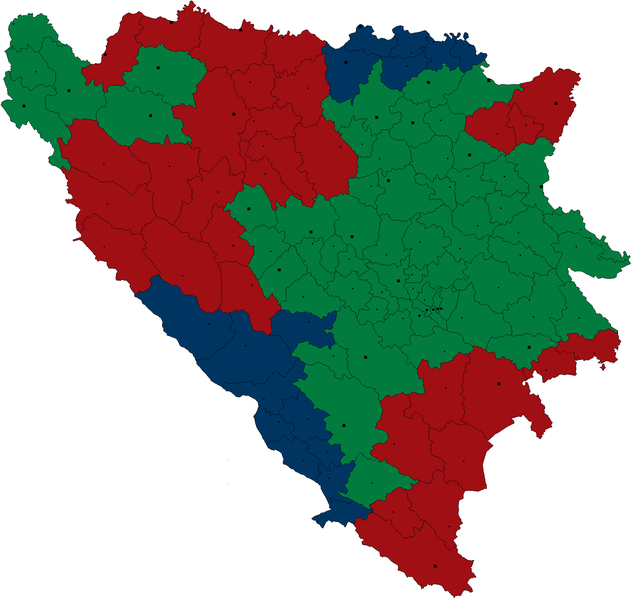
Bosniak
Croat
Serb
Summary edit
| Description |
English: Map of the first Bosniak proposal on federalisation of Bosnia and Herzegovina, from 25 June 1991. Adil Zulfikarpašić's proposal included the possibility of attaching Mostar to the Croat canton. |
| Date | |
| Source | Own work |
| Author | Bugoslav (this file); Владимир Варјачић (blank graphic map) |
| Other versions | See also: Serbian Autonomous Regions in Bosnia and Herzegovina |
Reference(s) edit
- Figure 11 at page 31 in: Klemenčić, Mladen. (1994) Territorial proposals for the settlement of the war in Bosnia-Hercegovina. in: Pratt, Martin; Schofield, Clive (Eds.) Boundary and Territory Briefing, Vol. 1, No. 3, ISBN 1-897643-15-2, International Boundaries Research Unit, Department of Geography, University of Durham, United Kingdom.
- Magazine Bosanski pogledi, 1991-06-25
Licensing edit
I, the copyright holder of this work, hereby publish it under the following licenses:
This file is licensed under the Creative Commons Attribution-Share Alike 3.0 Unported license.
- You are free:
- to share – to copy, distribute and transmit the work
- to remix – to adapt the work
- Under the following conditions:
- attribution – You must give appropriate credit, provide a link to the license, and indicate if changes were made. You may do so in any reasonable manner, but not in any way that suggests the licensor endorses you or your use.
- share alike – If you remix, transform, or build upon the material, you must distribute your contributions under the same or compatible license as the original.

|
Permission is granted to copy, distribute and/or modify this document under the terms of the GNU Free Documentation License, Version 1.2 or any later version published by the Free Software Foundation; with no Invariant Sections, no Front-Cover Texts, and no Back-Cover Texts. A copy of the license is included in the section entitled GNU Free Documentation License. |
You may select the license of your choice.
File history
Click on a date/time to view the file as it appeared at that time.
| Date/Time | Thumbnail | Dimensions | User | Comment | |
|---|---|---|---|---|---|
| current | 16:29, 9 July 2017 | | 1,770 × 1,678 (84 KB) | Drax90 (talk | contribs) | new version of the map |
| 14:52, 4 December 2014 |  | 1,770 × 1,678 (81 KB) | Ceha (talk | contribs) | rv (colors) | |
| 16:22, 7 October 2014 |  | 1,770 × 1,678 (100 KB) | Gryffindor (talk | contribs) | {{Information |Description= |Source={{own}} |Date= |Author= Gryffindor |Permission= |other_versions= }} | |
| 13:27, 25 February 2010 |  | 1,770 × 1,678 (81 KB) | Bugoslav (talk | contribs) | == {{int:filedesc}} == ===== Legend (English) ===== {{legend|#0080ff|Croatian canton}} {{legend|#00ff80|Muslim canton}} {{legend|#ff8080|Serbian canton}} *'''''Note''''': Adil Zulfikarpašić's proposal included the possibili |
You cannot overwrite this file.
File usage on Commons
The following 4 pages use this file:
File usage on other wikis
The following other wikis use this file:
- Usage on ar.wikipedia.org
- Usage on en.wikipedia.org
- Usage on hr.wikipedia.org
- Usage on sh.wikipedia.org
- Usage on sr.wikipedia.org