File:Transverse Section; West Elevation - Contoocook Railroad Bridge, Spanning Contoocook River at former Boston and Maine Railroad (originally Concord and Claremont Railroad), HAER NH-38 (sheet 5 of 8).tif
Size of this JPG preview of this TIF file: 800 × 533 pixels. Other resolutions: 320 × 213 pixels | 640 × 427 pixels | 1,024 × 683 pixels | 1,280 × 853 pixels | 2,560 × 1,707 pixels | 14,401 × 9,601 pixels.
Original file (14,401 × 9,601 pixels, file size: 315 KB, MIME type: image/tiff)
Captions
Captions
Add a one-line explanation of what this file represents
Summary edit
| Warning | The original file is very high-resolution. It might not load properly or could cause your browser to freeze when opened at full size. |
|---|
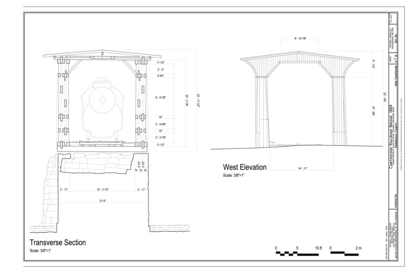
| Transverse Section; West Elevation - Contoocook Railroad Bridge, Spanning Contoocook River at former Boston and Maine Railroad (originally Concord and Claremont Railroad), Hopkinton, Merrimack County, NH | ||||
|---|---|---|---|---|
| Photographer |
Related names:
|
|||
| Title |
Transverse Section; West Elevation - Contoocook Railroad Bridge, Spanning Contoocook River at former Boston and Maine Railroad (originally Concord and Claremont Railroad), Hopkinton, Merrimack County, NH |
|||
| Depicted place | New Hampshire; Merrimack County; Hopkinton | |||
| Date | 2003 | |||
| Current location |
Library of Congress Prints and Photographs Division Washington, D.C. 20540 USA http://hdl.loc.gov/loc.pnp/pp.print |
|||
| Accession number |
HAER NH-38 (sheet 5 of 8) |
|||
| Credit line |
|
|||
| Notes |
|
|||
| References |
|
|||
| Source | http://lcweb2.loc.gov/master/pnp/habshaer/nh/nh0200/nh0277/sheet/00005a.tif | |||
| Permission (Reusing this file) |
|
|||

| Object location | | View this and other nearby images on: OpenStreetMap |
|---|
File history
Click on a date/time to view the file as it appeared at that time.
| Date/Time | Thumbnail | Dimensions | User | Comment | |
|---|---|---|---|---|---|
| current | 06:25, 29 July 2014 |  | 14,401 × 9,601 (315 KB) | Fæ (talk | contribs) | GWToolset: Creating mediafile for Fæ. HABS 24 July 2014 (2001:2300) |
You cannot overwrite this file.
File usage on Commons
The following page uses this file: