File:Turkic Languages distribution map.png

Size of this preview: 800 × 448 pixels. Other resolutions: 320 × 179 pixels | 640 × 359 pixels | 1,024 × 574 pixels | 1,572 × 881 pixels.
Original file (1,572 × 881 pixels, file size: 476 KB, MIME type: image/png)
Captions
Captions
Add a one-line explanation of what this file represents
Summary edit
| Description |
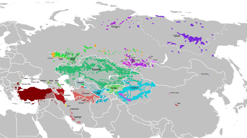
English: Map of the distribution of Turkic languages across Eurasia. |
| Date | |
| Source |
Own work.
This PNG graphic was created with Medibang. |
| Author | GalaxMaps |

|
This map image could be re-created using vector graphics as an SVG file. This has several advantages; see Commons:Media for cleanup for more information. If an SVG form of this image is available, please upload it and afterwards replace this template with
{{vector version available|new image name}}.
It is recommended to name the SVG file “Turkic Languages distribution map.svg”—then the template Vector version available (or Vva) does not need the new image name parameter. |
Licensing edit
I, the copyright holder of this work, hereby publish it under the following license:
This file is licensed under the Creative Commons Attribution-Share Alike 4.0 International license.
- You are free:
- to share – to copy, distribute and transmit the work
- to remix – to adapt the work
- Under the following conditions:
- attribution – You must give appropriate credit, provide a link to the license, and indicate if changes were made. You may do so in any reasonable manner, but not in any way that suggests the licensor endorses you or your use.
- share alike – If you remix, transform, or build upon the material, you must distribute your contributions under the same or compatible license as the original.
File history
Click on a date/time to view the file as it appeared at that time.
| Date/Time | Thumbnail | Dimensions | User | Comment | |
|---|---|---|---|---|---|
| current | 09:37, 17 April 2024 | | 1,572 × 881 (476 KB) | Golden (talk | contribs) | update Karabakh |
| 16:24, 27 September 2023 |  | 1,834 × 1,027 (473 KB) | GalaxMaps (talk | contribs) | fixed a few things that required fixing | |
| 15:21, 27 September 2023 |  | 1,834 × 1,027 (477 KB) | GalaxMaps (talk | contribs) | Added Dobrujan Tatar | |
| 00:49, 8 August 2023 |  | 1,636 × 851 (505 KB) | Zanahary (talk | contribs) | Cropped 31 % horizontally, 20 % vertically using CropTool with precise mode. | |
| 18:27, 17 June 2023 |  | 2,372 × 1,063 (568 KB) | Golden (talk | contribs) | Reverted to version as of 16:26, 19 April 2023 (UTC) Got a source for that? Astara in Iran is Azeri-speaking. Areas you added in Azerbaijan (Yardimli and parts of Lankaran) are again Azeri-speaking. Need I remind you that all Talysh in Azerbaijan are bilingual in Azeri too? | |
| 11:32, 17 June 2023 |  | 2,372 × 1,063 (705 KB) | AryanTuranica (talk | contribs) | Minor edits. Removed Talysh areas incorrectly labeled as Azerbaijani. Added missing Turkmen areas in Iran. | |
| 16:26, 19 April 2023 |  | 2,372 × 1,063 (568 KB) | Richaringan (talk | contribs) | Reverted to version as of 15:55, 18 February 2023 (UTC) Falsification de l'étendue de certaines langues (POV-pushing) | |
| 12:06, 19 April 2023 |  | 1,920 × 860 (524 KB) | Yasin820 (talk | contribs) | modification | |
| 11:57, 19 April 2023 |  | 1,920 × 860 (524 KB) | Yasin820 (talk | contribs) | . | |
| 15:55, 18 February 2023 |  | 2,372 × 1,063 (568 KB) | GalaxMaps (talk | contribs) | added labels |
You cannot overwrite this file.
File usage on Commons
The following 11 pages use this file:
- User:Chumwa/OgreBot/Travel and communication maps/2021 December 11-20
- User:Chumwa/OgreBot/Travel and communication maps/2022 April 11-20
- User:Chumwa/OgreBot/Travel and communication maps/2022 January 11-20
- User:Chumwa/OgreBot/Travel and communication maps/2022 May 1-10
- User:Chumwa/OgreBot/Travel and communication maps/2022 May 21-31
- User:Chumwa/OgreBot/Travel and communication maps/2023 April 11-20
- User:Chumwa/OgreBot/Travel and communication maps/2023 August 1-10
- User:Chumwa/OgreBot/Travel and communication maps/2023 February 10-18
- User:Chumwa/OgreBot/Travel and communication maps/2023 June 11-20
- User:Chumwa/OgreBot/Travel and communication maps/2023 September 21-30
- User:Chumwa/OgreBot/Travel and communication maps/2024 April 11-20
File usage on other wikis
The following other wikis use this file:
- Usage on azb.wikipedia.org
- Usage on az.wikipedia.org
- Usage on ba.wikipedia.org
- Usage on ce.wikipedia.org
- Usage on en.wikipedia.org
- Usage on es.wikipedia.org
- Usage on fa.wikipedia.org
- Usage on fr.wikipedia.org
- Usage on hr.wikipedia.org
- Usage on incubator.wikimedia.org
- Usage on it.wikipedia.org
- Usage on ko.wikipedia.org
- Usage on ku.wikipedia.org
- Usage on lv.wikipedia.org
- Usage on mg.wikipedia.org
- Usage on pt.wikipedia.org
- Usage on ru.wikipedia.org
- Usage on sq.wikipedia.org
- Usage on ta.wikipedia.org
- Usage on tr.wikipedia.org
- Usage on vi.wikipedia.org
- Usage on zh.wikipedia.org