File:VIEW SOUTHWEST, COMPRESSOR PADS - Imperial Carbon Black Plant (Ruin), North side of North Fork of Hughes River along Bunnell Run Road just over 0.5 mile from its intersection HAER WVA,43-HARVL.V,2-2.tif

Size of this JPG preview of this TIF file: 734 × 600 pixels. Other resolutions: 294 × 240 pixels | 588 × 480 pixels | 940 × 768 pixels | 1,254 × 1,024 pixels | 2,507 × 2,048 pixels | 5,153 × 4,209 pixels.
Original file (5,153 × 4,209 pixels, file size: 20.69 MB, MIME type: image/tiff)
Captions
Captions
Add a one-line explanation of what this file represents
Summary edit
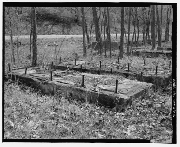
| VIEW SOUTHWEST, COMPRESSOR PADS - Imperial Carbon Black Plant (Ruin), North side of North Fork of Hughes River along Bunnell Run Road just over 0.5 mile from its intersection with State Route 16, Harrisville, Ritchie County, WV | ||||
|---|---|---|---|---|
| Photographer |
Kemp, Emory, creator |
|||
| Title |
VIEW SOUTHWEST, COMPRESSOR PADS - Imperial Carbon Black Plant (Ruin), North side of North Fork of Hughes River along Bunnell Run Road just over 0.5 mile from its intersection with State Route 16, Harrisville, Ritchie County, WV |
|||
| Description |
Imperial Oil and Gas Products Company; Mann, J L; Hartman, Joseph; Meyer, Lauren, transmitter; Kemp, Emory, photographer; Past and Present, Consultants, The Kemp Group, Incorporated, historian |
|||
| Depicted place | West Virginia; Ritchie County; Harrisville | |||
| Date | 2000 | |||
| Dimensions | 4 x 5 in. | |||
| Current location |
Library of Congress Prints and Photographs Division Washington, D.C. 20540 USA http://hdl.loc.gov/loc.pnp/pp.print |
|||
| Accession number |
HAER WVA,43-HARVL.V,2-2 |
|||
| Credit line |
|
|||
| Notes |
|
|||
| Source | https://www.loc.gov/pictures/item/wv0449.photos.192768p | |||
| Permission (Reusing this file) |
|
|||

File history
Click on a date/time to view the file as it appeared at that time.
| Date/Time | Thumbnail | Dimensions | User | Comment | |
|---|---|---|---|---|---|
| current | 22:22, 4 August 2014 |  | 5,153 × 4,209 (20.69 MB) | Fæ (talk | contribs) | GWToolset: Creating mediafile for Fæ. HABS 2014-08-04 3801-4000 |
You cannot overwrite this file.
File usage on Commons
The following page uses this file: