File:Val-d'Isère 2.jpg
Size of this preview: 800 × 247 pixels. Other resolutions: 320 × 99 pixels | 640 × 197 pixels | 1,024 × 316 pixels | 1,280 × 395 pixels | 5,454 × 1,683 pixels.
Original file (5,454 × 1,683 pixels, file size: 3.49 MB, MIME type: image/jpeg)
File information
Structured data
Captions
Summary edit
DescriptionVal-d'Isère 2.jpg |
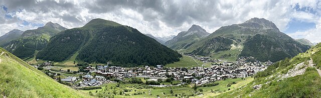
English: Val-d'Isère and Rocher de Bellevarde. |
Date | |
Source | Own work |
Author | Tiia Monto |
Camera location | 45° 27′ 03.16″ N, 6° 59′ 09.31″ E | View this and other nearby images on: OpenStreetMap | 45.450878; 6.985919 |
---|
Licensing edit
I, the copyright holder of this work, hereby publish it under the following license:
This file is licensed under the Creative Commons Attribution 4.0 International license.
- You are free:
- to share – to copy, distribute and transmit the work
- to remix – to adapt the work
- Under the following conditions:
- attribution – You must give appropriate credit, provide a link to the license, and indicate if changes were made. You may do so in any reasonable manner, but not in any way that suggests the licensor endorses you or your use.
Annotations InfoField | This image is annotated: View the annotations at Commons |
3231
402
143
102
5454
1683
Rocher du Charvet
File history
Click on a date/time to view the file as it appeared at that time.
Date/Time | Thumbnail | Dimensions | User | Comment | |
---|---|---|---|---|---|
current | 20:31, 1 January 2024 | 5,454 × 1,683 (3.49 MB) | Kulmalukko (talk | contribs) | Uploaded own work with UploadWizard |
You cannot overwrite this file.
File usage on Commons
There are no pages that use this file.
Metadata
This file contains additional information such as Exif metadata which may have been added by the digital camera, scanner, or software program used to create or digitize it. If the file has been modified from its original state, some details such as the timestamp may not fully reflect those of the original file. The timestamp is only as accurate as the clock in the camera, and it may be completely wrong.
Camera manufacturer | Apple |
---|---|
Camera model | iPhone 13 |
Exposure time | 1/3,413 sec (0.00029299736302373) |
F-number | f/1.6 |
ISO speed rating | 50 |
Date and time of data generation | 13:29, 24 July 2023 |
Lens focal length | 5.1 mm |
Latitude | 45° 27′ 3.16″ N |
Longitude | 6° 59′ 9.31″ E |
Altitude | 1,953.157 meters above sea level |
Width | 13,818 px |
Height | 3,788 px |
Bits per component |
|
Pixel composition | RGB |
Orientation | Normal |
Number of components | 3 |
Horizontal resolution | 72 dpi |
Vertical resolution | 72 dpi |
Software used | Adobe Photoshop CC (Windows) |
File change date and time | 22:05, 1 January 2024 |
Y and C positioning | Centered |
Exif version | 2.32 |
Date and time of digitizing | 13:29, 24 July 2023 |
Meaning of each component |
|
APEX shutter speed | 11.736811705814 |
APEX aperture | 1.3561438092556 |
APEX brightness | 9.6304195313596 |
APEX exposure bias | 0 |
Metering mode | Pattern |
Flash | Flash did not fire |
DateTimeOriginal subseconds | 459 |
DateTimeDigitized subseconds | 459 |
Supported Flashpix version | 1 |
Color space | Uncalibrated |
Sensing method | One-chip color area sensor |
Scene type | A directly photographed image |
Custom image processing | Panorama |
White balance | Auto white balance |
Focal length in 35 mm film | 26 mm |
Scene capture type | Standard |
Speed unit | Kilometers per hour |
Speed of GPS receiver | 0.21335598038026 |
Reference for direction of image | True direction |
Direction of image | 24.30636596489 |
Reference for bearing of destination | True direction |
Bearing of destination | 24.30636596489 |
GPS date | 24 July 2023 |
Lens used | iPhone 13 back camera 5.1mm f/1.6 |
Date metadata was last modified | 00:05, 2 January 2024 |
Unique ID of original document | AC12220D05CE35E378B6C79B3C60A150 |