File:Yakehashiri lava flow Aerial photograph A.jpg

Size of this preview: 800 × 561 pixels. Other resolutions: 320 × 224 pixels | 640 × 449 pixels | 1,024 × 718 pixels | 1,280 × 898 pixels | 2,637 × 1,850 pixels.
Original file (2,637 × 1,850 pixels, file size: 1.75 MB, MIME type: image/jpeg)
Captions
Captions
Add a one-line explanation of what this file represents
Summary edit
| Description |
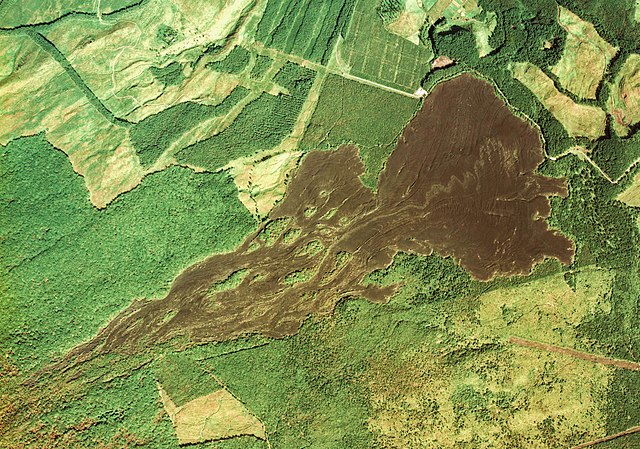
English: Yakehashiri lava flow Aerial photograph A. Kipukas surrounded by lava flows from Iwate volcano, Japan. (Move the mouse pointer over the image to see them.)
日本語: 岩手山の焼走り熔岩流周辺の空中写真。cto-76-4_c7_23を利用 |
| Date | |
| Source | 国土情報ウェブマッピングシステム |
| Author | 国土交通省 |
| Object location | | View this and other nearby images on: OpenStreetMap |
|---|
Licensing edit

|
The copyright holder of this file, the Ministry of Land, Infrastructure, Transport and Tourism of Japan, allows anyone to use it for any purpose, provided that the copyright holder is properly attributed. Redistribution, derivative work, commercial use, and all other use is permitted. |
Attribution:
Copyright © National Land Image Information (Color Aerial Photographs), Ministry of Land, Infrastructure, Transport and Tourism
|
 |
This image is copyrighted by the Ministry of Land, Infrastructure, Transport and Tourism of Japan. For terms of use, see the stipulation to use of National Land Information (in Japanese) and message from MLIT (in Japanese and English). When you display this image on an article, include the following phrase in the description: "Made based on National Land Image Information (Color Aerial Photographs), Ministry of Land, Infrastructure, Transport and Tourism".
|
| Annotations | This image is annotated: View the annotations at Commons |
File history
Click on a date/time to view the file as it appeared at that time.
| Date/Time | Thumbnail | Dimensions | User | Comment | |
|---|---|---|---|---|---|
| current | 06:34, 11 June 2012 | | 2,637 × 1,850 (1.75 MB) | さかおり (talk | contribs) | {{Information |Description ={{en|1=Yakehashiri lava flow Aerial photograph A}} {{ja|1=焼走り熔岩流付近の空中写真。cto-76-4_c7_23を利用}} |Source =国土情報ウェブマッピングシステム |Author =国土交通... |
You cannot overwrite this file.
File usage on Commons
There are no pages that use this file.
File usage on other wikis
The following other wikis use this file: