User:Goran tek-en/discussions/2023
Notification about possible deletion edit

|
Some contents have been listed at Commons:Deletion requests so that the community can discuss whether they should be kept or not. We would appreciate it if you could go to voice your opinion about this at their entry.
If you created these pages, please note that the fact that they have been proposed for deletion does not necessarily mean that we do not value your kind contribution. It simply means that one person believes that there is some specific problem with them, such as a copyright issue. Please see Commons:But it's my own work! for a guide on how to address these issues. |
Affected:
And also:
- File:MapOfWWIWesternFrontArea.svg
- File:Distribution map of Rhinella schneideri.svg
- File:Amhara elevation map.svg
Yours sincerely, — 🇺🇦Jeff G. ツ please ping or talk to me🇺🇦 10:13, 23 January 2023 (UTC)
South Sudan borders edit
Hello.
Can you add the borders of South Sudan in the widely used maps File:Carrefour world map.svg ![]() Done, File:Dunkin Donuts world map.svg
Done, File:Dunkin Donuts world map.svg ![]() Done, File:Dunkin Donuts world map updated.png
Done, File:Dunkin Donuts world map updated.png ![]() Done, File:H&M world map.svg
Done, File:H&M world map.svg ![]() Done and File:IKEA world map.svg
Done and File:IKEA world map.svg ![]() Done?
Done?
Can you remove Russia in the widely used File:Dunkin Donuts world map updated.png ![]() Done, just like in File:Dunkin Donuts world map.svg
Done, just like in File:Dunkin Donuts world map.svg ![]() Done(Russia was already edited) and add the borders of South Sudan in all these aforementioned maps?
Done(Russia was already edited) and add the borders of South Sudan in all these aforementioned maps?
Sepatately, can you add the borders of South Sudan in the maps in the request section "South Sudan borders required in orthographic maps" which I added in Commons:Graphic Lab/Map workshop back in October 2022?
Can you also add the border of South Sudan in File:US and Russian bases and facilities.jpg as well? ![]() Done
Done
I also requested an update of this map in Commons:Graphic Lab/Map workshop back in October 2022, which is just below the "South Sudan borders required in orthographic maps" section. This map also requires a few other corrections as well, which I addressed in this section.
Yours sincerely, Maphobbyist (talk) 10:42, 7 February 2023 (UTC)
- @Maphobbyist I have started on this as you can see above. Check everything, it's so easy to make a mistake.
- All the maps which are bitmaps with different angels are impossible to get correct and hard to get the line to be the same as the others, and are a bit tricky to fix. So I want you to check this draft and see if that is fine for you. I have to guess for the rotation/angel of the border in all of that kind of map. So tell me, is this "quality" enough? --please ping me-- Goran tek-en (talk) 17:53, 7 February 2023 (UTC)
- Thank you very much for the updates. The draft with the new border is perfect. However, Azerbaijan needs to be colored in white, because it does not host any foreign base and never hosted a U.S. base. It hosted a Russian base until 2013. Georgia, likewise needs to be colored in blue (like Armenia or Belarus), because it also never hosted a U.S. base. It has Russian bases on its territory occupied by Russia (Abkhazia and South Ossetia). --Maphobbyist (talk) 09:31, 8 February 2023 (UTC)
- @Maphobbyist Please always ping me. One thing at the time, right now my question was just the draft, the rest I will do in time, thanks. --please ping me-- Goran tek-en (talk) 16:02, 8 February 2023 (UTC)
- @Maphobbyist Now I have
 Done the files here and I will work on your requests as Commons:Graphic Lab/Map workshop back in October 2022. --please ping me-- Goran tek-en (talk) 19:57, 9 February 2023 (UTC)
- @Maphobbyist Now I have
- @Maphobbyist Please always ping me. One thing at the time, right now my question was just the draft, the rest I will do in time, thanks. --please ping me-- Goran tek-en (talk) 16:02, 8 February 2023 (UTC)
- Thank you very much for the updates. The draft with the new border is perfect. However, Azerbaijan needs to be colored in white, because it does not host any foreign base and never hosted a U.S. base. It hosted a Russian base until 2013. Georgia, likewise needs to be colored in blue (like Armenia or Belarus), because it also never hosted a U.S. base. It has Russian bases on its territory occupied by Russia (Abkhazia and South Ossetia). --Maphobbyist (talk) 09:31, 8 February 2023 (UTC)
- Thank you very much for all your work.
- In File:US and Russian bases and facilities.jpg Done, can you color Georgia in the same light blue color as Armenia, Belarus and Syria? It appears as dark blue, like as a part of Russia. That is the last required correction left.
- In File:US and Russian bases and facilities.jpg
- File:Togoland map.png Done has not been uploaded and South Sudan does not appear.
- File:Togoland map.png
- (In File:Iraq (orthographic projection).svg and File:Russian Federation (orthographic projection).svg, there is not a way of uploading them nor is there a "revert" button, which is unusual. Both files seem to be protected from edits somehow, even though both need to be updated and are used across Wikipedia. I don't understand why they reverted them to the obsolete versions and their reason for doing so. I will ask the users who last reverted them, to update them back.) --Maphobbyist (talk) 17:57, 10 February 2023 (UTC)
- Maphobbyist I hope I got it right now. They might be protected against vandalism but should there not be a template then? If you can't out anything there is one way I never tried, there is an code edit directly for svg but I have never used it before so I don't know if it will work here. See what you can find out, thanks. --please ping me-- Goran tek-en (talk) 19:21, 10 February 2023 (UTC)
- (In File:Iraq (orthographic projection).svg and File:Russian Federation (orthographic projection).svg, there is not a way of uploading them nor is there a "revert" button, which is unusual. Both files seem to be protected from edits somehow, even though both need to be updated and are used across Wikipedia. I don't understand why they reverted them to the obsolete versions and their reason for doing so. I will ask the users who last reverted them, to update them back.) --Maphobbyist (talk) 17:57, 10 February 2023 (UTC)
- I wrote to the user who last reverted File:Russian Federation (orthographic projection).svg; the other user who last reverted File:Iraq (orthographic projection).svg has recently retired. I requested an update for both files from the active user. Hopefully, he will reply and explain, and perhaps revert them to the updated version. Separately, how do I ping you for all the other files that you have updated, so you can close my requests in Commons:Graphic Lab/Map? They are all up to date. Maphobbyist (talk) 21:47, 11 February 2023 (UTC)
- @Maphobbyist I'm not really sure I understand your questions on ping and close but here are answers to what I think you asked.
- If you want to ping me put this code
{{Ping|Goran tek-en}}in edit mode (to the right of your requests (or section) headline there is a link for edit) or Replay mode. - To close your requests. You as the requester should put out a piece of code which you will find at the bottom of your request in edit mode (to the right of your requests headline there is a link for edit). Copy and paste it above
<!-- - If this is not what you asked for please explain again, thanks.
- If you want to ping me put this code
- --please ping me-- Goran tek-en (talk) 18:31, 12 February 2023 (UTC)
- @Maphobbyist I'm not really sure I understand your questions on ping and close but here are answers to what I think you asked.
- I wrote to the user who last reverted File:Russian Federation (orthographic projection).svg; the other user who last reverted File:Iraq (orthographic projection).svg has recently retired. I requested an update for both files from the active user. Hopefully, he will reply and explain, and perhaps revert them to the updated version. Separately, how do I ping you for all the other files that you have updated, so you can close my requests in Commons:Graphic Lab/Map? They are all up to date. Maphobbyist (talk) 21:47, 11 February 2023 (UTC)
- Hello.
- No codes appear in edit mode. Because I use the internet from my cell phone, many things that appear on a computer screen, don't appear on the cell phone, and nor can I for example upload a file in Wikimedia Commons.
- --Maphobbyist (talk) 15:04, 14 February 2023 (UTC)
@Maphobbyist: On this specific request there is no such code even on a computer. I guess the request wasn't created as it should and that's why the code is missing. If you check your other request there is that code on a computer. I have put out the code for those two. --please ping me-- Goran tek-en (talk) 15:49, 14 February 2023 (UTC)
File:Dunkin Donuts world map updated.png edit
|
|
File:Dunkin Donuts world map updated.png has been listed at Commons:Deletion requests so that the community can discuss whether it should be kept or not. We would appreciate it if you could go to voice your opinion about this at its entry.
If you created this file, please note that the fact that it has been proposed for deletion does not necessarily mean that we do not value your kind contribution. It simply means that one person believes that there is some specific problem with it, such as a copyright issue. Please see Commons:But it's my own work! for a guide on how to address these issues. |
2600:100C:A21B:9ED1:55B9:69E3:601D:D8ED 08:28, 9 February 2023 (UTC)
A barnstar for you! edit

|
The Graphic Designer's Barnstar | |
| Thank you for your great contributions on Commons:Graphic Lab/Map workshop. Please keep up the good work! HeminKurdistan (talk) 18:07, 27 February 2023 (UTC) |
- @HeminKurdistan Thanks for that, I enjoy this work. --please ping me-- Goran tek-en (talk) 18:08, 27 February 2023 (UTC)
File:Dunkin Donuts world map.svg edit
|
|
File:Dunkin Donuts world map.svg has been listed at Commons:Deletion requests so that the community can discuss whether it should be kept or not. We would appreciate it if you could go to voice your opinion about this at its entry.
If you created this file, please note that the fact that it has been proposed for deletion does not necessarily mean that we do not value your kind contribution. It simply means that one person believes that there is some specific problem with it, such as a copyright issue. Please see Commons:But it's my own work! for a guide on how to address these issues. |
2600:100C:A202:5967:9887:2E7F:5894:8FB5 02:06, 4 June 2023 (UTC)
Western Sahara Walls edit
You remember File:Western sahara territorial control topographic map-en.svg and File:Western sahara moroccan walls topographic map-en.svg, I mentioned that there is one more wall built in 2021 I did not have data yet. Now I have found some, so can you include it?--Antemister (talk) 08:29, 24 June 2023 (UTC)
- @Antemister Sure just provide so I understand it. --please ping me-- Goran tek-en (talk) 15:53, 26 June 2023 (UTC)
- Sent you two shapefiles, bermaa refers to a tiny gap which is still a natural barrier, and bermbb the new wall, finished in March 2021 (no not know the start date of the building).--Antemister (talk) 07:00, 27 June 2023 (UTC)
- The email address I have saved seems to be inactive, if you did not receive anything, sent me a Wikimail.--Antemister (talk) 07:04, 27 June 2023 (UTC)
- @Antemister You will have to provide me with some kind of references. I have the shape files but I can't see how the fit them geographical to the surrounding? Print screen or something, thanks. --please ping me-- Goran tek-en (talk) 13:50, 29 June 2023 (UTC)
- Sent you a screenshot, it is in the northeastern area, on Moroccon territory next to the border to Algeria. The red line shows the natural barrier which is currently shown in the map, the yellow squares the 5th wall. The grey dots are the new wall, while in the area which the brown dots there is no wall the barrier remains natural (likely to small to be visible in that scale). The part of the 5th wall which is enclosed, the western border of the "parallelogram", is to be removed, as internal walls are not shown anymore in the maps.--Antemister (talk) 16:05, 29 June 2023 (UTC)
- @Antemister Thanks, found the area and position but I don't understand the color information as I can't see it like that.
- This is what I get when opening your zip in QGIS. Could you somehow explain in this image or another screenshot where I can see that info, thanks. --please ping me-- Goran tek-en (talk) 11:10, 1 July 2023 (UTC)
- QGIS assigns random colors to layer if you do not set a fixed one, so when you opened it you see completely different colors. Here green is the new wall and yellow the small remaining natural barrier.--Antemister (talk) 16:44, 1 July 2023 (UTC)
- @Antemister 9th Wall draft. --please ping me-- Goran tek-en (talk) 09:44, 3 July 2023 (UTC)
- seen it, three issues:
- 1) the northern border of that parallelogram bermbb is of course a natural barrier, but there is now anyway a wall built near that cliff, so that should be also indicated here.
- 2) don't remove that part of the 5th wall behind, it is still there.
- 3) for the date write "???-Mar 2021", like for the 2nd one.
- --Antemister (talk) 16:57, 3 July 2023 (UTC)
- @Antemister I don't understand #1. --please ping me-- Goran tek-en (talk) 10:12, 5 July 2023 (UTC)
- Sent you an email with an image.--Antemister (talk) 15:33, 5 July 2023 (UTC)
- @Antemister Daft 9-2. --please ping me-- Goran tek-en (talk) 17:43, 5 July 2023 (UTC)
- Yes that's it. For me it looks like that the legend for the 9th wall is smaller, but maybe I am mistaken. Can you also edit the other variant?--Antemister (talk) 20:03, 5 July 2023 (UTC)
- @Antemister Checked the legend. Will be away for a few days will be back. --please ping me-- Goran tek-en (talk) 11:02, 6 July 2023 (UTC)
- @Antemister Are draft 9-1. --please ping me-- Goran tek-en (talk) 11:55, 11 July 2023 (UTC)
- @Yes, fine, as expected, thanks!--Antemister (talk) 17:44, 12 July 2023 (UTC)
- @Antemister New versions uploaded Done --please ping me-- Goran tek-en (talk) 12:33, 15 July 2023 (UTC)
- @Antemister New versions uploaded
- @Yes, fine, as expected, thanks!--Antemister (talk) 17:44, 12 July 2023 (UTC)
- Yes that's it. For me it looks like that the legend for the 9th wall is smaller, but maybe I am mistaken. Can you also edit the other variant?--Antemister (talk) 20:03, 5 July 2023 (UTC)
- @Antemister Daft 9-2. --please ping me-- Goran tek-en (talk) 17:43, 5 July 2023 (UTC)
- Sent you an email with an image.--Antemister (talk) 15:33, 5 July 2023 (UTC)
- @Antemister I don't understand #1. --please ping me-- Goran tek-en (talk) 10:12, 5 July 2023 (UTC)
- @Antemister 9th Wall draft. --please ping me-- Goran tek-en (talk) 09:44, 3 July 2023 (UTC)
- QGIS assigns random colors to layer if you do not set a fixed one, so when you opened it you see completely different colors. Here green is the new wall and yellow the small remaining natural barrier.--Antemister (talk) 16:44, 1 July 2023 (UTC)
- Sent you a screenshot, it is in the northeastern area, on Moroccon territory next to the border to Algeria. The red line shows the natural barrier which is currently shown in the map, the yellow squares the 5th wall. The grey dots are the new wall, while in the area which the brown dots there is no wall the barrier remains natural (likely to small to be visible in that scale). The part of the 5th wall which is enclosed, the western border of the "parallelogram", is to be removed, as internal walls are not shown anymore in the maps.--Antemister (talk) 16:05, 29 June 2023 (UTC)
- @Antemister You will have to provide me with some kind of references. I have the shape files but I can't see how the fit them geographical to the surrounding? Print screen or something, thanks. --please ping me-- Goran tek-en (talk) 13:50, 29 June 2023 (UTC)
- The email address I have saved seems to be inactive, if you did not receive anything, sent me a Wikimail.--Antemister (talk) 07:04, 27 June 2023 (UTC)
- Sent you two shapefiles, bermaa refers to a tiny gap which is still a natural barrier, and bermbb the new wall, finished in March 2021 (no not know the start date of the building).--Antemister (talk) 07:00, 27 June 2023 (UTC)
Vatican City flag and coat of arms edit
@Goran tek-en: hello! I have a new request for you. since 7 June 2023, Vatican City has its new official models of its coat of arms and flag.
My request is as follow:
1) change the colours of File:Coat of arms of the Vatican City.svg so that they match the ones of this version
2) change the colours and the details of File:Flag of the Vatican City.svg to make it faithful to this version. Do not add the pole upholding the flag.
3) Show me your work as a preview. Veverve (talk) 13:51, 9 July 2023 (UTC)
Coat of arms edit
- @Veverve 1) The two of them are so different in their appearance, the svg has tonings and surfaces with different shades of the same color while the pdf-image just has one flat color for each, also there are different parts in the two versions.
- So I don't really know what to do, the don't look the same in many parts, is that not important? --please ping me-- Goran tek-en (talk) 12:15, 11 July 2023 (UTC)
- @Goran tek-en: do what you think will work best so that your versions look as faithful as you can to the Vatican.va PDF models. Vatican.va PDF models are the rule, they are the ones to follow and to reproduce. Veverve (talk) 13:34, 11 July 2023 (UTC)
- I mean that if you feel like it is needed to change more than the colours (shapes, remove or adding details, etc.) to be faithful to the Vatican.va models, feel free to do so. Veverve (talk) 20:14, 12 July 2023 (UTC)
- @Goran tek-en: how is it going? Veverve (talk) 14:03, 20 July 2023 (UTC)
- @Veverve It's going, I'm drawing a new version. I know that I don't put in so many hours in commons at this time but I will be back with a draft. --please ping me-- Goran tek-en (talk) 16:34, 20 July 2023 (UTC)
- @Goran tek-en: no problem. Thanks for keeping me in the loop! Veverve (talk) 16:54, 20 July 2023 (UTC)
- @Veverve To my understand often COA and other patterns like that are similar on left-right side, mirrored. In this there are some differences I don't understand why and sometimes it's drawn in an inexact way. I don't know if this is on purpose or what so I have had to make some adaptions when drawing a new one, so it's not an exact copy.
- Draft 1 COA. feedback thanks. --please ping me-- Goran tek-en (talk) 15:35, 22 July 2023 (UTC)
- This is great, but it looks like some ink has spilled at two points. This spilled ink should be removed. I have coloured, as best as I can, those two spilled ink parts in purple, and I have indicated them with two arrows: https://imgur.com/a/GHhIMIh Veverve (talk) 17:18, 22 July 2023 (UTC)
- @Veverve It was mistakes from my side, good you spotted them.
- I suggested we upload this as a new file as there must be some kind of interest of keeping the different version historically.
- So I think this somehow also should be added in the name and even rename the old one?
- Name of the file
- Description (/language)
- Captions/s (/language)
- Category/ies at commons
- Structured data/Items portrayed in this file, the Q#, to be able to upload it at commons, thanks.
- --please ping me-- Goran tek-en (talk) 11:17, 23 July 2023 (UTC)
- @Goran tek-en:
- Coat of arms of Vatican City State - 2023 version
- The coat of arms of Vatican City State, as per the 2023 w:en:Fundamental Law of Vatican City State, reproducing Annex B which contains the official depiction of this version. See 2023 Fundamental Law of Vatican City State, art. 23, n. 2.
- Coat of arms of Vatican City State - 2023 version
- COA, Category:Crossed keys of Saint Peter, Category:Keys saltirewise in heraldry
- Depicts: Coat of arms of the Holy See [Q62395714]
- Veverve (talk) 15:41, 23 July 2023 (UTC)
- @Veverve Now you can find it here file:Coat of arms of Vatican City State - 2023 version.svg.
- I will start with the flag now. --please ping me-- Goran tek-en (talk) 17:49, 23 July 2023 (UTC)
- @Goran tek-en: could you release the cot of arms image
under a copyleft license, since you are the one who made the SVG image, so that there is no copyright question? Veverve (talk) 18:11, 23 July 2023 (UTC) - @Goran tek-en: Please release the coat of arms under Template:PD-retouched-user. Please use the same license for the flag. Veverve (talk) 18:17, 23 July 2023 (UTC)
- @Veverve Changed. --please ping me-- Goran tek-en (talk) 14:06, 24 July 2023 (UTC)
- @Goran tek-en: could you release the cot of arms image
- @Goran tek-en:
- This is great, but it looks like some ink has spilled at two points. This spilled ink should be removed. I have coloured, as best as I can, those two spilled ink parts in purple, and I have indicated them with two arrows: https://imgur.com/a/GHhIMIh Veverve (talk) 17:18, 22 July 2023 (UTC)
- @Goran tek-en: no problem. Thanks for keeping me in the loop! Veverve (talk) 16:54, 20 July 2023 (UTC)
- @Veverve It's going, I'm drawing a new version. I know that I don't put in so many hours in commons at this time but I will be back with a draft. --please ping me-- Goran tek-en (talk) 16:34, 20 July 2023 (UTC)
- @Goran tek-en: how is it going? Veverve (talk) 14:03, 20 July 2023 (UTC)
![]() Done --please ping me-- Goran tek-en (talk) 13:33, 1 August 2023 (UTC)
Done --please ping me-- Goran tek-en (talk) 13:33, 1 August 2023 (UTC)
Flag edit
@Goran tek-en: how is it going? Veverve (talk) 08:14, 31 July 2023 (UTC)
- @Veverve Flag A draft-1. --please ping me-- Goran tek-en (talk) 15:00, 31 July 2023 (UTC)
- @Goran tek-en:
- The overall tone/shading should be darker
- The light grey colour should be grey (i.e. the light grey colour should be darker)
- The tiara should be thinner and longer (reach higher)
- The scarves should reach a few pixels higher
- Veverve (talk) 15:46, 31 July 2023 (UTC)
- @Veverve Flag a draft-2. --please ping me-- Goran tek-en (talk) 17:34, 31 July 2023 (UTC)
- @Goran tek-en: The proportions seem off to me, see this. Could you check the proportions?
- Also, could you render the size of your PNG drafts so that they are the same as the model's? I have had to resize your draft in order to make the proportion comparison. Veverve (talk) 00:27, 1 August 2023 (UTC)
- @Veverve To me this seems like another level of accuracy than we had on the COA. Also as I said on that, that the drawing in the pdf is not that consistent or exact so my drawing is not an exact copy, just as the COA is not.
- --please ping me-- Goran tek-en (talk) 13:53, 1 August 2023 (UTC)
- @Goran tek-en:
- Veverve (talk) 01:14, 2 August 2023 (UTC)
- @Veverve For the shapes I couldn't see any purple on your image? --please ping me-- Goran tek-en (talk) 15:51, 2 August 2023 (UTC)
- There is, I just checked. If you use a 800% zoom in in Microsoft Paint, you can see them. They are in the parts in the middle of the tiare. You have to zoom in a lot. Veverve (talk) 17:27, 2 August 2023 (UTC)
- @Veverve But if you look at the allegato_B.pdf in which the crown is bigger and more visible you can better judge it.
- In this image I have the B pdf to the left and the crown from my flag to the right. From what I can see my crown is pretty similar. --please ping me-- Goran tek-en (talk) 16:31, 3 August 2023 (UTC)
- Ok, I see it was simply a resolution problem, now that you have showed an image that is in higher resolution I see the details better.
- You can upload it. Here are the details:
- Flag of Vatican City State - 2023 version
- The Flag of Vatican City State, as per the 2023 w:en:Fundamental Law of Vatican City State, reproducing Annex A which contains the official depiction of this version. See 2023 Fundamental Law of Vatican City State, art. 23, n. 1.
This 2023 flag is very similar to the flag used in the 1929 Fundamental Law of Vatican City State, see here, p. 35. Thus, it is in the public domain.
- Flag of Vatican City State - 2023 version
- Category:Flags of the Vatican City, Category:Crossed keys of Saint Peter, Category:Keys saltirewise in heraldry
- Depicts: flag of Vatican City [Q79198]
- Veverve (talk) 02:47, 4 August 2023 (UTC)
- Oh, and do not forget to put it under Template:PD-retouched-user license. Veverve (talk) 04:23, 5 August 2023 (UTC)
- There is, I just checked. If you use a 800% zoom in in Microsoft Paint, you can see them. They are in the parts in the middle of the tiare. You have to zoom in a lot. Veverve (talk) 17:27, 2 August 2023 (UTC)
- @Veverve For the shapes I couldn't see any purple on your image? --please ping me-- Goran tek-en (talk) 15:51, 2 August 2023 (UTC)
- @Veverve Flag a draft-2. --please ping me-- Goran tek-en (talk) 17:34, 31 July 2023 (UTC)
- @Goran tek-en:
@Veverve Now you can find it here, Flag of Vatican City State - 2023 version
![]() Done --please ping me-- Goran tek-en (talk) 13:18, 5 August 2023 (UTC)
Done --please ping me-- Goran tek-en (talk) 13:18, 5 August 2023 (UTC)
- @Veverve Do you want me to upload it two times but with different info? --please ping me-- Goran tek-en (talk) 12:38, 5 August 2023 (UTC)
Veverve Because I don't understand this part:
- This 2023 flag is very similar to the flag used in the 1929 Fundamental Law of Vatican City State, see here, p. 35. Thus, it is in the public domain.
- Flag of Vatican City State - 2023 version
- Category:Flags of the Vatican City, Category:Crossed keys of Saint Peter, Category:Keys saltirewise in heraldry
- Depicts: flag of Vatican City [Q79198] --please ping me-- Goran tek-en (talk) 13:45, 5 August 2023 (UTC)
- This 2023 flag is very similar to the flag used in the 1929 Fundamental Law of Vatican City State, see here, p. 35. Thus, it is in the public domain.
Vatican City map edit
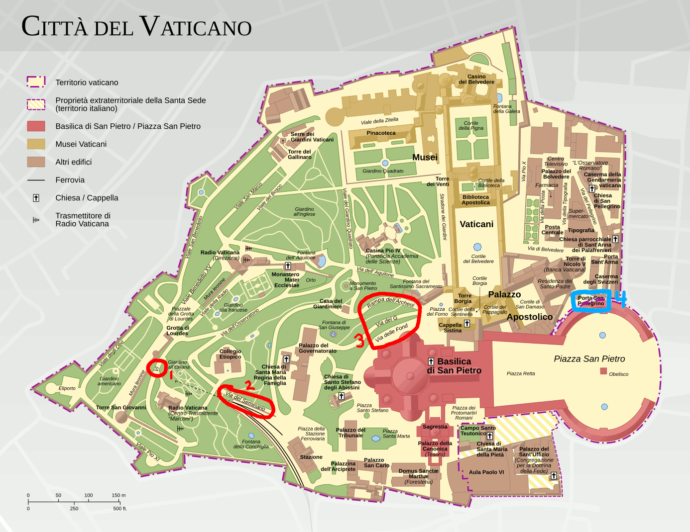
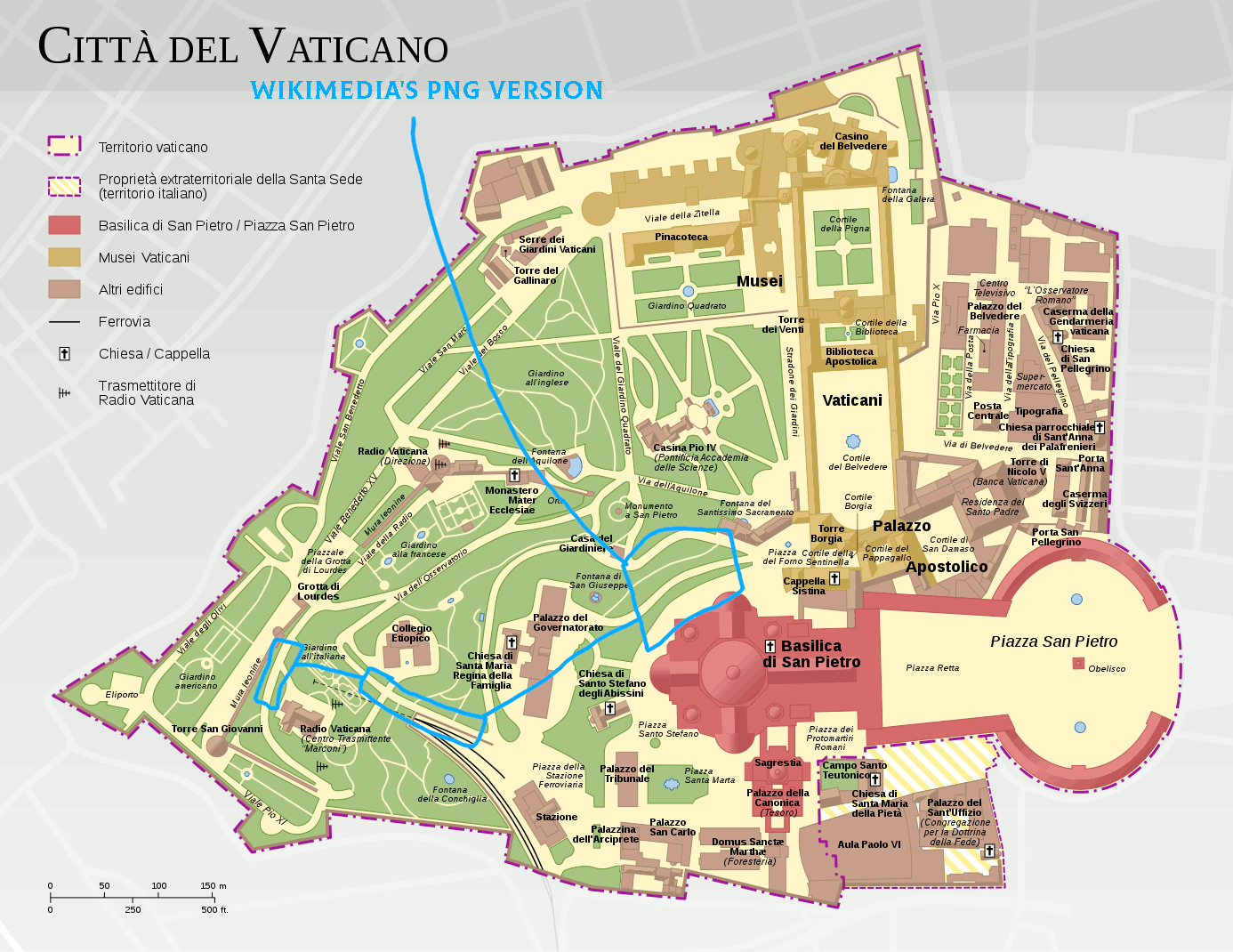
@Goran tek-en: Hello! I also have a Vatican-related request for you. In File:Vatican_City_map.svg there is bit incorrectly marked as part of Vatican City that is actually part of Italy. It is a narrow strip known as the w:Ricciolo d'Italia, which is hilighted in red here: File:Ricciolo_d'Italia_localization_map.svg
1) Please edit File:Vatican_City_map.svg to remove the yellow color from the aforementioned strip of land, replacing it with gray of the Italy layer below it, and adjust the purple dot-dash outline if it would look good.
2) Upload the new version of that svg file.
3) Render the svg as PNGs files in order to update these four versions as well: File:Vatican_City_map_EN.png, File:Vatican_City_map_DE.png, File:Vatican_City_map_IT.png, File:Vatican_City_map_FR.png
Thank you. –Vuccala (talk) 04:34, 11 July 2023 (UTC)
- @Vuccala I will look at it in a week or so. --please ping me-- Goran tek-en (talk) 12:16, 11 July 2023 (UTC)
- @Vuccala Here is a draft-1 for you to give me feedback on, thanks. --please ping me-- Goran tek-en (talk) 17:03, 22 July 2023 (UTC)
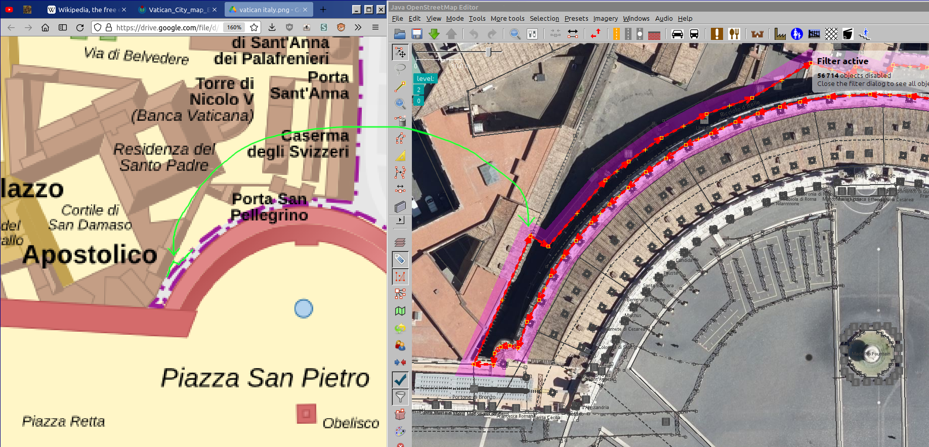
- @Goran tek-en Very good job, thank you! Just 1 tiny detail I think you could fix, which I marked here: https://files.catbox.moe/5pwg9t.png. The border should go ¾ of the way up that building before angling at 90° angle and joining what you drew.
- I also noticed 1 additional thing you should add: mark where the border zigzags through the 'Aula Paolo VI' hall. Like so: https://files.catbox.moe/v9ksxw.png
- If you need the reference map I used it's found here on OpenStreetMap. –Vuccala (talk) 18:18, 22 July 2023 (UTC)
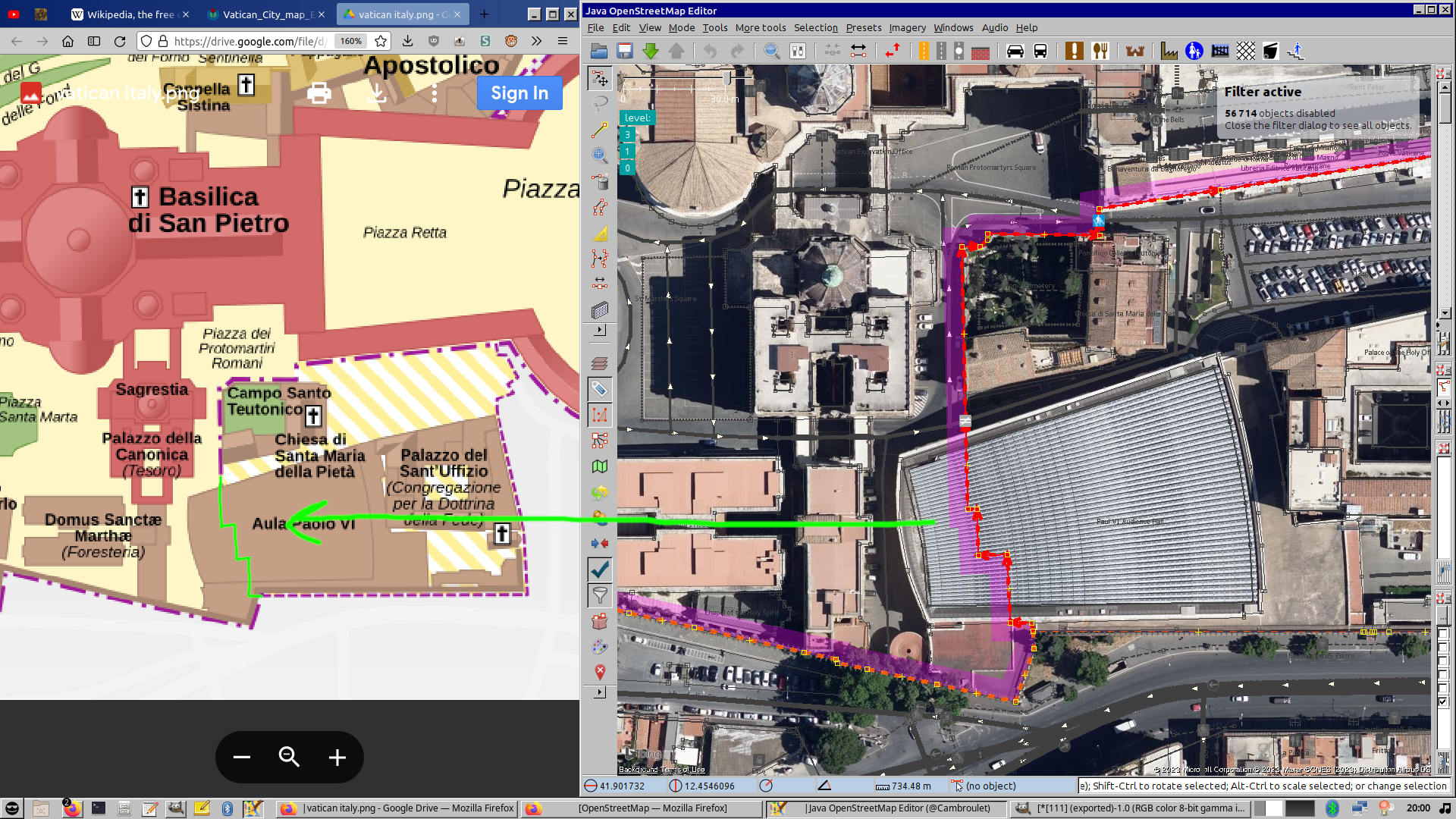
- @Vuccala The zizags was actually there already but below the (under) the building so I lifted it up. This means I lifted all of the vatican border up on top of everything so you have to check so this hasen't affected something else in a bad way. I tried to see and couldn't see anything but I don't have your knowledge about this.
- Draft-2. --please ping me-- Goran tek-en (talk) 11:32, 23 July 2023 (UTC)
- @Goran tek-en Here is a gif that flashes between your Draft-2 and the original file https://files.catbox.moe/sk7q53.gif
I've circled and numbered the issues. 1,2,3: these street names went missing from your draft.4: the text "Porta San Pellegrino" in Draft-2 now goes below the purple dashed line, so please raise the text above it. Thank you. –Vuccala (talk) 22:00, 23 July 2023 (UTC)- @Vuccala This is so strange because when I view that png on drive it looks like this screenshot and there the 3 names are appearing. Lifted number 4 (not in the screenshot but in the original file). --please ping me-- Goran tek-en (talk) 14:20, 24 July 2023 (UTC)
- @Goran tek-en Sorry, my mistake! I got it the wrong way around: the missing street names where not in your draft, but rather in Wikimedia's png version. This gif flashes between the svg and Wikimedia's autoconverted png version. Unless you know the reason why it misrenders and can fix it, I'd say you're done! When you upload the file, for the comment you can write "Added missing Ricciolo d'Italia border strip north of Saint Peter's Square". Thank you. –Vuccala (talk) 15:13, 24 July 2023 (UTC)
- @Vuccala I uploaded a new version but there is still issues with the texts and it might be that they are textpath, because there is problems with that. If you want me to look in to it I can do that.
- For the png's in different languages I don't understand. It's very hard to create language versions for this map in png. It would be much better to create svg files for each language and upload them and delete the png's. But then someone would need to add all the translations here like
- Italian-New language
- for all of them and everything. --please ping me-- Goran tek-en (talk) 16:02, 24 July 2023 (UTC)
- @Vuccala I have now removed all the texts paths so that text rendering issue (5 names) should be fixed now. For the png textversions see above.
- @Goran tek-en Making an svg version for each language sounds like a good idea! It will have to be done manually, since the user who uploaded the translated PNG versions in 2013 seems not to have uploaded his svg files. I'll try to do it myself using the SVG Translate tool that Wikimedia provides, and then upload them. That is all, you may mark this as done. Thank you again. –Vuccala (talk) 21:46, 24 July 2023 (UTC)
- @Vuccala I have now removed all the texts paths so that text rendering issue (5 names) should be fixed now. For the png textversions see above.
- @Goran tek-en Sorry, my mistake! I got it the wrong way around: the missing street names where not in your draft, but rather in Wikimedia's png version. This gif flashes between the svg and Wikimedia's autoconverted png version. Unless you know the reason why it misrenders and can fix it, I'd say you're done! When you upload the file, for the comment you can write "Added missing Ricciolo d'Italia border strip north of Saint Peter's Square". Thank you. –Vuccala (talk) 15:13, 24 July 2023 (UTC)
- @Vuccala This is so strange because when I view that png on drive it looks like this screenshot and there the 3 names are appearing. Lifted number 4 (not in the screenshot but in the original file). --please ping me-- Goran tek-en (talk) 14:20, 24 July 2023 (UTC)
- @Goran tek-en Here is a gif that flashes between your Draft-2 and the original file https://files.catbox.moe/sk7q53.gif
![]() Done --please ping me-- Goran tek-en (talk) 15:11, 26 July 2023 (UTC)
Done --please ping me-- Goran tek-en (talk) 15:11, 26 July 2023 (UTC)
Removing white background edit
Could you remove the white background of File:Streeter's Four-Document Hypothesis.svg? Veverve (talk) 20:42, 13 July 2023 (UTC)
- @Veverve New version uploaded Done --please ping me-- Goran tek-en (talk) 12:38, 15 July 2023 (UTC)
Vatican City map languages edit
Vuccala As we are going to use the base map (with out any texts) for several images I will start with checking that.
- For my work it's easier if I have the texts here (so I can copy it all) like Italian-New language but for the English I will use the material you have translated.
- In the file there are different types of text; normal, italic, bold and different sizes. Do you know why or you can see a pattern e.g. does bold always represent buildings and so on? --please ping me-- Goran tek-en (talk) 13:09, 8 August 2023 (UTC)
@Goran tek-en: :
- The file being discussed: File:Vatican_City_map.svg
- The fonts used are as follows:
- Large and bold:
- Main tourist areas. Red & yellow in the legend (Vatican Museums, Apostolic Palace, St. Peter's Basilica/Square)
- Bold:
- Named buildings
- Italics:
- Roads (all kept in Italian)
- Courtyards, Squares, Gardens, Fountains, (Parentheticals)
- Places of lesser importance like Supermarket and Heliport
- Large and bold:
- You can reference the old English version if you need help with the text placement: File:Vatican_City_map_EN.png. Reproducing the text size / position exactly isn't necessary. You can use your own aesthetic judgement to make it look pleasing.
- Three final points:
- I forgot to translate Radio Vaticana (Direzione) to Vatican Radio (Administration). It is on the left side, halfway down the image. Please make that replacement.
- Please check that the last word of the road "Via del Seminario Etiopico" (northwest of the Railway station) isn't cut off. In the svg I uploaded it appears cut off.
- If you think it would look good, you may add a compass rose to the map, such as File:Simple_compass_rose.svg or File:Gray compass rose.svg above the scale or below the legend. North is directly up.
- Three final points:
- –Vuccala (talk) 01:32, 9 August 2023 (UTC)
Italian edit
| Extended content | ||
|---|---|---|
Those drafts are PNG versions of the original SVG file I'm working in and will upload to commons.
–Vuccala (talk) 21:21, 26 August 2023 (UTC)
|
- Vuccala, yes now we have it, thanks. The file is now uploaded to Vatican City map IT and on the IT PNG I have put a SVG available as the texts renders well for what I can see but please check.
- So if this is fine I will start with the EN version, but I should keep strett names in IT? --please ping me-- Goran tek-en (talk) 17:32, 30 August 2023 (UTC)
- @Goran tek-en: To finish up here, I checked your SVG and the PNG Wikimedia creates from it a final time and everything looks good and is correct. I went ahead and updated the links on all the Wikipedias that linked to the Italian PNG to use your SVG instead. (In cases where article editing was locked, I requested the change in the discussion pages). Done –Vuccala (talk) 16:16, 3 September 2023 (UTC)
- @Goran tek-en: To finish up here, I checked your SVG and the PNG Wikimedia creates from it a final time and everything looks good and is correct. I went ahead and updated the links on all the Wikipedias that linked to the Italian PNG to use your SVG instead. (In cases where article editing was locked, I requested the change in the discussion pages).
- Vuccala, yes now we have it, thanks. The file is now uploaded to Vatican City map IT and on the IT PNG I have put a SVG available as the texts renders well for what I can see but please check.
English edit
Vuccala Draft EN-1. The red texts are missing translations in the PNG file. --please ping me-- Goran tek-en (talk) 11:14, 3 September 2023 (UTC)
- @Goran tek-en: These are the English translations:
Cortile Borgia Borgia Courtyard Cortile del Pappagallo Courtyard of the Parrots Campo Santa Teutonico Teutonic Cemetary Chiesa di San Pietro in Borgo Church of St. Peter in Borgo L'Osservatore Romano The Roman Observer
- And by the way, for future reference, to remove a Redirect from an uploaded file (like I did earlier), all you have to do is click "Edit" on the file's page, and delete the line that says "#REDIRECT [[File:filename]]". –Vuccala (talk) 16:36, 3 September 2023 (UTC)
- @Vuccala Draft EN-2. --please ping me-- Goran tek-en (talk) 15:41, 4 September 2023 (UTC)
- @Goran tek-en: Errors to fix:
- "Cortile della Sentinella" should be "Courtyard of the Sentinel"
- "Pinacotheca" should be "Art Gallery"
- "Drugstore" should be "Pharmacy"
- "Pontifical Academy of Scienes": "Pontifical Academy of Sciences"
- "Etiopian College" should be: "Pontifical Ethiopian College"
- "Piaza della Stazione Ferroviaria": you forgot to translate to: "Railway Station Square"
- "Residence of the Arch-Priest" should be "Residence of the Archpriest"
- "Congregation for the Doctrine of the Faith" should be "Dicastery for the Doctrine of the Faith"
- "Television center" should be "Vatican Media"
- See if you can make "Borgia Courtyard" not be hyphenated
- For sake of consistency and brevity...
- "Saint Martha's Square" should be "St. Martha's Square"
- "Palace of Saint Charles" should ve "Palace of St. Charles"
- "Church of Saint Stephen of the Abyssinians" should be "Church of St. Stephen of the Abyssinians"
- "Chapel of Santa Maria Regina della Famiglia" should be "Church of St. Mary Queen of the Family"
- "Church of Saint Pelligrino" should be "Church of St. Peregrin"
- "Parish Church Saint Anne of the Palafrenieri" should be "Church of St. Anne of the Pontifical Grooms"
- "Saint Peter Memorial" should be "St. Peter Memorial"
- "Domus Sanctæ Marthæ" should be "St. Martha's House"
- –Vuccala (talk) 23:33, 4 September 2023 (UTC)
- @Vuccala Draft EN-3, and now I will be away for a week or so. --please ping me-- Goran tek-en (talk) 15:23, 7 September 2023 (UTC)
- @Goran tek-en: Well done, I could only find a single thing to fix:
- the final letter is missing in: "St. Peter Memorial"
- After you fix that, you can upload it as File:Vatican_City_map_EN.svg. Then I'll update all the English Wikipedias' that use the old file to point to your new file. And then (since I don't know much German or French) I think we're done, yes? –Vuccala (talk) 22:28, 7 September 2023 (UTC)
- @Vuccala Now you can find it here Vatican City map EN.
- Would it not be better if you could find someone with the lacking languages because I can do the same work with them, I actually believed we would. --please ping me-- Goran tek-en (talk) 16:31, 17 September 2023 (UTC)
- @Goran tek-en: Thank you. I have gone through all the Wikipedias and updated their links to use your new file. I have also made a post in Graphics Lab to seek a French and German speaking volunteer here: Wikipedia:Wikipedia:Graphics_Lab/Map_workshop#French_and_German_speaker_needed_to_check_translation_of_Vatican_City_Map --–Vuccala (talk) 03:46, 18 September 2023 (UTC)
- @Goran tek-en: Well done, I could only find a single thing to fix:
- @Vuccala Draft EN-3, and now I will be away for a week or so. --please ping me-- Goran tek-en (talk) 15:23, 7 September 2023 (UTC)
- @Goran tek-en: Errors to fix:
- @Vuccala Draft EN-2. --please ping me-- Goran tek-en (talk) 15:41, 4 September 2023 (UTC)
French edit
File:Vatican_City_map_FR.png Awaiting volunteer...
German edit
File:Vatican_City_map_DE.png Awaiting volunteer...
Request - Diagram legends from French to English translation edit
Hi @Goran tek-en: Long time. I wonder if you update these two images with the English legends. They are currently in French. The diagrams are
You can see it is some kind of consumption of potatoes or something I don't know. I'll can give you a list of English legends sometime today, if your about. Scope creep (talk) 09:40, 2 September 2023 (UTC)
- @Scope creep I can do that, just to be sure: you want English versions of those two files, New uploads? --please ping me-- Goran tek-en (talk) 16:54, 2 September 2023 (UTC)
- Goran, is it possible to keep the original files, and use the Translate tool to add the English labels, or are the originals not suitable for that? Mathglot (talk) 00:55, 4 September 2023 (UTC)
- @Mathglot, @Scope creep I have never used the tool but it's a svg so it seems as it should work.
- So I will mark this as Done but if you need me later on just ping me, thanks. --please ping me-- Goran tek-en (talk) 15:25, 4 September 2023 (UTC)
- I think something has to be done to enable the svg for label translation, but I'm not sure. I'll go find a previous example where I did this with someone's help, and find out. Mathglot (talk) 18:56, 4 September 2023 (UTC)
- @Mathglot As mentioned before I have never used it and I'm not sure that you need me for using it. Read about it here. --please ping me-- Goran tek-en (talk) 15:01, 7 September 2023 (UTC)
- I think something has to be done to enable the svg for label translation, but I'm not sure. I'll go find a previous example where I did this with someone's help, and find out. Mathglot (talk) 18:56, 4 September 2023 (UTC)

- User:TillmanR, you helped me once before with label translation on an svg; that discussion is here. Can you explain to Goran what it is you have to do to enable label translation via the tool? This is regarding the two svg's listed at the top of this discussion. Thanks, Mathglot (talk) 19:06, 4 September 2023 (UTC)
- Scope creep, okay, I added the labels for the first one, but it's not showing up in the image to the right, not sure why not. There's a discussion at Help talk:SVG about it. Once we figure out the accessibility issue, maybe you'd like to try your hand at translating the labels for the other one? Mathglot (talk) 08:13, 9 September 2023 (UTC)
- Update: User:Glrx has given a detailed response at Help talk:SVG. Apparently, there is a known mediawiki bug that interferes with the display of English translations of French-labeled images. Glrx has upped the priority on task TT337199 to "High", so hopefully that will help resolve this. Meanwhile, a previous fr ⟶ en image translation was resolved through a workaround, so if need be, we can resort to that. Mathglot (talk) 19:20, 10 September 2023 (UTC)
File:Undivided India.jpg edit
|
|
File:Undivided India.jpg has been listed at Commons:Deletion requests so that the community can discuss whether it should be kept or not. We would appreciate it if you could go to voice your opinion about this at its entry.
If you created this file, please note that the fact that it has been proposed for deletion does not necessarily mean that we do not value your kind contribution. It simply means that one person believes that there is some specific problem with it, such as a copyright issue. Please see Commons:But it's my own work! for a guide on how to address these issues. |
Omphalographer (talk) 19:40, 18 September 2023 (UTC)
File:Eurasian Economic Union (orthographic projection).svg edit
|
|
File:Eurasian Economic Union (orthographic projection).svg has been listed at Commons:Deletion requests so that the community can discuss whether it should be kept or not. We would appreciate it if you could go to voice your opinion about this at its entry.
If you created this file, please note that the fact that it has been proposed for deletion does not necessarily mean that we do not value your kind contribution. It simply means that one person believes that there is some specific problem with it, such as a copyright issue. Please see Commons:But it's my own work! for a guide on how to address these issues. |
UA0Volodymyr (talk) 19:03, 7 October 2023 (UTC)
Excuses edit
Sorry for the misunderstanding earlier, didn’t knew you were the only one authorised to add sources in the Moorish banner Nourerrahmane (talk) 16:42, 28 October 2023 (UTC)
- @Nourerrahmane It's not easy at all to understand all the different things and purposes here at commons, I don't think any of us knows everything, the most important is that we learn as time goes and we respect each others. --please ping me-- Goran tek-en (talk) 17:34, 28 October 2023 (UTC)
- Naturally, also i like your work, and since you're a graphic worker, i would love to ask you if you are fine with working on this emblem of the Regency of Algiers, it has a lot of mistakes and i'm sure that your contribution will make it better File:Coat of arms of the Regency of Algiers.png Nourerrahmane (talk) 17:40, 28 October 2023 (UTC)
- @Nourerrahmane I can do that but then I will create a version as a svg.
- But first there are some things I don't understand with File:Coat of arms of the Regency of Algiers.png.
- I don't understand French or Arabic but I have looked at the links of your sources and at none I can see the picture you have uploaded.
- The Source is for the creator/uploader to state which source that is used to be able to create/copy or other wise for the uploaded image which I can't see here.
- For me (with my language limitations) all you have put in Source should be in Description if there at all, to me this is like reference material on a wikipedia page and commons is not wikipedia or an encyclopedia. The image can be inserted in a wikipedia page with this topic and there the reference material fits well.
- ---
- So at this stage I can't see from where or how you have obtained this png file, if it's from a free source or not so to my understanding it could be deleted from commons. --please ping me-- Goran tek-en (talk) 12:16, 29 October 2023 (UTC)
- @Goran tek-en It was actually taken from this website [1]https://histoires-et-tradions-d-algerie.blogspot.com/2021/12/lhistoire-de-lalgerie-des-origines-nos.html, which a faithful recreation of what the images in the links of the sources show and the descriptions provided in written sources. the original Creator didn't put restrictions or copyright in his website about this Coat of Arms. so this is public domaine Nourerrahmane (talk) 12:30, 29 October 2023 (UTC)
- [2]https://gallica.bnf.fr/ark:/12148/bpt6k58281506
- [3]https://gallica.bnf.fr/ark:/12148/bpt6k667326
- [4]https://archive.org/details/Casbah.d_Alger/page/n75/mode/2up?view=theater
- You can just scroll down to see them, as you can see they are public domaine since the sources go back the 19th century, the creator in his website did a faithful reproduction of them based on the the 3 written source in commons (he has them in his website), so wether actually he has copyright in his blog or not, it's public domaine. Nourerrahmane (talk) 12:38, 29 October 2023 (UTC)
- @Nourerrahmane For 2 and 3, I can only see one page (can't scroll down) and it's not on that page.
- For 1 there are so many images you would have to link directly to the image you used.
- 4 is not your source either.
- If someone creates a reproduction based on material in the public domain, that specific reproduction can still have a copyright on it.
- So I still can't see or understand your source, sorry if you think I'm to picky on this but it's very important with sources. --please ping me-- Goran tek-en (talk) 12:50, 29 October 2023 (UTC)
- @Goran tek-en
- - For 1: it's a long page, you will find the arms slowy below the middle when you scroll down, in a title called "Drapeaux" mans flags in french
- - For 2 and 3: the arms are in the front page in the bottom, you can't miss them
- - For 4: didn't quite understand what "not my source" means, it's acutally an arabic scholarly source about the ancient buildings in Algeria
- - Here a bigger version of it in this website: https://www.hubert-herald.nl/Algeria.htm (you scroll down you'll find it it's not long)
- Sure but the Website i took the Armas from doesn't have any copyright restricitons in it. Nourerrahmane (talk) 13:04, 29 October 2023 (UTC)
- @Nourerrahmane
- 1 You can't expect people to search thru a long page like that, link directly to the correct image.
- 2 3 Those are of so poor quality they can't have been used to create the uploaded image.
- 4 Just it's not your source.
- Sorry but it seems we misunderstand each other, just show your exact source.
- I will not work on this if I can't see and confirm your source because if it turns out not to be free, all the work I will do on the svg file might be for nothing, as also it can be deleted because of a non free source. --please ping me-- Goran tek-en (talk) 13:38, 29 October 2023 (UTC)
- The source is shown, if you can't scroll then you won't be able to see the arms nor check if it is copyrighted or not, although this is a blog.
- Thank you anyways Nourerrahmane (talk) 14:04, 29 October 2023 (UTC)
- Naturally, also i like your work, and since you're a graphic worker, i would love to ask you if you are fine with working on this emblem of the Regency of Algiers, it has a lot of mistakes and i'm sure that your contribution will make it better File:Coat of arms of the Regency of Algiers.png Nourerrahmane (talk) 17:40, 28 October 2023 (UTC)
Western Sahara maps edit
Hello @Goran tek-en, I have seen your maps on Western Sahara (this and this ones to put some examples) and I really loved them! I wonder if you could make a map based on this style for the divisions of the Spanish Sahara displaying Saguia el-Hamra, Río de Oro (and another one with Cape Juby), another one for the Moroccan invasion of Western Sahara and another one for the MINURSO bases. Another suggestion could also be the map of the 1974 Spanish census (click me). More maps can also be found here, mainly in Spanish which I'd be more than glad to help translate! I am currently improving articles on Western Sahara and I think that the design of your maps and it being more or less consistently used for the historic maps would be great! Thanks in advance! Tidjani Saleh (talk) 13:12, 20 November 2023 (UTC)
- @Tidjani Saleh I'm happy you find my graphic work useful, thanks.
- Yes, I can help you but remember that I have zero knowledge of the topics themselves so I'm depending on your knowledge and that you will work with me all the way.
- You are talking about several different maps and already there I get a bit confused, please be very specific and don't give more sources/option than I need.
- So if we can work on one map at the time and just give me info about that. Also try to explain what you want the map to depict and show the viewer, and we will work from there.
- --please ping me-- Goran tek-en (talk) 15:44, 20 November 2023 (UTC)
- @Tidjani Saleh Did you want us to work on those maps? --please ping me-- Goran tek-en (talk) 12:34, 24 November 2023 (UTC)
Azad Hind tiger edit
Hello @Goran tek-en:
You have done great work on File:Interpreted Azad Hind Gov. emblem.svg. But the tiger image used for reference is blurry and have lot of noise. government and government was led by , who was also responsible for raising the en:Indian Legion of Nazi Germany.
The Indian Legion also beared a springing tiger as it's symbol. If you could then please also add another image file of the tiger used by the German army legion. The new vectorised SVG format image could be used instead of the black and white one.
Here are some of the images -


.svg)
.svg)
.svg)
.svg)
.svg)
Reference links -
Thank you in advance and will be waiting for your reply.
Regards - Soap Boy 1 (talk) 08:15, 25 December 2023 (UTC)
- @Soap Boy 1 Yes the source for File:Interpreted Azad Hind Gov. emblem.svg was really bad so there is a lot of guess work in it.
- Those two sources Colour for the Free India Legion 1942-1945 and Indische Legion Shield are svg files so all that needs to be done is to remove all which is not needed and save it. Can you do that by yourself or do you need my help, also you would have to pick which as they are slightly different.
- --please ping me-- Goran tek-en (talk) 16:06, 26 December 2023 (UTC)
- @Soap Boy 1 I need you response if you want me to do something. --please ping me-- Goran tek-en (talk) 15:14, 1 January 2024 (UTC)
--please ping me-- Goran tek-en (talk) 15:26, 7 January 2024 (UTC)